Your chance to win an awesome package we have put together with our SeaNav app and B&G. SeaNav automatically hooks up with the B&G Zeus Touch over WiFi and uses the navigation data from their system (gps, course, wind, speed, lay lines, depth, AIS etc.) to display in SeaNav and on the Pebble SmartWatch with our free Pebble SeaNav app. Check out the competition details here
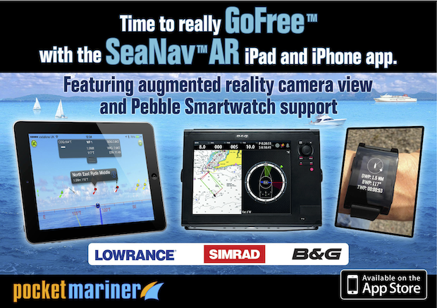
SeaNav now hooks up with Simrad, Lowrance and B&G MFD’s via WiFi GoFree and can use all the live navigation data including Position, AIS, Wind and Depth to display on your iPhone , iPad or Pebble Smartwatch wherever you are on your boat. We’ll be at the METS trade show in Amsterdam November 19th -21st . Come and see for yourself and try out the Pebble Smartwatch too – METS 2013 – stand(s):01.120, 01.147
Our unique AR view mode allows you to view buoys, lights, ships, waypoints and track overlaid on your iPhone or iPad live camera view. With “AR LockOn” you can select a target on the chart and then be guided to it in the AR camera view.
Find that ship on the horizon and instantly see its name, range and bearing.
Spot the next marker buoy.
See your route and next waypoint
Tap the “eye” icon at the top left to switch AR mode on, then tilt your device up to see a live camera of the scene and boats around you. As you turn round and view buoys and ships, their name, range and bearing will popup when they are in the center of the view. You can also tap on them to get more information. Tilt back down to see the map view. Tapping the “eye” icon again turns AR mode off. You can pinch to zoom the map or camera views.
In AR mode our unique “AR Lock On” feature lets you select a ship or buoy on the map view and then easily locate it in the Camera view using a grey arrow to tell you which way to turn to spot it when its not directly in view. Your course (yellow line) and route to next waypoint (blue line) will also be visible overlayed on the camera view.
Ships are color coded based on their type e.g. Sailing boats are white, Pleasure Craft magenta, etc. See the Map Legend for full details. A vector points forward showing where each boat will be in 2 minutes time based on its current Speed and Course. Ships move in real time across the map and in the AR view. Tap on a ship or buoy to get more information and tap on the right arrow to get even more including speed, course, distance, bearing, picture etc. The horizon is set by the zoom scale of the chart view – e.g. zoom out on the chart view to see further out in the Augmented reality view.
We took Sarita, my 27′ catamaran out to test the latest versions of SeaNav and Boat Beacon at sea in the Bristol Channel. The planned route was a 6 hour passage on the ebb tide from Chepstow to Cardiff (see SeaNav route plan below). 3 persons on board; Captain Keith Avery of the RSS Discovery ( see the excerpt from Sarah Casey’s book – the Wave ) , our Vicar, also an ex-merchant navy officer and myself. Illustrious company.
The trip went well and to plan until we were just off Portishead where strong wind against tide made the going very uncomfortable and slow. As we didn’t have to get to Cardiff that day we decided to stop over in Portishead. Boat Beacon transmitted our position faithfully and my family tracked our progress live on our Boat Watch app and the web ( http://boatbeaconapp.com/go/MMSI ). Captain Avery helmed most of the way and was impressed with our apps. Check the screenshots below for the route, track and web views. The blue line and pins are the planned route and waypoints, the white dotted line is the recorded track. You can see the exact pontoon we tied Sarita up at in Portishead Dock!
57.5° N, 12.7° W 175 MILES OFF THE COAST OF SCOTLAND FEBRUARY 8, 2000
The clock read midnight when the hundred-foot wave hit the ship, rising from the North Atlantic out of the darkness. Among the ocean’s terrors a wave this size was the most feared and the least understood, more myth than reality—or so people had thought. This giant was certainly real. As the RRS Discovery plunged down into the wave’s deep trough, it heeled twenty- eight degrees to port, rolled thirty degrees back to starboard, then recovered to face the incoming seas. What chance did they have, the forty-seven scientists and crew aboard this research cruise gone horribly wrong? A series of storms had trapped them in the black void east of Rockall, a volcanic island nicknamed Waveland for the nastiness of its surrounding waters. More than a thousand wrecked ships lay on the seafloor below.
Captain Keith Avery steered his vessel directly into the onslaught, just as he’d been doing for the past five days. While weather like this was common in the cranky North Atlantic, these giant waves were unlike anything he’d encountered in his thirty years of experience. And worse, they kept rearing up from different directions. Flanking all sides of the 295-foot ship, the crew kept a constant watch to make sure they weren’t about to be sucker punched by a wave that was sneaking up from behind, or from the sides. No one wanted to be out here right now, but Avery knew their only hope was to remain where they were, with their bow pointed into the waves. Turning around was too risky; if one of these waves caught Discovery broadside, there would be long odds on survival. It takes thirty tons per square meter of force to dent a ship. A breaking hundred-foot wave packs one hundred tons of force per square meter and can tear a ship in half. Above all, Avery had to position Discovery so that it rode over these crests and wasn’t crushed beneath them.
He stood barefoot at the helm, the only way he could maintain traction after a refrigerator toppled over, splashing out a slick of milk, juice, and broken glass (no time to clean it up—the waves just kept coming). Up on the bridge everything was amplified, all the night noises and motions, the slamming and the crashing, the elevator-shaft plunges into the troughs, the frantic wind, the swaying and groaning of the ship; and now, as the waves suddenly grew even bigger and meaner and steeper, Avery heard a loud bang coming from Discovery’s foredeck. He squinted in the dark to see that the fifty-man lifeboat had partially ripped from its two-inch-thick steel cleats and was pounding against the hull.Below deck, computers and furniture had been smashed into pieces. The scientists huddled in their cabins nursing bruises, black eyes, and broken ribs. Attempts at rest were pointless. They heard the noises too; they rode the free falls and the sickening barrel rolls; and they worried about the fact that a six-foot-long window next to their lab had already shattered from the twisting. Discovery was almost forty years old, and recently she’d undergone major surgery. The ship had been cut in half, lengthened by thirty-three feet, and then welded back together. Would the joints hold? No one really knew. No one had ever been in conditions like these.One of the two chief scientists, Penny Holliday, watched as a chair skidded out from under her desk, swung into the air, and crashed onto her bunk. Holliday, fine boned, porcelain-doll pretty, and as tough as any man on board the ship, had sent an e- mail to her boyfriend, Craig Harris, earlier in the day. “This isn’t funny anymore,” she wrote. “The ocean justlooks completely out of control.” So much white spray was whipping off the waves that she had the strange impression of being in a blizzard. This was Waveland all right, an otherworldly place of constant motion that took you nowhere but up and down; where there was no sleep, no comfort, no connection to land, and where human eyes and stomachs struggled to adapt, and failed.Ten days ago Discovery had left port in Southampton, England, on what Holliday had hoped would be a typical three-week trip to Iceland and back (punctuated by a little seasickness perhaps, but nothing major). Along the way they’d stop and sample the water for salinity, temperature, oxygen, and other nutrients. From these tests the scientists would draw a picture of what was happening out there, how the ocean’s basic characteristics were shifting, and why.
These are not small questions on a planet that is 71 percent covered in salt water. As the Earth’s climate changes—as the inner atmosphere becomes warmer, as the winds increase, as the oceans heat up—what does all this mean for us? Trouble, most likely, and Holliday and her colleagues were in the business of finding out how much and what kind. It was deeply frustrating for them to be lashed to their bunks rather than out on the deck lowering their instruments. No one was thinking about Iceland anymore.The trip was far from a loss, however. During the endless trains of massive waves, Discovery itself was collecting data that would lead to a chilling revelation. The ship was ringed with instruments; everything that happened out there was being precisely measured, the sea’s fury captured in tight graphs and unassailable numbers. Months later, long after Avery had returned everyone safely to the Southampton docks, when Holliday began to analyze these figures, she would discover that the waves they had experienced were the largest ever scientifically recorded in the open ocean. The significant wave height, an average of the largest 33 percent of the waves, was sixty-one feet, with frequent spikes far beyond that. At the same time, none of the state-of-the-art weather forecasts and wave models—the information upon which all ships, oil rigs, fisheries, and passenger boats rely—had predicted these behemoths. In other words, under this particular set of weather conditions, waves this size should not have existed. And yet they did.
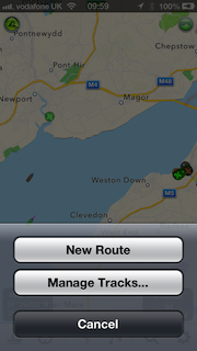
We were recently asked by someone who uses SeaNav for fishing trips if there is a way of adding locations/points of interest (POI) so they could mark their favourite fishing areas whilst at home and then navigate to them when on their boat. There is; though it might not seem obvious at first. You can use Routes and Waypoints with just one waypoint. Talking with Matt and trying to explain how to add waypoints and routes it also became clear that it is not simple to the un-initiated. So we are following up with some more detailed instructions. To add a new route you need to make sure the Sailing icon bottom left is not selected (must be gray rather than blue). You cannot create or edit a route if you are in sailing/navigation mode. To create a route tap the route button, middle of the row of icons at the bottom.
A popup will show.
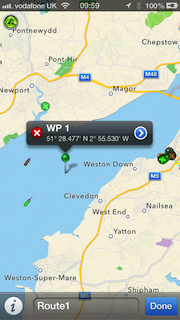
Select “New route” from the popup by tapping the button. Then tap and hold for about a second anywhere on the map to put down a waypoint/marker. Don’t worry about being precise, you can drag and drop the pin by placing and holding your finger over it , to where you want it. If you quickly tap the pin a popup will display its name (WP1) and Lat and Long with a red cross to delete it on the left (you can’t delete it if its the only pin – you can delete its route later). Tap the blue arrow on the right of the popup to change the name of the marker. You can also edit the name of the route by tapping in the name box at the bottom where it says “Route1”.
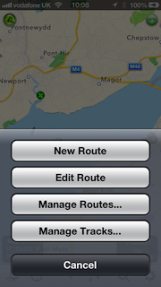
When you are done setting up your marker, tap Done, bottom right and you now have a route set up. You can of course add as many waypoints/markers to a route as you wish and you can add as many routes as you wish. After tapping Done this route will now be your active route. Tapping the route button again will let you add another route or edit your existing ones including selecting a route if you have many set up.
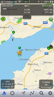
When you have a route selected and displayed and then tap the Sailing button, SeaNav will enter navigation mode and show the name, distance, bearing, Cross track error (arrow at the top on the left pointing which way to steer to get back on track and how far off direct track you are), velocity made good towards the waypoint (VMG) and Estimated Time of arrival (ETA) to the closest Waypoint/Marker as well as your course (COG) and speed (SOG), updating it in real time as you navigate. SeaNav will also sound an alert when you get close to a Marker.
We hope this helps, please let us know if it does or if you have any questions/suggestions – you can email us at help@pocketmariner.com
There is also quite an extensive user guide and FAQ in the app (tap the i button far right at the bottom) and also via this web page:-
We are excited to announce the release of our next nautical navigation app – SeaNav®
SeaNav ® lets you explore, plan and navigate your boating trips in real time and outstanding high-resolution using the latest Digital Vector Marine charts covering the US & Great Lakes or UK and Ireland.
Route Planning and real time tracking including Waypoints, SOG, COG, ETA, CTE etc.
Route and Track export, import and sharing.
Charts downloaded and stored on device so they work without mobile coverage!
Seamless fast panning and zooming across charts.
Live AIS Ship positions overlaid from Boat Beacon app.
Configurable layers; buoys, lights, depths, rocks, wrecks, anchorage areas etc.
Automatic Chart updates.
Buy once and use on both your iPhone and iPad devices. SeaNav works in high-resolution on your iPad and iPhone without having to buy an additional HD version.
SeaNav has two versions, SeaNav US which uses NOAA charts and provides complete coverage of USA and Great Lakes.SeaNav UK uses UKHO charts, and offers complete coverage for UK and Ireland. Both versions are available from the App Store on your iPhone or iPad.


")