SeaNav and an autonomous boat

We have downsized the Pocket Mariner test boat from a catamaran cruiser to a catamaran dinghy (Dart 18) and are doing our bit for Net Zero and our ears with an electric outboard.

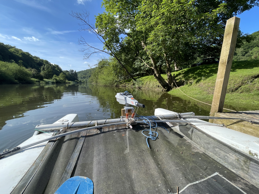
We chose the Torqeedo 1103C which has slightly more power than an e-Propulsion and also had the benefit of being available rather than on a 6 month back order. It is a revolution compared to a petrol outboard. Totally silent apart from the sound of water flowing past the hull, instant start, no oil or smelly petrol and fumes. A real joy, here is it in action on the river Wye:-

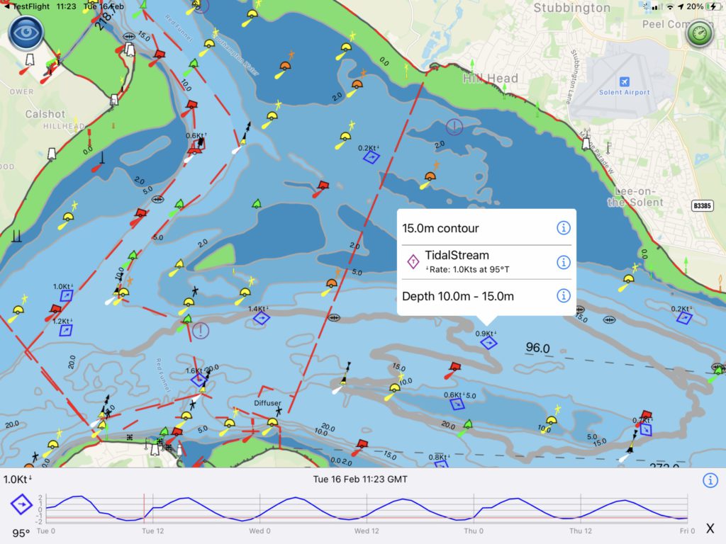
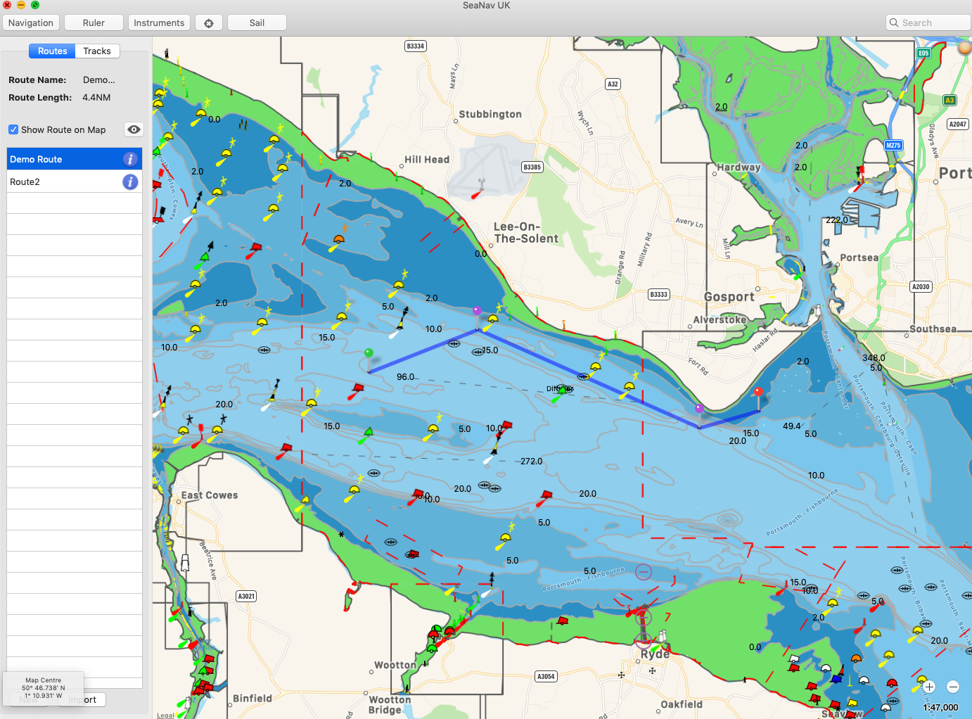
As well as using the test boat for testing our marine navigation apps we got inspired to take the boat to the next level and see if we could automate it and ultimately use SeaNav to control it to follow a SeaNav route.

Two steps:-

  1. A bluetooth LE enabled autohelm attachment to control the outboard direction
  2. Add the bluetooth driver capability to SeaNav and get it to maintain course and change course at Waypoints.

A possible 3rd step is to add a remote throttle control too so we can go fully autonomous!

This article covers step 1.

Step 1. Bluetooth iOS remote for Navico TP5000

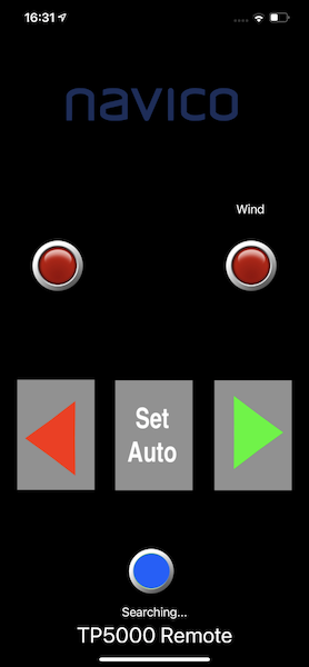
Autohelm units are very expensive ( over £400) and none offer remote bluetooth control. We couldn’t find one that supported remote NMEA0183 control either. So we bought a second hand Navico TP5000 unit off eBay and adapted it to support Bluetooth using an Arduino BLE nano33 board and 3 relays attached inside the housing to the switches. The project design, instructions and code is here https://github.com/electricpocket/autopilot. This could also be adapted to control a Raymarine Autohelm unit.

Here is the Navico TP5000 in manual mode attached to the boat and Torqeedo outboard:-

and here is the TP50000 controlled with our iPhone autopilot app:-

Next is to test this on the water and then move on to Step 2…..

Please contact help@pocketmariner.com if you have any questions or suggestions.

Tidal Streams for SeaNav

You can now view the current and predicted tidal flow rates and directions live on SeaNav’s UK and IE vector charts.

We use the official chart Tidal diamond symbol, rotating it to point in the flow direction. Blue means the rate is decreasing, red and its increasing. The diamonds update in real time on the chart. For planning tap on a tidal diamond to see the rate and direction, tap i for more information and see the rate and direction for the next 3 days on a graph at the bottom of the screen. Slide the time cursor ( or just tap at the time you want ) and all the tidal diamonds in view on the chart update as you adjust it (not just the one you have selected). You can zoom in and out of the graph timeline using pinch gestures. The Tidal Stream information is cached for up to 7 days so will work when you are out. of internet coverage as well.

The new Tidal Stream feature requires SeaNav 5.3 or later and uses official data from the UK Hydrographic Office, updated annually. A current UK & IE chart subscription is required to view the data. We hope to add Tidal Streams for other areas where available if they prove popular ( FR, NL & BE, DE… ). Please email us and let us know.

Real-time internet AIS Sharing to Navionics, iNavX, AquaMap, OpenCPN, etc. with Boat Beacon

Boat Beacon can now share its real time AIS feed from our global AIS aerial network via NMEA with other apps on the same device or on the same Wifi Network. Boat Beacon acts as a “Virtual AIS Receiver” with over the horizon coverage and is the first and currently only app out there that offers this.
Boat Beacon’s global realtime AIS coverage.
 We hope this will prove popular with folks who already have other Marine Navigation apps/charts like Navionics,  iNavX, Aqua Map and  OpenCPN etc. which support an external NMEA AIS feed but don’t have their own Internet based AIS network or feed available.
Navionics have worked closely with us on this with their Boating app  AIS feature and recommend Boat Beacon in its own category in their  Boating app – AIS Devices Compatibility Guide.
The new Boat Beacon AIS Share feature is free to trial.  If you find it useful you can use it any time when you are out boating for a small monthly or annual subscription via IAP.
You can get the latest version of Boat Beacon from the Apple App Store here and Google PlayStore here.
By the way, our own top selling marine charts navigation app SeaNav already has AIS built in as standard and if you haven’t tried SeaNav why don’t you give it a spin for free first, you can download it from here now https://apps.apple.com/app/seanav/id857841271 .
Here are some screenshots from Navionics, iNavX and OpenCPN using it.

Navionics connected to Boat Beacon on 127.0.0.1 TCP port 5353

On iOS

On Android
 iNavX on same  device ( using TCP 127.0.0.1 port 5353 )

AquaMap

AquaMap

OpenCPN running on a Mac via Wifi to Boat Beacon running on an iPhone ( TCP to 192.168.1.106 port 5353).


There are some simple step by step instructions on how to set up Boat Beacon AIS Sharing with the Navionics Boating app here:-  https://pocketmariner.com/setup-boat-beacon-share-ais-navionics/

and here is the description in our user guide:-

AIS Sharing

Share Boat Beacon’s real time internet AIS feed via NMEA with other apps on your device and on the same Wifi network, like Navionics, OpenCPN on your Mac, iNavX , AquaMap etc. so you can see live ship positions around you on their charts as well. Pocket Mariner’s AIS service is fed by one of the largest network of AIS shore receivers world-wide covering most major ports, harbours and popular coastal areas with over 60,000 live ship positions at any time. Boat Beacon acts like a virtual AIS receiver and can also share your live position via Internet AIS with other users and internet based AIS services like MarineTraffic. After purchasing the Boat Beacon AIS Sharing IAP (monthly or yearly subscriptions available) just set your other apps NMEA TCP settings to connect to the IP address and TCP port (default is 5353) shown in Boat Beacon’s AIS Share setting. If you are sharing with an app on the same device you should use 127.0.0.1 as the IP address to connect to instead of the actual device IP address so you never have to change the setting when you are on a different network. Boat Beacon must be in sailing mode when sharing with other apps on the same device so it can track your position and continually update the live AIS data around you in the background. Tap the SailBoat icon  bottom left to enable Sailing mode. In the unlikely event that you need to change the TCP port number in Boat Beacon to another number, tap on the AIS Share setting row and enter it. 

On iOS you can try it out at home when there are no boats around your location by putting Boat Beacon into Demo mode ( Settings/Demo mode) first and then set sailing mode. Make sure the other app is showing the same map location as the demo mode is. Make sure to turn sailing and demo mode off when you are done. If Boat Beacon is not displaying any ships around your location then no ships will appear in the other apps either.

On Android get a 3 day free trial to try it out when you sign up for one of the subscription options. You can cancel the subscription at any time and will not be charged anything if you cancel before the end of free trial period.

Get the latest version of Boat Beacon from the App Store from here now and Google PlayStore here.

Entering routes and waypoints with SeaNav on a Mac

Here is how to enter routes and waypoints in SeaNav Mac
Left mouse click on the chart and select “Start new route here”
Screenshot 2019-05-21 at 12.48.31.png
A green pin will be placed on the map and the Navigation panel will display on the left with the first waypoint information.
To add the next waypoint move to another point and left mouse click and select “Add waypoint here”.

A red pin will appear with a blue line (route) from the first pin.
Screenshot 2019-05-21 at 12.48.59.png
You can add as many waypoints as you require and drag and drop the waypoint markers using a long mouse select on them.

Tap the i button on a Waypoint to give it a name ( optional) and view the full lat and long position ( including when you drag and drop it) so you can set its location precisely.

Screenshot 2019-05-21 at 12.53.03.png
Click on Done when finished and you can then sail the route at any time by pressing Sail. You can also select a previously saved route, Sail it , edit it or export it.
You can add a set of existing waypoints from a spreadsheet following this blog article:-
Here’s our guide on iPhone which also has some relevance to Mac. You can also export/import routes between the iOS SeaNav and Mac SeaNav app and also view them in Google Earth.
You can view the routes at any time by tapping the Navigation tab – there is a Demo route in the Solent included with the app that you can use to play with (tap the i button to view the route details and select Edit Route) :-
Screenshot 2019-05-21 at 12.58.45.png

SailTimer Wind Instrument, SeaNav and Pebble SmartWatch

Some of SailTimer’s customers asked them if their bluetooth WindInstrument would work with Pocket Mariner’s  SeaNav Marine Navigation app and if the wind information could also be displayed on our free SeaNav Pebble watch companion app. So SailTimer asked us and now it does…
diag copy
windinstruments
The SailTimer WindInstrument is completely wireless, no power of data lines, so the install is far simpler than for other marine wind vanes.  It is the first masthead anemometer  with a digital compass built into the wind direction arrow so you get true wind direction even when docked or at anchor. It sends the wind data via bluetooth and is solar powered with 24 hour running. The WindInstrument if fully weather and waterproof (submersible) and has innovative wind cup blades design to maintain equal accuracy when sailing heeled over.

Continue reading “SailTimer Wind Instrument, SeaNav and Pebble SmartWatch”

New NAVTEX App for iPhone and iPad

Screen Shot 2016-01-13 at 16.30.45One of our AIS contributors, Duarte in Portugal, has recently written an interesting and unique marine navigation app that we thought we should let our readers know about. It allows you to view Navtex information directly on your iPhone or iPad without needing  an HF radio on board.  NAVTEX  provides navigational and meteorological warnings and forecasts, as well as urgent maritime safety information to ships.  You can download Navtex for free from the App Store here:-  https://itunes.apple.com/us/app/navtex/id1065285995 . You can also try out all the features for free for a week.

Simulator Screen Shot 28 Dec 2015 17.45.23

There is a short video clip showing what the app can do here:-

https://www.youtube.com/watch?v=wx-um26WoDE&authuser=0

and here is what Duarte has to say about his app:-

Navtex should be a requirement to any mariner, hobbyist or professional, regardless the type and size of vessel as it offers important Navigation Warnings that are safety-related while at sea.
Nearly 200 NAVTEX Radio Stations across the world form a global coverage network transmitting messages either in 490kHz, 518kHz, 4209.5kHz, 424kHz and 486kHz. 

At sea, safety is everything so our Navtex App will fetch the latest NAVTEX messages issued by the several official entities and present them to you whenever you want. 
You don’t need to connect your iPhone/iPad to any HF Radio. Only an internet connection is required. Synchronize and within seconds you have the worldwide updated Navtex information in your pocket.
You may select any of the available NAVTEX stations in the App and check their transmission schedule, frequencies, local data and latest important transmitted messages.

The Navtex Navigational Warnings will be collected from the internet and will be stored on your device, so you can read them even if you are off-line.

In Brazil, Australia and New Zeeland Navigation Warnings are not broadcasted via NAVTEX. However, this App will still fetch the latest Navigation Warnings from those regions and show them to you.

Additionally, you can also subscribe to APRS weather that is broadcasted by ham radio enthusiasts all over the world. It is a good backup system to gather weather information in case of failure of the vessels’s primary systems.

ActiveCaptain with SeaNav and BoatWatch


ActiveCaptain750x1334ss-80


The latest versions of our SeaNav and BoatWatch iOS apps now include the fabulous ActiveCaptain database providing on and off-line access to information on tens of thousands of marinas, anchorages, hazards and local knowledge (bridges, locks etc.) , as well as reviews from other boaters, shown geographically on marine charts, satellite images, or street maps. The ActiveCaptain coverage is global. There is information on Marinas and Harbour side restaurants etc. from around the world including the US, Canada, UK, France, Spain  etc. . If you aren’t already signed up for ActiveCaptain you can do it for free in a few seconds here:-

https://activecaptain.com/register.php

We found Jeff at ActiveCaptain really supportive and helpful on the integration with his data and had some lovely comments back from him on how well we did it too “The Pocket Mariner developers have been exceptional to work with. They are real boaters who get out on the water with their own tools.” Jeffrey Siegel, ActiveCaptain.

We look forward to adding more features and the ability to post reviews from our apps too in the near future.

Hoegh Osaka – replay of grounding in 2 and 3D

osaka-ship_3157884b


We used our AIS Fleetwatch service  to replay the final moments before the Hoegh Osaka was deliberately grounded on Bramble Bank in Southampton. You can watch the speeded up replay on 2D and 3D here http://youtu.be/5fW_LRDWUPo . Interestingly our replay correctly shows the ship heading onto the bank in a Northerly direction before she grounds. Other replays incorrectly show her moving sideways onto the bank. It may be that the gyros failed on the ship just before she started listing badly resulting in the list and an incorrect ship’s heading being sent.


New AIS Aerial at Davidstow Airfield, Cornwall

As part of the ongoing work to improve our global AIS coverage we have installed a new AIS aerial to provide better real time coverage for the seas around Cornwall in the UK.  There is a disused airfield at Davidstow. It was Coastal Command’s highest airfield in the UK at 300m (1000′) above sea level; a perfect place to get a long range view of the surrounding sea,  to the North, West and South of Cornwall.  We used a Digital Yacht AIS Net base station for the AIS receiver with a Shakespeare 6db AIS tuned aerial. There is no internet connection at the museum so we used a Huawei E3551 3G dongle and the excellent EE 3/4G data service to backhaul the AIS data to our servers.  You can check the live coverage from the new aerial here:-  http://boatbeaconapp.com/station/5353

Here is my son installing the aerial on the tower at the airfield.

image1


The DY AIS receiver hooked up at the base of the aerial.


image2


and live ships –  10,000 square miles of coverage including two major ports at Falmouth and Plymouth 🙂

Screen Shot 2014-10-07 at 16.56.24

Many thanks to Steve at Davidstow Airfield and Cornwall at War Museum who is kindly letting us use his tower to mount the aerial on  (giving us another 12m (40′) of elevation 🙂 . The museum is very well worth visiting if you are in the area and even if you are not.