Danish Vector Marine charts for SeaNav

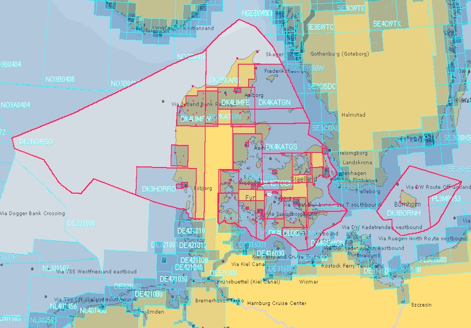
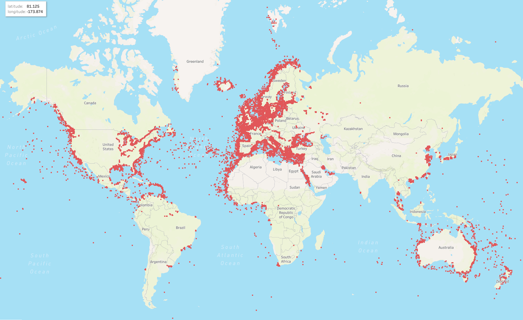
Danish charts are now available in SeaNav. The vector marine charts are licensed and derived from the official Danish Hydrographic Office data. These cover the whole of the European Danish waters. Please see the coverage map below.

Coverage Map for Danish charts:

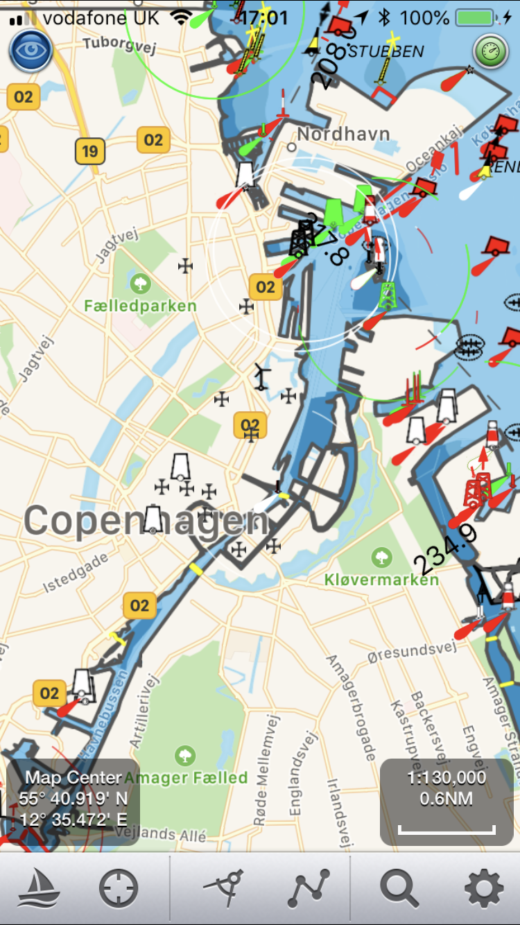
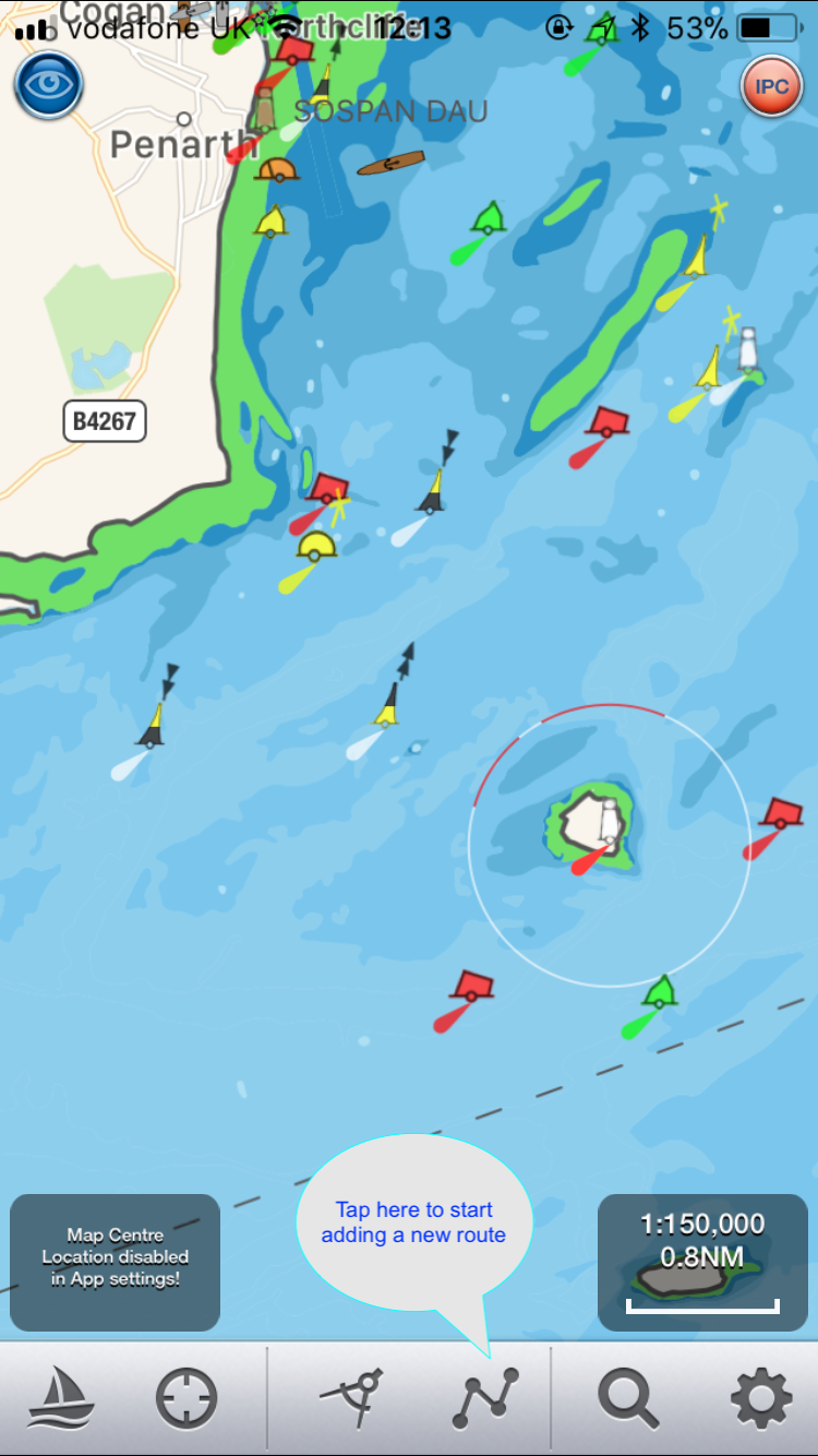
Here is a close up on the iPhone showing the approach to Copenhagen. Being  vector charts, all chart objects are tappable to give more information. This includes names and types as well as distance and bearing from your position. Sectored lights also show the colours, range and sector angle when tapped.

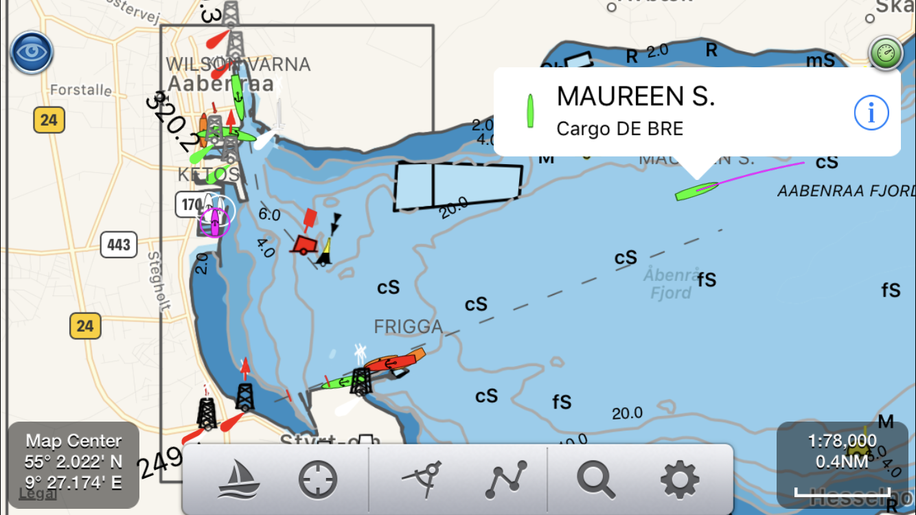
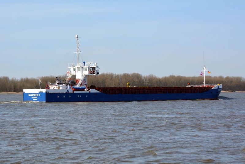
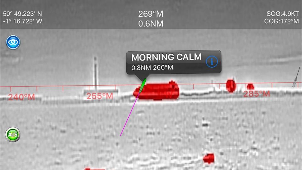
SeaNav also has complete live Ship (AIS) coverage for the whole of Denmark. Here is an example in the Aabenraa Fjord showing the Maureen S. just departed on her way to Germany.

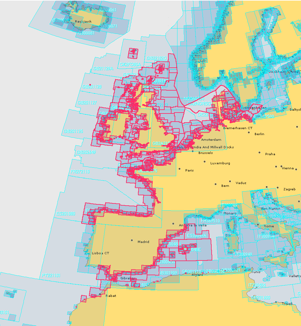
SeaNav now has UK, IE, NL, BE, FR, DE, ES, US and CA charts available with complete coverage across the English Channel  and we now have continuous coverage from Nantes in France through Belgium and the Netherlands, across Denmark and Germany including the German inland waterways.  Current European chart coverage is outlined in red below.

Norwegian charts are also available for free in SeaNav’s sister app, NaviPlotter by Nautisk (same app as SeaNav but with different branding and additional Norwegian charts from the Norwegian HO).

The Danish charts and others can be obtained via a simple In App Purchase (IAP ) in SeaNav and SeaNav UK. All SeaNav charts are regularly updated while you have a valid chart subscription in place. You can read more about SeaNav and how to download our free version here –  SeaNav

How to import lots of Points of Interest using SeaNav POI csv to kmz converter

SeaNav lets you add individual Point of Interest (POI) at a tap of the screen in the app but what about importing a list of POIs that you already have? We have set up a service to make creating SeaNav Points of Interest from a list of latitudes and longitudes easier and faster. Simply upload a CSV file ( spreadsheet comma separated values) of the POIs using this web link

https://seanav.net/charts/poi_upload.form.php

A SeaNav ready kmz file will be downloaded to your desktop which you can then share and import to SeaNav via email or Dropbox. You can also view the kmz file in Google Earth.
The format for the csv file is very simple and contains one or more lines with:-
name,type (integer 1-6),description,longitude(DD.DDD),latitude (DD.DDD)

e.g. Bass here,3,Good spot,-0.473850,50.291134
The POI types are:

  • 1.  general
  • 2. hazard
  • 3.  fishing spot
  • 4.  diving location
  • 5.  race markers for club racing
  • 6.  favourite harbour or anchorage spot
  • 7.  bridge

These set the POI icon to be used as well.

The description can be html markup including an image link e.g.

“<img src=’http://myserver.com/mypicture.png’><br>Inlet</br>”

Be sure to wrap html descriptions in quotes as above.

There is more about SeaNav POIs here

SeaNav Favourite Places – Share POIs and Routes

and we have a large database of existing and publicly shared POIs including Marinas and Harbours that you can view and send to SeaNav here :-

https://seanav.net/charts/pois


Alexa Boat Beacon skill – talk with your boat

Boat Beacon now works with the amazing Amazon Alexa and Echo devices using our free Alexa Boat Beacon skill.

“Alexa, ask Boat Beacon my position”

“Sarita is travelling North East at 6 Knots in the English channel currently 5 miles south west of Plymouth”.

Or ask for “exact position” and hear : “Sarita. Latitude 52 degrees 1 minute North, Longitude 1 degree 52 minutes 34 seconds West, course 55 degrees true, speed 5 Knots.”

You can see a short 19s video clip of the Boat Beacon Alexa skill in action here :-http://boatbeaconapp.com/BoatBeaconAlexa.mp4

Just ask Alexa to register your Boat Beacon 9 digit BBSI number (without the BB prefix) to associate the Alexa Boat Beacon skill with your own Boat Beacon app and put Boat Beacon in transmit mode (sailing)  to update your location, speed and course in real time.

“Alexa, ask Boat Beacon to register 617648992”

Response: “Boat Beacon BBSI 617648992 has been successfully registered. You may now ask for its position”.

You can find your unique Boat Beacon BBSI number at the bottom of Settings/My Boat Details in the Boat Beacon app on your iPhone or Android device. See the iPhone screenshot below.

Friends and family can also use the Boat Beacon Alexa skill to follow your progress  when you share your Boat Beacon BBSI 9 digit number with them.

We have lots of other ideas up our sleeves for the Alexa Boat Beacon skill if it proves popular. “Alexa, ask Boat Beacon to alert me on CPA” , “Alexa, ask Boat Beacon to tell me if the wind exceeds 6 knots” and would love to hear your ideas. And if you want to know where another boat is by name or MMSI number you can use our free Boat Watch Alexa skill

Get the free Boat Beacon Alexa skill here now:-

https://www.amazon.com/gp/product/B07BDN2W6X

How to find your BBSI number

Open settings in Boat Beacon on your iOS or Android device, select My Boat Details and scroll down to the bottom to see your Boat Beacon Id  (BBSI). Use the 9 digit number (without the BB letters ) to connect Alexa with your iOS or Android device.


Latest Global AIS Coverage map

Here is the latest snapshot of our worldwide AIS coverage broken down into 0.25 degree squares. Zoom in to see the detail. We have recently added coverage for the whole of Finland, Norway and Denmark, the Black and Red Seas, Istanbul, The Suez canal and the Panama canal (East) and mucg improved coverage around the UK and IE. We are now showing over 50,000 live ship positions per hour; amongst the best in the industry. We only use real time data. We do not use satellite data which can be several hours behind real item like some other AIS services do.

We also record all the AIS messages and store them for ever. We have global time stamped AIS data going back to 2014. If you would like to use our live or historic AIS data please contact us at support@pocketmariner.com


How to create and edit a route with SeaNav

Here is a quick guide on how to add a new route in SeaNav

Tap the route button at the bottom of the screen.

Long press on the chart where you want to add a waypoint and tap “Add Waypoint here” on the popup.

Add the next waypoint in the same way

And a third and as may as you want and then tap Done when you have finished. You can move the waypoints you have already added using a long press on one to select it and then dragging it to the desired position. You can also edit the exact position (latitude and longitude) later in the Manage Routes view.

After pressing Done the route will be shown on your chart. You can then start sailing the route or tap the Route icon again to Edit or Manage your routes.

Tap Manage Routes to see all your routes and select a different one of manually edit the current one.

Tap the i button next to a route to see more detail. You can also edit the fields on the detailed view. For instance change the route name from Route2 to Cardiff. Tap the i next to a Waypoint to add names for the waypoints and edit their precise latitude and longitudes. You can enter the latitudes and longitudes in most formats ( e.g. Degrees Minute Seconds, Degrees Minutes and Decimal Degrees (e.g. 52.1345) ) and you do not need to enter the degree, minute or second symbols. Here are some examples:-

DM : 28° 52.634 ́ N can be entered as 28 54.634

DMS :28° 52′ 48″W can be entered as 28 52 48W or   -28 52 48

This view also lets you export the route via email or dropbox to share with others, keep a backup or share with your iPad or Mac (tap the box with an arrow going upwards from it).

If you have any questions please email us at support@pocketmariner.com or view the SeaNav User Guide here:- http://seanav.net/help.html

Charter a yacht with Click&Boat – the Airbnb for boats

When I am travelling for business to places near the sea I always want to be able to charter a yacht to stay on instead of having to search for a hotel – I  just prefer the peace that this offers. I was actually able to manage it once while visiting Barcelona for a very large conference. You’d typically think that this would be just as, or if not more expensive but I was able to save a fortune compared to the cost of the regular hotels in the city. On top of this I  had a fantastic  sea view. Truthfully, at the time it was quite difficult for me to find and arrange. Although not any longer. I have discovered this great new website for yacht charter , Click&Boat.

The company is the boating equivalent of Airbnb. Boat owners create listing for their boats depending on their availability, they choose the price, dates and can offer charters with or without a skipper. Users simply enter in your search requirements, browse the range of boats available and take their pick. Once they have requested the boat they would like they are able to talk directly to the boat owner to make the final arrangements.

So in my case; I needed to stay in Southampton for a Boat Show. The exhibition hotel was over £300 a night and fully booked so instead I found a yacht to charter on  Click&Boat within walking distance of the show and for less than half of that price.

I am also thinking of putting my catamaran Sarita on the Click&Boat website – fancy a stay on the beautiful river Wye with power and water to hand?

Sarita alfoat again.

Click&Boat have more than 20,000 yachts listed on their websites and over 40,000 customer reviews. They are the European authority on peer to peer yacht charter and offer you a secure service.

Go take a look.

Augmented Reality with FLIRONE

Augmented Reality with FLIR ONE

MORNING_CALM_BB_AR_FLIR_IOSPocket Mariner collaborated with Practical Boat Owner to successfully complete a demanding night time sea trial of our popular marine navigation apps, SeaNav HD and Boat Beacon with the  FLIR ONE Thermal Imager for iOS; a new, low cost , infra-red thermal imaging camera for the iPhone.  The FLIR ONE makes thermal imaging affordable and accessible to a much wider audience at a fraction of the cost of the higher end marine IR imaging devices. Pocket Mariner have ingeniously integrated the live thermal image with their widely acclaimed iOS Augmented Reality mode providing identification, distance and bearing of the ships and Aids To Navigation in view at night and in fog.  We wanted to see how well and how far off we could spot ships via their infra-red signature and if the FLIR ONE could help with searching for a Man Overboard (MOB).

Practical Boat Owner, the UK’s leading boating magazine, bravely deployed their editors, David Pugh and Ben Meakin, together with Ben’s Impala 28 yacht , “Polly” and intrepid “Woman Overboard” volunteer, Laura, along with Pocket Mariner’s CEO, Steve, on a pitch black night in Southampton water.

Here’s what we saw.

Continue reading “Augmented Reality with FLIRONE”

Boat Beacon transmitting live internet AIS for over 200 boats world wide

Boat Beacon allows folks to share their position and course in real time with other users and folks back home using just their iOS or Android device. Their position is also visible on other internet based AIS tracking services such as SeaNav and our free Boat Watch app and the very popular MarineTraffic service. Use your VHF assigned MMSI number or request a free internet AIS MMSI through us to be visible on the public AIS internet services. A lot of the CoastGuards use MarineTraffic so you can be visible on their systems too. For instance Boat Beacon is used by the Australian Voluntary Coast Guard for automatic tracking.

With cellular data  coverage around most of the popular coasts extending out to 12NM or more the range is excellent. Here are the Boat Beacon boats out around the world right now:-

Clicking on an individual boat shows more details and you can also use view their track (layer control top right).

All the Boat Beacon boats currently transmitting their position can be seen here:- http://boatbeaconapp.com/kml/findlive.php

Our Boat Beacon app also tracks all the boats and ships around you in real time via internet AIS and uniquely provides proven constant collision avoidance detection, even in the background. Other popular features in Boat Beacon are our AIS augmented reality view, anchor alarm, theft alarm and MOB features. Boat Beacon is available now in the App Store for iPhone and iPad and in the Google Play Store for Android phones and tablets.

SeaNav Augmented Reality goes Vertical

Never get stuck under a bridge again! We are pretty excited about the unique Augmented Reality (AR) feature we have just added to our popular SeaNav  iOS marine navigation app. Set a SeaNav POI (Point of interest) marker for a bridge (or cable) on the SeaNav map view, set your boat’s Air Draft in SeaNav’s settings (5.5m for our test boat with its mast down) and see this as you approach the bridge in SeaNav’s AR view on your iPhone or iPad:-

This is one of the 3 low bridges we have to pass under on a tidal river around High Tide (12m at Springs) to get out to sea from our mooring. With the horizon line lined up with the sea level at the bottom of the bridge, the bold red line shows the height of your boat at the bridge. With the latest iOS camera APIs we can get the FoV parameters for any iOS device which allows us to do the relative drawing. The SeaNav POI feature comes included with our free version of the SeaNav App, Air Draught is now included as part of the SeaNav Pro In App Purchase feature ($10) which adds Augmented Reality and live ship AIS positions.

SeaNav Favourite Places – Share POIs and Routes

We have received a lot of requests from our SeaNav users wanting to mark a favourite fishing or diving spot, beautiful anchorage etc. You can now do this in SeaNav with the new Favourite Places feature.  Add custom markers to your charts for places you want to remember, share with friends or even better share with the rest of the SeaNav community. There are several types now available:-

  • fishing spots
  • diving locations
  • favourite anchorage spots
  • hazards
  • race markers for club racing
  •  information/reminder
  • bridges

Set up a series of race marks or route for your local club and share with all. Update them in an instant if there is a change in the wind. Add a reminder for which VHF channel to call a marina or VTS. Use your local knowledge to mark a hazard to warn other users. Let people know about a service or marina that is available and provide recommendations/ details/ contact numbers in the description. Note the clearance under a low bridge that is not marked on the chart.

You can add a title, description and a photo for a POI. You can backup/share your POIs via email and dropbox and now you can also share POIs straight from the app with the whole SeaNav community via the SeaNav web page  SeaNav Routes and POI service . You can share routes and download them from the SeaNav pages too.

You can read more about how to use the POI and Routes features in our SeaNav user guide on the web or in the App under Settings/Help, FAQ and Demo.