Check out the pictures these guys are posting on their Twitter feed…
https://twitter.com/
Sheerness Lifeboat!

Check out the pictures these guys are posting on their Twitter feed…
https://twitter.com/
Sheerness Lifeboat!
Wales, UK – Pocket Mariner’s recently launched SeaNav app, with versions for both the US and UK/Ireland, has been updated to offer a more complete charting and navigation toolkit for boaters. To improve navigation and collision avoidance when out of reach of cell phone coverage, SeaNav — together with Pocket Mariner’s Boat Beacon app — can now also use on-board live VHF AIS data feeds. The app also now enables sailors to jump directly to specific locations using latitude and longitude searches and has been extended for use on iPods as well as iPhone and iPad.
SeaNav was designed to enable boaters to explore, plan and navigate their boating trips in real-time and high-resolution using the latest up to date Digital Vector Marine charts covering the US coastlines and Great Lakes or the UK and Ireland. Pocket Mariner has successfully completed sea trials of the new local AIS feature with Lowrance, Simrad and B&G’s GoFree™ wireless systems, as well as with easyAIS and Digital Yacht.
Robert Langford-Wood Product Manager for GoFree Technology said: “Applications such as SeaNav and Boat Beacon, when combined with GoFree wireless, allow boaters to make the most out of their Lowrance, Simrad and B&G chartplotters and AIS systems away from the helm. It means that every member of the crew can have a navigator’s eye view, increasing safety and enjoyment out on the water – a great innovation!”
SeaNav works best when paired with Pocket Mariner’s Boat Beacon, which has become an enormously popular app among sailors for its simple-to-use location sharing and real-time “Map View” of both the user’s and other nearby boats via AIS. Together, SeaNav and Boat Beacon provide a powerful set of charting, navigation and location-sharing tools. While Boat Beacon provides SeaNav with its AIS data and alarms, Boat Beacon gets marine charts and routes from SeaNav. The two apps share hot-jump buttons that ensure they are both on the same location and at the same zoom level on the map.
Key features of SeaNav include:
• Route Planning and real time tracking including Waypoints, SOG, COG, ETA, CTE etc.
• Route and Track export, import and sharing.
• Charts downloaded and stored on device so they work without mobile coverage!
• Seamless fast panning and zooming across charts.
• Live AIS Ship positions overlaid from Pocket Mariner’s Boat Beacon app.
• Configurable layers; buoys, lights, depths, rocks, wrecks, anchorage areas etc.
• Automatic Chart updates.
SeaNav has two versions, SeaNav US which uses NOAA charts providing complete coverage of USA and Great Lakes and free chart updates for life. SeaNav UK uses UKHO Admiralty charts and includes the complete set of charts for the UK and Ireland plus a year of free chart updates in the one-off price. New versions of the app with charts for other countries and regions are in the works.
Both versions are available from the App Store for iPhone, iPad, and – in this latest version – on an iPod touch, for US$9.99 and £9.99 in the UK.
For more information, visit PocketMariner.com. or email steve@pocketmariner.com
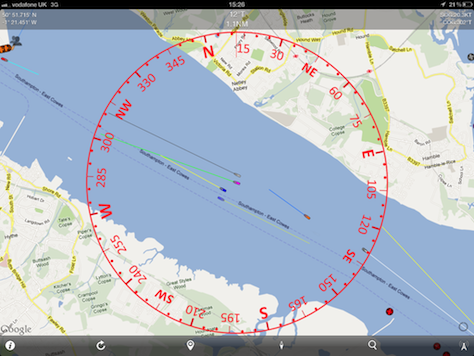
Live screenshots testing Boat Beacon in the Solent
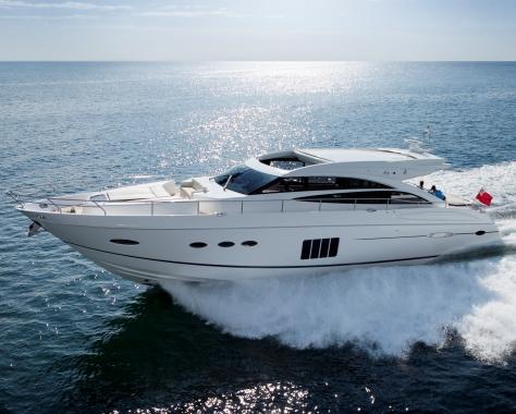
Our test boat!
Live view from Boat Beacon: the test boat is the purple boat in the centre, while the Ferry is blue to port
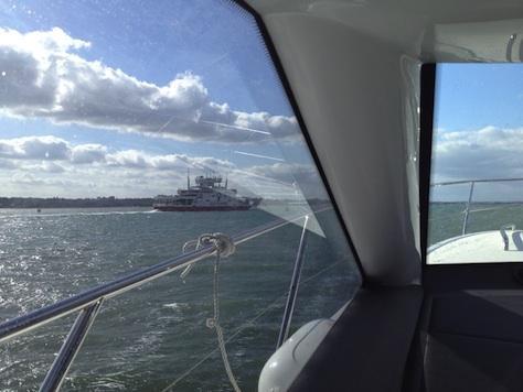
View of the blue target (Ferry) from bridge of our boat.
About Navico: Navico is currently the world’s largest marine electronics company, and is producing products under leading marine electronics brands: Lowrance, Simrad and B&G. Navico has approximately 1,500 employees globally and distribution in more than 100 countries worldwide. www.navico.com
We now have a video ad for Boat Beacon, amazing what these creatives can pack into 12s of video.
Click here to see the ad.
We are excited to announce the release of our next nautical navigation app – SeaNav®
SeaNav ® lets you explore, plan and navigate your boating trips in real time and outstanding high-resolution using the latest Digital Vector Marine charts covering the US & Great Lakes or UK and Ireland.
Buy once and use on both your iPhone and iPad devices. SeaNav works in high-resolution on your iPad and iPhone without having to buy an additional HD version.
SeaNav has two versions, SeaNav US which uses NOAA charts and provides complete coverage of USA and Great Lakes.SeaNav UK uses UKHO charts, and offers complete coverage for UK and Ireland. Both versions are available from the App Store on your iPhone or iPad.

We were asked if we could help out with a new Australian Coast Guard radio log system using Boat Beacon. The system is now live and made it onto Australian TV.
Boat Beacon being used with the Australian Coast Guard.
N.B. The clip where they accredited Pocket Mariner with making Boat Beacon is on the cutting room floor unfortunately – you have to love reporters 🙂

Pocket Mariner will be attending the AIS Summit in Hamburg, Germany.
Looking forward to meeting the Marine Traffic and AIS-Hub folks along with the rest of the world-wide AIS community.


Captain Ian Engelbrecht and First Mate Ibolya Palko from Worldwide Yacht Deliveries sent us a report today on how Boat Beacon helped them when they were caught in fog 4NM off the South African coast. They were sailing a Jaguar 36 Catamaran on a 900 mile, 12 day voyage from Cape Town to Durban, South Africa. There is a map showing their planned route to the right. They had just passed Hamburg on their route up the East South African coast when they lost visibility. Their primary AIS system had failed. They did the right thing and diverted in close to shore to find shallow waters and avoid any commercial shipping (see the track map below). They were hoping there wouldn’t be anything else so close in. They decided to power up Boat Beacon on their Android smartphone and leave it running to keep a look out.
Boat Beacon alerted them to a container ship, also close in, going in the opposite direction! At a range of 21 NM ( well over the normal VHF AIS horizon) Boat Beacon gave them plenty of time to assess the situation and take the necessary avoiding action.

They also had some very useful feedback. Having no visibility and due to the specific courses involved, they weren’t too sure on how the Closest Point of Approach (CPA) would pan out. In other words what would the CPA be in relation to their vessel – port or starboard? That made it difficult to decide on the correct avoiding action to take. Captain Iain Engelbrecht asked if we could add a new feature to Boat Beacon to give the bearing of the closest point of approach with respect to one’s own boat (e.g. 0° is dead ahead, 90° to starboard, 270° is to port etc.).
Captain Engelbrecht was impressed by Boat Beacon’s real time performance – that may have saved their lives – and our immediate response to his suggestion. We are now adding the new CPA Bearing feature, continuing Pocket Mariner’s commitment to providing useful, professional and affordable aids to navigation and safety.
The iPhone 5 had a nice surprise up its sleeve for Compass Eye. The camera on the iPhone 5 has a 4 fold increase in low light ability (iso 3200). Unfortunately Apple did not make this available to existing apps out of the box. You have to specifically request the function to be enabled within your app on iOS 6. Yesterday I did just that and tested a new version of Compass Eye on the iPhone 5 against the iPhone4S at dusk – and the results speak for themselves:-
I was trying to take a bearing on the Dovecot (white with pointy roof) – bit like a North Cardinal 🙂

This is pretty close to how the scene looked to the naked eye too (admittedly non-light adapted). Can you see the Dovecot?
Below is the same scene taken on the iPhone 5 , 28s earlier. Bearing acquired!

I continued taking photos with the iPhone 5 until they matched the iPhone 4 photo at 17:13:59. Even 10 minutes later the iPhone 5 was better than the earlier iPhone 4S photo and I could still just about take a fix on the Dovecot. This could be a real advantage.
A new version of Compass Eye (2.0) is now available in the iTunes store that takes full advantage of the new camera on the iPhone 5 and also has an automatic night vision mode to help maintain your dark adaption.
We recently received an excellent review of Boat Beacon in the German Yacht magazine including some great screen shots. It generated a lot of interest with German boaters.

I wrote to the author to ask if we could use his screen shots in the iTunes store. We received a lovely reply:-
“I am the author of the review at yacht.de. I bought and tested the app on a voyage from Emden (western Germany) to river west of Hamburg – and I was very impressed by the app. We sailed the whole night through with a lot of wind and high waves. My father was with me on board, his first time on the north sea – and he got seasick the moment we left sheltered water. So I sailed singlehanded and Boat Beacon was a great help. As the boat has no AIS-System attached to the plotter, it was very helpful to have it on the iphone. Also to be able to find out in which direction the other ships were heading when I saw us on collision course. The friends and family followed our progress at home on the computer. One friend even followed us sailing up the river Oste and sent me the phonenumbers for the bascule bridges the moment we reached them.”
BoatU.S. have reviewed Boat Beacon and lists it first of the 4 Best Apps To Keep You Safe On The Water