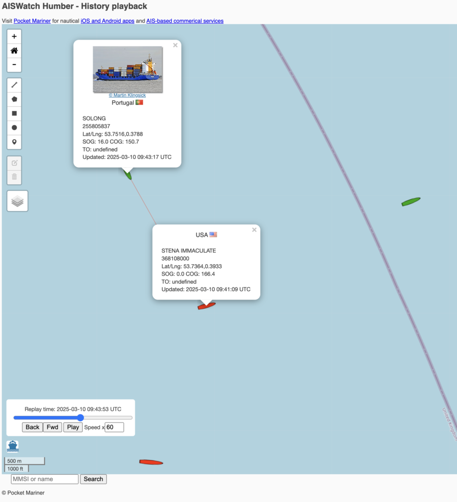
We monitor the Humber Windfarms with our AISWatch service and captured the collision today between Solong ( cargo ship in green) and the Stena Immaculate ( oil tanker in red).
You can watch the AISWatch replay of the incident in 3D here:-

We monitor the Humber Windfarms with our AISWatch service and captured the collision today between Solong ( cargo ship in green) and the Stena Immaculate ( oil tanker in red).
You can watch the AISWatch replay of the incident in 3D here:-
Pocket Mariner’s real time AIS data and photo API service has been selected by Transas , a global leader in marine navigation systems, to use with their iSailor iPhone and iPad app. The latest version 1.7.0 of their app now provides a real time map view of ships around you with instant details including name, range and bearing together with a photo of the ship to help you recognise it.
You can get the latest version of iSailor from the app store now
 Mikhail Andrianov, Product Manager at Transas says “We are really excited to provide our Transas iSailor users with live AIS data on their charts via the Internet. Pocket Mariner’s live AIS API, SDK and sample code made integration with our product easy and fast. This option makes it possible to show on charts the next AIS target types: AIS Class A, AIS Class B, AtoN (Aids-To-Navigation, virtual or real), Shore Base Stations. This functionality will be useful for users of different kinds: from sailors, boaters or water tourists, – who have no AIS Class B or receivers on board to ship owners, dockers and marine logistics personnel, who need to monitor vessel traffic in a given area. To use this functionality, you will have to have WiFi, 3G or 4G/LTE internet access on your Apple device.” Steve Bennett, Pocket Mariner’s CEO commented: “This is another great endorsement of Pocket Mariner’s “real time” AIS data service and API’s that we use to power our own Marine Navigation Apps and we look forward to providing additional AIS data services enabling Transas’ iSailor users to share their boat’s position and course in real time using our internet AIS transmit and track api’s”.
Boat Beacon now allows you to use AIS and GPS NMEA data directly from an AIS receiver and GPS on-board your boat via WiFi (over UDP or TCP) or Serial(USB). Boat Beacon seamlessly combines this with the AIS information it receives over the internet. If you travel outside mobile internet coverage or in an area where we don’t have good coverage from a local shore station, Boat Beacon can now continue to work displaying live ship data, calculating Closest Point of Approach (CPA) with alarms etc. from your VHF AIS receiver or AIS enabled VHF radio. On Android you can connect the NMEA serial or usb output from an AIS receiver or connect via WiFi. On iPhone you need to use WiFi. Here are some of the AIS receivers we have tested with Lowrance, Simrad, B&G, Digital Yacht, Comar NMEA-w2-Wifi, Weatherdock EasyAIS, Chetco Digital SeaSmart , dAISy AIS, Navico GoFree, Quark AIS (dual channel and usb stick) etc. More information on how to hook all this up is given below.
If you already have AIS data available over Wifi on board then just enter the UDP port number (or ip address and port number for TCP) for the source and Boat Beacon will start using the data. With Navico GoFree and iPhone/iPad this is even more simple as there is a “GoFree” connect button in settings – just press and go. If you only have a usb or nmea output available you will also need a serial or usb to internet or Wifi adaptor. They range in price from $50 to $200. This is one example we have tested with at the $70 level – USR-TCP232-40
Here are some specific instructions for connecting Boat Beacon on Android to GoFree – http://pocketmariner.com/?p=1538
Boat Beacon will automatically launch and use local AIS data (and GPS if available) when a USB cable is plugged in between the AIS receiver and your Android device. You can set the USB mode on or off in settings in Boat Beacon.
For an Android NMEA 0183 connection you will need the following:-
You can get Boat Beacon from the iTunes or Android stores – Boat Beacon
Our unique AR view mode allows you to view buoys, lights, ships, waypoints and track overlaid on your iPhone or iPad live camera view. With “AR LockOn” you can select a target on the chart and then be guided to it in the AR camera view.
Find that ship on the horizon and instantly see its name, range and bearing.
Spot the next marker buoy.
Tap the “eye” icon at the top left to switch AR mode on, then tilt your device up to see a live camera of the scene and boats around you. As you turn round and view buoys and ships, their name, range and bearing will popup when they are in the center of the view. You can also tap on them to get more information. Tilt back down to see the map view. Tapping the “eye” icon again turns AR mode off. You can pinch to zoom the map or camera views.
In AR mode our unique “AR Lock On” feature lets you select a ship or buoy on the map view and then easily locate it in the Camera view using a grey arrow to tell you which way to turn to spot it when its not directly in view. Your course (yellow line) and route to next waypoint (blue line) will also be visible overlayed on the camera view.
Ships are color coded based on their type e.g. Sailing boats are white, Pleasure Craft magenta, etc. See the Map Legend for full details. A vector points forward showing where each boat will be in 2 minutes time based on its current Speed and Course. Ships move in real time across the map and in the AR view. Tap on a ship or buoy to get more information and tap on the right arrow to get even more including speed, course, distance, bearing, picture etc. The horizon is set by the zoom scale of the chart view – e.g. zoom out on the chart view to see further out in the Augmented reality view.
AR photo from the Isle of Wight ferry.
We had some great feedback from one of our users, Ken, in Southern California:-
I have now been using Boat Beacon in the southern California waters for the past few months and really enjoy the visibility it provides me. Just this past weekend, my Yacht Club had a large cruise over the 4th in Catalina and in my trip over, I had a cargo ship that, based on Boat Beacon CPA data, going to get really close. I called the ship, by name, on VHF Channel 16 and based on the conversation, he changed course, which again we had a conversation with him telling me what he had planned to do etc.
It is exactly that type of data that made my trip along with a lot of others.
My question is; I have an assigned MMSI and Transmitting from the iPad, I “see” the ships, do they “see” me on their shipboard system? I know I can be seen on ship finder, Marine Traffic, but not sure if they see me in real time on their system.
BTW; a number of my club members who were in transit had heard my call and discussion and came away impressed with what Boat Beacon can do. A number of them have already downloaded it onto their apple IOS and Android devices.
In answer to Ken’s question, if you are only transmitting your position using Boat Beacon then the ships will not be able to see you on their VHF AIS Systems. However many of the Coast Guard stations and Harbour/Port Authorities around the US, UK and Australia do now combine internet AIS feeds with their local VHF AIS data, so there is a good chance you will be showing up on their screens.


Captain Ian Engelbrecht and First Mate Ibolya Palko from Worldwide Yacht Deliveries sent us a report today on how Boat Beacon helped them when they were caught in fog 4NM off the South African coast. They were sailing a Jaguar 36 Catamaran on a 900 mile, 12 day voyage from Cape Town to Durban, South Africa. There is a map showing their planned route to the right. They had just passed Hamburg on their route up the East South African coast when they lost visibility. Their primary AIS system had failed. They did the right thing and diverted in close to shore to find shallow waters and avoid any commercial shipping (see the track map below). They were hoping there wouldn’t be anything else so close in. They decided to power up Boat Beacon on their Android smartphone and leave it running to keep a look out.
Boat Beacon alerted them to a container ship, also close in, going in the opposite direction! At a range of 21 NM ( well over the normal VHF AIS horizon) Boat Beacon gave them plenty of time to assess the situation and take the necessary avoiding action.

They also had some very useful feedback. Having no visibility and due to the specific courses involved, they weren’t too sure on how the Closest Point of Approach (CPA) would pan out. In other words what would the CPA be in relation to their vessel – port or starboard? That made it difficult to decide on the correct avoiding action to take. Captain Iain Engelbrecht asked if we could add a new feature to Boat Beacon to give the bearing of the closest point of approach with respect to one’s own boat (e.g. 0° is dead ahead, 90° to starboard, 270° is to port etc.).
Captain Engelbrecht was impressed by Boat Beacon’s real time performance – that may have saved their lives – and our immediate response to his suggestion. We are now adding the new CPA Bearing feature, continuing Pocket Mariner’s commitment to providing useful, professional and affordable aids to navigation and safety.
by Steve Bennett, Captain, Pocket Mariner.
I sail a 30 foot Catamaran in the Bristol Channel, one of the most challenging areas of water in the World due to its high tidal range, currents and sandbanks – see http://www.bcya.org.uk/content/sailing-bristol-channel .
As with sailing in any waters, you need to keep in mind ports of refuge (most harbours dry), keep an eye on the weather (the channel faces West or South West, the direction of the prevailing winds) and keep a careful eye open for the very large vessels that use Bristol, Milford, Cardiff and Swansea.

With a following tide of up to 8 knots these vessels can have a speed over ground (SOG) of over 25 knots (30 mph!) – 75,000 Tonnes approaching at 30mph! Judging their position versus yours as you approach the narrow Channel under the Severn Bridge is challenging even in good visibility – in poor it’s beyond scary! It’s vital you keep out of their way because they can’t turn or stop quickly! At 25 knots they can appear from over the horizon in less than 5 minutes. Survival depends on you spotting them and getting out of the way. Even if they could see you they probably couldn’t avoid you in time – you just “don’t want to mess with them”!
The International Maritime Organization‘s (IMO) International Convention for the Safety of Life at Sea (SOLAS) requires AIS to be fitted aboard international voyaging ships with gross tonnage (GT) of 300 or more tons, and all passenger ships regardless of size. AIS works a bit like radar, but better. Ships continuously transmit their details and position and can be displayed on a live map display.

The Ship AIS units cost thousands of dollars. Small AIS receivers are available for around $400 which will allow you to show these boats on a computer screen including their course, speed and their MMSI – Marine Telephone Number – so you can call them up on VHF radio. But, that requires a large outlay and a computer screen or an even more expensive dedicated unit or Chart Plotter.
Worse than that there is also the horizon problem. An AIS receiver can only see as far as the horizon. For an aerial mounted at deck height as many are, the horizon is about one nautical mile away ( http://en.wikipedia.org/wiki/Horizon ). A ship with its AIS aerial at 10m above sea level has a horizon of about six miles. With an approach velocity of 28 knots it could be upon you from nowhere in 15 minutes. This is where the network of shore-based AIS systems come to the fore. As long as you are within GSM coverage and there are AIS shore stations in your area then you can pickup AIS via the Internet and not only see over the horizon but anywhere in the world.
There were already a couple of iPhone apps available which will receive internet AIS data and plot ships’ positions over a Google map. One such app, widely used by sailing fans (though not necessarily sailors themselves) love it for spotting, watching and learning about ships around the world from their desk or the harbour-side cafe. It has even been featured on CNN. I tried using it in the Bristol Channel and it was a decent app, but it’s clearly aimed at landlubbers and there were several key features that, as a Skipper, I needed from an AIS app that this kind of app doesn’t provide. Collision Detection in the background and being able to transmit and share my position on global AIS systems Being the two most important.
I wanted to be alerted if I was on a potential collision course with another boat that I might not even be able to see yet and I didn’t want to have to keep checking a screen every five minutes.
There have been several collisions between small boats and ships reported over the last year. Fortunately no one has been seriously injured in the recent one below in the Solent at Cowes

I have been developing apps for mobile devices for over 15 years and decided to put that experience to the task of creating an ideal app for sailors like me – with the result being Boat Beacon. Not only will Boat Beacon display ships and their information on a Google map, it continuously monitors all ships within a 60 mile radius, 5 to 10 times further than a conventional AIS receiver on my boat could do, and calculates their Closest Point of Approach (CPA).
If any are going to be within 100m of me within the next 10 minutes, Boat Beacon alerts with an alarming Big Ship’s horn – plus a vibration and popup notification. We have tested it out in the Bristol Channel and on a misty day in the Solent and it has proved very reliable and accurate, with no false alarms and no missed alarms.

“It was fairly foggy with low vis so app was very useful. All worked well, the alarm was activated in good time and no false alarms as I saw it. Only had three alarms to deal with…………..I can see a new game emerging where one has to induce the collision alarm!”
and another from Lake Erie in the US:
“We did an interesting experiment yesterday while helping a friend bring his 42′ sailboat through the south passage of Lake Erie. On board: Ship Finder Iphone app. a Raymarine AIS driven by E80 MFD and the Boat Beacon. The results within a 40 mi range were: the Ship Finder app had the least number of targets (2) Raymarine AIS had 4 and Boat Beacon had at least 6. Interesting. Additionally the Boat Beacon had more detail on the targets such as Ship names etc. The only rationale for the mid performance of Raymarine AIS could be that some of the targets were on the other side of Kelly’s Island.”
Boat Beacon also has a host of other additional “Sailing” related features that I wanted:
 Potential Collision detected. Closest Point of Approach – 41 metres in 7.8 mins.
Obviously, Boat Beacon should only be used for basic navigation reference in Coastal areas where there is internet and shore-based station coverage. It should not be solely relied upon to determine precise locations, proximity, distance, or direction. There is no replacement for the Skippers’ and their crews’ eyes and the Skipper’s ultimate judgement.
There are some possible drawbacks with relying on an Internet-based AIS for Coastal Navigation. It relies on you having Internet coverage, however most popular coastal areas in the US have cellular data access extending 12 or more miles out to sea. The UK has nearly complete coastal coverage out to 12 miles. It relies on AIS shore stations covering your area. The network of stations Boat Beacon can access covers the majority of popular coastal and harbour areas. It typically has live data available on over 45,000 ships around the world and coverage is continually increasing. In the unlikely chance that there is no coverage in your area then club together, set up a shore station and join the network!
In some cases, shore-based receivers can be provided for free – see Cover my area for more information. Another reservation is that you won’t show up on the big ships’ AIS systems unless they have an Internet AIS feed too. However, as I mentioned earlier, even if they can see you they are unlikely to be able to do much to avoid you in time!
The tag line for Boat Beacon is “See and be seen on your boat in Coastal Sea areas with 60 mile Collision Avoidance using just your iPhone or Android device. Lets you keep a watch on boats near you and others keep a watch on you using Boat Beacon and Global AIS systems.”