SeaNav Favourite Places – Share POIs and Routes

We have received a lot of requests from our SeaNav users wanting to mark a favourite fishing or diving spot, beautiful anchorage etc. You can now do this in SeaNav with the new Favourite Places feature.  Add custom markers to your charts for places you want to remember, share with friends or even better share with the rest of the SeaNav community. There are several types now available:-

  • fishing spots
  • diving locations
  • favourite anchorage spots
  • hazards
  • race markers for club racing
  •  information/reminder
  • bridges

Set up a series of race marks or route for your local club and share with all. Update them in an instant if there is a change in the wind. Add a reminder for which VHF channel to call a marina or VTS. Use your local knowledge to mark a hazard to warn other users. Let people know about a service or marina that is available and provide recommendations/ details/ contact numbers in the description. Note the clearance under a low bridge that is not marked on the chart.

You can add a title, description and a photo for a POI. You can backup/share your POIs via email and dropbox and now you can also share POIs straight from the app with the whole SeaNav community via the SeaNav web page  SeaNav Routes and POI service . You can share routes and download them from the SeaNav pages too.

You can read more about how to use the POI and Routes features in our SeaNav user guide on the web or in the App under Settings/Help, FAQ and Demo.


Quark-Elec AIS receiver review and Boat Beacon

For inshore (less than 10NM from the coast) our real-time internet AIS service for Boat Beacon and SeaNav has a lot of advantages over VHF AIS receivers and reception, it is very cheap, easy to install (no aerial required), easy to use and provides incredible range including “seeing” round corners and over headlands and islands. However if you venture further afield and go out of range of internet coverage, for instance when half way across the English channel between Southampton and Cherbourg and in the main shipping channel you need a VHF AIS receiver!

Many of our Boat Beacon and SeaNav users use our apps both for internet AIS and as a display and CPA alert device for their on-board VHF AIS receiver. There is a new and relatively inexpensive range of AIS receivers out on the market from Quark-Elec and also the dAISy. They are less than a quarter of the price of the usual AIS receivers from the likes of Digital Yacht, Comar and Weatherdock etc. . We wanted to try them out for use with SeaNav and Boat Beacon on iPad and iPhone.

iOS does not support USB connections so to get local AIS data into your iPad you need to connect via Wifi and will need an AIS receiver with Wifi built in or get a USB to Wifi adaptor. There are no USB to to wifi adaptors available on the market! It is possible to build your own for around £50 using a Raspberry Pi or BeagleBone Black as we have done but for this comparison this rules out USB only AIS receivers such as the dAISy unfortunately.

We drove out to nearby Dial hill in Clevedon overlooking the Bristol Channel at a height of approximately 100m above sea level. At this height the VHF horizon should be around 32NM for spotting ships. We used a standard marine 1/4 wave whip  AIS aerial (£50) on a tripod and our SeaNav app on a laptop in the car to run a comparison test to see how the Quark-elec compared to the Digital Yacht AIS receivers that we normally use.

ais_tests

and the view

IMG_1487

First off the devices:-

The dual channel Digital Yacht AIS wireless receiver at around £365.  http://www.cactusnav.com/digital-yacht-iais-wireless-receiver-p-11569.html. This also allows you to attach other NMEA data such as wind, speed and depth etc. to your iPad via the Wifi channel.

iais web
The Quark-elec A026 Wifi enabled AIS and GPS receiver at £94.79 . http://quark-elec.com/products/marine/147-qk-a026

A026_System_diagram

This looks like an amazing device as it also includes a GPS receiver and a NMEA multiplexer so you can combine data from Wind instruments, Speed log and Depth over Wifi too. You can get one without GPS for £79 – the QKA-024. So price for price this is less than a quarter of the price of the Digital Yacht equivalent!

The results

Quark-elec A-026

QuarkA026Screen Shot 2017-05-06 at 11.06.38

Digital Yacht iAIS

(note all the ships around Hinkley point near Burnham-on-Sea to the south, busy helping with the build of the new Nuclear reactor there).

DYScreen Shot 2017-05-06 at 11.01.47

The Quark picked up ships out to around 20NM from our location. It did not pick up the weaker Class B transmissions  from about 11NM away (purple boat in Cardiff and orange boats in Barry and Hinkley point in the Digital Yacht screenshot). The Digital Yacht maximum range was 39NM just over the expected VHF horizon.

Conclusion

The DY device was far more sensitive than the Quark with nearly double the range for picking up large ships using Class A AIS (12.5W). Class B AIS is much lower power than the class A that ships use and at only 2.5W has a maximum power limited range of around 8-10NM which appeared to be within the Digital Yacht’s capabilities but just beyond the Quark’s.

If you are on a small boat and your AIS aerial is at most 10m above sea level the VHF ship spotting horizon range will be about 12NM (see note at end on calculating VHF horizon range). The Quark easily met that target for spotting ships. With the built in GPS version you can provide GPS to your Wifi only iPAD too. The Quark-Elec A026 would be a great buy on that basis if you want to use it on your boat with SeaNav so you can pick up AIS when out of range of our live internet coverage, for instance when half way across the English channel between Southampton and Cherbourg.

By the way, you don’t have to buy and install an additional aerial to get VHF AIS on your boat, you can share your existing marine band VHF radio aerial via a lossless splitter like this one from Glomex:-https://www.marinesuperstore.com/marine-communication/vhf-antennas/glomex-ais-am-fm-splitter-ra201ais

At Pocket Mariner we are also interested in using AIS receivers for our real time global AIS shore based AIS network which we are continually growing, now picking up live positions from over 40,000 ships around the world at any one time with  several hundred AIS receivers and aerials. Although the price point of the Quark is tempting, when you factor in the costs of installing and connecting up an aerial, the 4 fold increase in coverage area the Digital Yacht devices give us wins for shore based AIS stations.

VHF Horizon

VHF travels in a straight line and its range is limited by the curvature of the earth. The higher the aerial is placed above sea level the further it will see. A simple rule of thumb for calculating the range of an aerial is the square root of its height above sea-level in feet in NMs. So an aerial at 25′ will have a range of 5NM. To get the range that you can pick up targets at you need to combine the range of your aerial and that of the target. So for aerials both at 25′ the range will be just over 10NM. If you prefer metric, take the square root of the height above sea level in meters and then double it to get range in NM. e.g. 9m gives approx 6NM range. An AIS aerial mounted at deck/guard rail  level will only see large ships to about 8NM out!

http://www.literasea.ca/radar-horizon.html

vhfhorizon

Marking a favourite fishing spot using a waypoint in SeaNav

We were recently asked by someone who uses SeaNav for fishing trips if there is a way of adding locations/points of interest  (POI) so they could mark their favourite fishing areas whilst at home and then navigate to them when on their boat. There is; though it might not seem obvious at first. You can use Routes and Waypoints with just one waypoint.  Talking with Matt and trying to explain how to add waypoints and routes it also became clear that it is not simple to the un-initiated. So we are following up with some more detailed instructions. To add a new route you need to make sure the Sailing icon bottom left is not selected (must be gray rather than blue).  You cannot create or edit a route if you are in sailing/navigation mode. To create a route tap the route button, middle of the row of icons at the bottom.


A popup will show.
Inline images 1
Select “New route” from the popup by tapping the button. Then tap and hold for about a second anywhere on the map to put down a waypoint/marker. Don’t worry about being precise, you can drag and drop the pin by placing and holding your finger over it , to where you want it.  If you quickly tap the pin a popup will display its name (WP1) and Lat and Long with a red cross to delete it on the left (you can’t delete it if its the only pin – you can delete its route later). Tap the blue arrow on the right of the popup to change the name of the marker. You can also edit the name of the route by tapping in the name box at the bottom where it says “Route1”.

Inline images 2

When you are done setting up your marker, tap Done, bottom right and you now have a route set up. You can of course add as many waypoints/markers to a route as you wish and you can add as many routes as you wish. After tapping Done this route will now be your active route. Tapping the route button again will let you add another route or edit your existing ones including selecting a route if you have many set up.
Inline images 3
When you have a route selected and displayed and then tap the Sailing button, SeaNav will enter navigation mode and show the name, distance, bearing, Cross track error  (arrow at the top on the left pointing which way to steer to get back on track and how far off direct track you are), velocity made good towards the waypoint (VMG) and Estimated Time of arrival (ETA)  to the closest Waypoint/Marker as well as your course (COG) and speed (SOG), updating it in real time as you navigate. SeaNav will also sound an alert when you get close to a Marker.
Inline images 4
We hope this helps, please let us know if it does or if you have any questions/suggestions – you can email us at help@pocketmariner.com
There is also quite an extensive user guide and FAQ in the app (tap the i button far right at the bottom)  and also via this web page:-

Boat Beacon AIS in the North Sea

We recently received an excellent review of Boat Beacon in the German Yacht magazine including some great screen shots. It generated a lot of interest with German boaters.


I wrote to the author to ask if we could use his screen shots in the iTunes store. We received a lovely reply:-

“I am the author of the review at yacht.de. I bought and tested the app on a voyage from Emden (western Germany) to river west of Hamburg – and I was very impressed by the app. We sailed the whole night through with a lot of wind and high waves. My father was with me on board, his first time on the north sea – and he got seasick the moment we left sheltered water. So I sailed singlehanded and Boat Beacon was a great help. As the boat has no AIS-System attached to the plotter, it was very helpful to have it on the iphone. Also to be able to find out in which direction the other ships were heading when I saw us on collision course. The friends and family followed our progress at home on the computer. One friend even followed us sailing up the river Oste and sent me the phonenumbers for the bascule bridges the moment we reached them.”

PocketMariner at the Southampton Boat Show

We popped down to the Southampton Boat Show to share our wares and look for new App ideas. We also got a chance to take Boat Beacon out for a spin on a $1M Speed boat and test at high speed!


Here are some real time screen shots from the boat and of Boat Beacon’s display. All lined up in real time perfectly. We are on the purple boat in the centre of the screenshot doing just over 20Kts overtaking Red Falcon which is to port.

We chatted with McMurdo about their new and very popular S10  and Kannad R10 Personal AIS Beacons (see Panbo’s article) – flying off the shelves like hot cakes. They appear on Boat Beacon when activated and in test mode, but were showing up as unknown ships! Time to add some proper support. Show them with the correct AIS SART symbol (red cross) , show the Safety message sent by the device and alarm if one appears within range. The typical range quoted for these beacons at sea level is 4 miles. With Boat Beacon using shore based receivers we should be able to see them further away at upto 10 miles out! Any volunteers for testing?
The latest Android version (1.2) of Boat Beacon now has AIS SART support and it will be included in the next iOS release.

We met up with Yachting Monthly Editor, Keiran Flatt and he is going to publish our Marine Apps survey on-line and in the next print edition and he also had some ideas for new Marine Apps he would like to see. He is thinking of setting up a photo shoot and story about our company with a trip down the Wye to the Severn from our offices on Sarita.

A fantastic day and some great new ideas and opportunites for Boat Beacon and for some new Apps.

The Boat Beacon Story – AIS Marine Navigation on an iPhone.

by Steve Bennett, Captain, Pocket Mariner.

I sail a 30 foot Catamaran in the Bristol Channel, one of the most challenging areas of water in the World due to its high tidal range, currents and sandbanks – see http://www.bcya.org.uk/content/sailing-bristol-channel .

As with sailing in any waters, you need to keep in mind ports of refuge (most harbours dry), keep an eye on the weather (the channel faces West or South West, the direction of the prevailing winds) and keep a careful eye open for the very large vessels that use Bristol, Milford, Cardiff and Swansea.


With a following tide of up to 8 knots these vessels can have a speed over ground (SOG) of over 25 knots (30 mph!) – 75,000 Tonnes approaching at 30mph! Judging their position versus yours as you approach the narrow Channel under the Severn Bridge is challenging even in good visibility – in poor it’s beyond scary! It’s vital you keep out of their way because they can’t turn or stop quickly! At 25 knots they can appear from over the horizon in less than 5 minutes. Survival depends on you spotting them and getting out of the way. Even if they could see you they probably couldn’t avoid you in time – you just “don’t want to mess with them”!

The International Maritime Organization‘s (IMO) International Convention for the Safety of Life at Sea (SOLAS) requires AIS to be fitted aboard international voyaging ships with gross tonnage (GT) of 300 or more tons, and all passenger ships regardless of size. AIS works a bit like radar, but better. Ships continuously transmit their details and position and can be displayed on a live map display.

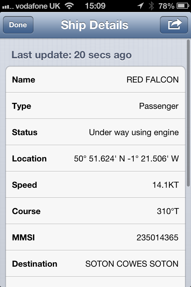
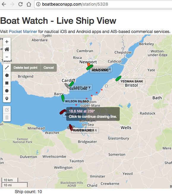
A car container passing just south of me near Portishead (the white flecks on the left are Yachts!)

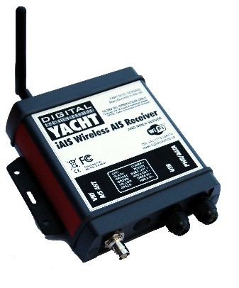
The Ship AIS units cost thousands of dollars. Small AIS receivers are available for around $400 which will allow you to show these boats on a computer screen including their course, speed and  their MMSI – Marine Telephone Number – so you can call them up on VHF radio. But, that requires a large outlay and a computer screen or an even more expensive dedicated unit or Chart Plotter.

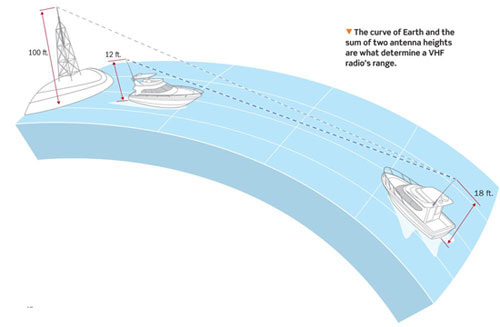
Worse than that there is also the horizon problem. An AIS receiver can only see as far as the horizon. For an aerial mounted at deck height as many are, the horizon is about one nautical mile away  ( http://en.wikipedia.org/wiki/Horizon ). A ship with its AIS aerial at 10m above sea level has a horizon of about six miles. With an approach velocity of 28 knots it could be upon you from nowhere in 15 minutes. This is where the network of shore-based AIS systems come to the fore. As long as you are within GSM coverage and there are AIS shore stations in your area then you can pickup AIS via the Internet and not only see over the horizon but anywhere in the world.

There were already a couple of iPhone apps available which will receive internet AIS data and plot ships’ positions over a Google map. One such app, widely used by sailing fans (though not necessarily sailors themselves) love it for spotting, watching and learning about ships around the world from their desk or the harbour-side cafe. It has even been featured on CNN. I tried using it in the Bristol Channel and it was a decent app, but it’s clearly aimed at landlubbers and there were several key features that, as a Skipper, I needed from an AIS app that this kind of app doesn’t provide. Collision Detection in the background and being able to transmit and share my position on global AIS systems Being the two most important.

I wanted to be alerted if I was on a potential collision course with another boat that I might not even be able to see yet and I didn’t want to have to keep checking a screen every five minutes.

There have been several collisions between small boats and ships reported over the last year. Fortunately no one has been seriously injured in the recent one below in the Solent at Cowes


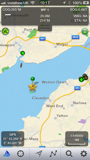
I have been developing apps for mobile devices for over 15 years and decided to put that experience to the task of creating an ideal app for sailors like me – with the result being Boat Beacon. Not only will Boat Beacon display ships and their information on a Google map, it continuously monitors all ships within a 60 mile radius, 5 to 10  times further than a conventional  AIS receiver on my boat could do, and calculates their Closest Point of Approach (CPA).

If any are going to be within 100m of me within the next 10 minutes, Boat Beacon alerts with an alarming Big Ship’s horn – plus a vibration and popup notification. We have tested it out in the Bristol Channel and on a misty day in the Solent and it has proved very reliable and accurate, with no false alarms and no missed alarms.

Boat Beacon compass view on around the Solent

Here is a quote from our test boat skipper in the Solent:

“It was fairly foggy with low vis so app was very useful. All worked well, the alarm was activated in good time and no false alarms as I saw it. Only had three alarms to deal with…………..I can see a new game emerging where one has to induce the collision alarm!”

and another from Lake Erie in the US:

“We did an interesting experiment yesterday while helping a friend bring his 42′ sailboat through the south passage of Lake Erie. On board: Ship Finder Iphone app. a Raymarine AIS driven by E80 MFD and the Boat Beacon. The results within a 40 mi range were: the Ship Finder app had the least number of targets (2) Raymarine AIS had 4 and Boat Beacon had at least 6. Interesting. Additionally the Boat Beacon had more detail on the targets such as Ship names etc. The only rationale for the mid performance of Raymarine AIS could be that some of the targets were on the other side of Kelly’s Island.”

Boat Beacon also has a host of other additional “Sailing” related features that I wanted:

  • Its AIS transmit feature , my wife’s favorite feature, as she can now keep an eye on me and where I am out sailing in the Bristol Channel from a web page on her MacBook at home!
  • A fully gimballed compass and rangefinder overlaid on the map so you can sight ships and shore stations, know their bearing and how far away they are.
  • The ability to highlight other Boat Beacon boats around you so you can keep an eye on the race you are in or the flotilla you are sailing with and a boat to boat  messaging feature so you can chat with them.
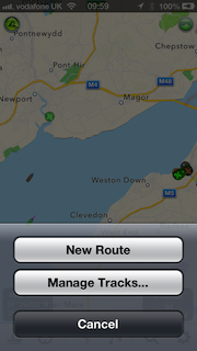
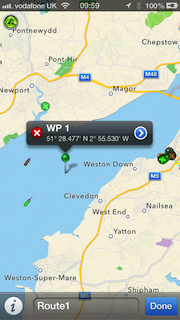
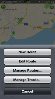
  • Overlay your planned route on the map (Waypoints) and show your track history.
  • Anchor and theft alarm

 Potential Collision detected. Closest Point of Approach – 41 metres in 7.8 mins.

Obviously, Boat Beacon should only be used for basic navigation reference in Coastal areas where there is internet and shore-based station coverage. It should not be solely relied upon to determine precise locations, proximity, distance, or direction. There is no replacement for the Skippers’ and their crews’ eyes and the Skipper’s ultimate judgement.

There are some possible drawbacks with relying on an Internet-based AIS for Coastal Navigation. It relies on you having Internet coverage, however most popular coastal areas in the US have cellular data access extending 12 or more miles out to sea. The UK has nearly complete coastal coverage out to 12 miles. It relies on AIS shore stations covering your area. The network of stations Boat Beacon can access covers the majority of popular coastal and harbour areas. It typically has live data available on over 45,000 ships around the world and coverage is continually increasing. In the unlikely chance that there is no coverage in your area then club together, set up a shore station and join the network!

In some cases, shore-based receivers can be provided for free – see Cover my area for more information. Another reservation is that you won’t show up on the big ships’ AIS systems unless they have an Internet AIS feed too. However, as I mentioned earlier, even if they can see you they are unlikely to be able to do much to avoid you in time!

The tag line for Boat Beacon is “See and be seen on your boat in Coastal Sea areas with 60 mile Collision Avoidance using just your iPhone or Android device. Lets you keep a watch on boats near you and others keep a watch on you using Boat Beacon and Global AIS systems.”