Pocket Mariner’s real time AIS data service, FleetWatch, has been selected by the Pilots at Portsmouth International Port to use with their Portable Pilot Units (PPUs) running SevenCs ORCA Pilot G2solution. The Pilots use Pocket Mariner’s real time enhanced AIS data feed to display live ship positions and courses on and around their client’s ship as they travel out to pilot it. The enhanced feed ensures all the vessel information including name (so you can call the ship via VHF radio) and dimensions is instantly available as soon as the PPU connects unlike VHF AIS where it can take several minutes to acquire the extra data. Ben McInnes, Harbour Master and Portsmouth Pilot said: “The real time internet AIS feed allows us to “virtually board” the ship and assess the situation before we even get there.” Portsmouth have also selected Pocket Mariner’s AIS Replay service to review and playback incidents and for training purposes.
Steve Bennett, Pocket Mariner’s CEO commented: “This is a great endorsement of Pocket Mariner’s “real time” AIS data service that we use to power our own Marine Navigation Apps and we look forward to them using our additional AIS data services including geo-fence event triggering and instant history replay capabilities “.
Please contact us at business@pocketmariner.com to learn more about how our FleetWatch and PortWatch service can help you.
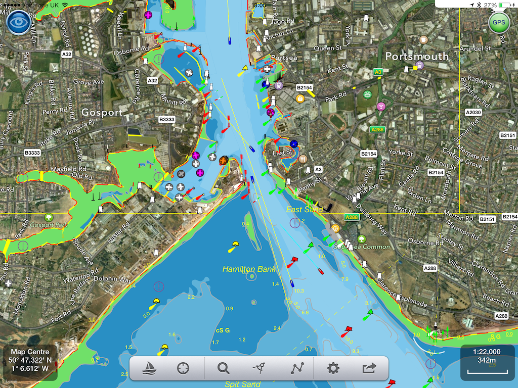
Here is a screenshot of live ship traffic around Portsmouth using the Pocket Mariner AIS service and SeaNav charting app:-
To learn more about Pocket Mariner’s AIS data services, SDK and API’s please email us at business@pocketmariner.com
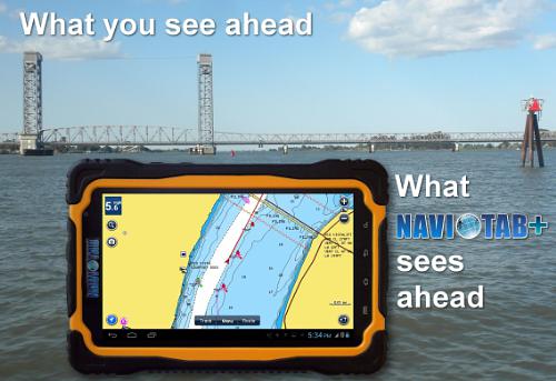
We have been working with IntelliWeather Inc. who have been developing an exciting new marine-rated rugged and waterproof navigation tablet device. The device is now launched and we are delighted they chose to build in our Boat Beacon AIS – Marine Navigation app to provide a fully operational AIS collision avoidance system. Here are some more details on this exciting new device.
A new IP66 rated waterproof and dirtproof Android tablet for marine use provides an all-in-one solution at a fraction of the cost of traditional separate marine electronic devices. It provides navigation, AIS collision avoidance, weather radar, weather bulletins, communications, entertainment, and optional fish finder/sounding capability in one portable device.
The NAVIOTAB+ tablet has been introduced by IntelliWeather Inc., a provider of weather instrumentation, weather display systems, and weather content and comes pre-loaded with ready to run applications and navigation charts for the United States. The user has options to purchase additional navigation charts for most regions of the world provided by Navionics. In addition, in an agreement with PocketMariner of the United Kingdom, the NAVIOTAB+ comes ready to use with a fully operational AIS collision avoidance system. Making use of the built-in GPS and Internet connectivity capabilities to provide a real-time AIS radar like display of vessels near your position in highly trafficked ports and navigable waterways worldwide. This provides an extra level of accuracy and protection allowing you to “see and be seen” with or without MMSI registration.
The NAVIOTAB+ also comes equipped with free weather radar plots and weather bulletins in the USA, including marine weather bulletins. The data is provided free by NOAA and has no subscription requirements. All that is required for live weather radar data and live AIS is an Internet connection via the built-in 3G/4G data capability of the NAVIOTAB+. This can be via a SIM card and most any cellular data carrier that supports a “bring your own” plan for connectivity. Alternately, NAVIOTAB+ can communicate via any 3G/4G capable cellphone that is WiFi hotspot enabled, or any other WiFi Internet connection.
When equipped with a SIM card and cellular data/voice plan, users can initiate and receive telephone calls using the built-in speaker/microphone, earphone, or use a Bluetooth enabled speaker or headset like they would with any cell-phone. Web browsing, email, and MMS messaging are also standard features.
As an entertainment system, NAVIOTAB+ provides a built-in FM radio tuner as well as streaming music services such as Pandora Internet Radio (free) and Sirius XM radio (subscription). Both come installed and can be operated without external antennas. Movies can also be played from streaming services such as YouTube, Netflix, Hulu, and others as well as locally stored files.
Unlike traditional marine electronics, the NAVIOTAB+ is not married to your boat, it can be taken “on the go” anywhere as a regular tablet and can also serve as an automobile navigation system via the built-in Google Maps application.
To round out the features, with the addition of a DEEPER Bluetooth enabled transducer, fish finding, water temperature, and depth sounding capability can be added to the NAVIOTAB+.
A powerful 10,000 mAH Lithium-Ion battery provides operation which can exceed 8 hours. The tablet can also be continuously charged/powered directly from your boat via the included Blue Sea Systems marine rated 12 volt cigarette lighter to USB power adapter and the included USB power cable.
Sporting a Quad-core 1.2 GHz A9 processor, 1 GB of RAM, and 8GB of FLASH storage, the NAVIOTAB+ is fast and responsive. Storage can be expanded up to an additional 32GB with insertion of a micro SD storage card. The bright 7″ screen is protected by toughened scratch resistant glass and can be seen in daylight, plus offers automatic dimming for night use. The built-in GPS receiver system does not require an external antenna, and is accurate to within 3 meters (10 feet).
Weighing just 1.36 pounds, NAVIOTAB+ is easily portable, and easy to secure to windshields, dashboards, and rails with a wide variety of readily available tablet mounting systems. It also comes with a palm rest/strap to enable portable use.
Tally up and compare the cost of all the separate marine rated devices that are replaced by the NAVIOTAB+ and you’ll understand why it makes the most sense for the recreational boater that doesn’t want to spend a fortune on getting their boat equipped. For the professional mariner, NAVIOTAB+ also makes a great backup system for your bridge, or as an emergency navigation system.
The NAVIOTAB+ has a manufacturer’s suggested retail price of $649.00.
Dealer inquiries are invited.
For further information these resources are available.
Navionics have launched a new version (7.0) of their Navionics Boating app which now includes free US NOAA vector charts. If you are boating in the US you can now get a well respected and functional marine navigation app on your iPad and iPhone without spending a cent. What are they up to? Why should you go anywhere else? How can they give away a full blown marine navigation app for free? We hope the following comparison and charts around San Francisco can help you decide which route to follow.
Here is the view of San Francisco from SeaNav within a 3 mile radius – the horizon for most leisure boat users (6NM x 6NM square) :-
and the same scale on Navionics Boating with their free NOAA charts :-
What?
We zoomed in and eventually (at three times the scale) details appeared:-
Compare this with SeaNav at the same scale:-
We hope you will agree that its a lot less cluttered, has more relevant information and is a lot easier to view. Zoom in and more details and spot depths will be shown. You can also choose what level of detail to show in SeaNav.
Other key differences:-
SeaNav includes full live navigation features including COG, SOG, HDG, ETA, Waypoint distance and time, Cross Track error, Course and North up view etc. – it’s at least a $5 extra for Navionics and that doesn’t get you much of what SeaNav offers.
SeaNav includes Tides – Navionics Boating free doesn’t – you have to buy their USA chart set at $70.
SeaNav has a unique and highly recommended AR Camera view showing buoys, ships, landmarks etc. overlaid on the real time camera view.
SeaNav has live AIS Ship data overlay including collision detection. (via Boat Beacon).
SeaNav – buy once and runs at full HD on both your iPad and iPhone with no need to purchase another version.
SeaNav including full charts is just $19.99 in the US and £14.99 in the UK. See how this unfortunate user ended up paying over £70 ($100) for Navionics “Free”:-
Boat Beacon now allows you to use AIS and GPS NMEA data directly from an AIS receiver and GPS on-board your boat via WiFi (over UDP or TCP) or Serial(USB). Boat Beacon seamlessly combines this with the AIS information it receives over the internet. If you travel outside mobile internet coverage or in an area where we don’t have good coverage from a local shore station, Boat Beacon can now continue to work displaying live ship data, calculating Closest Point of Approach (CPA) with alarms etc. from your VHF AIS receiver or AIS enabled VHF radio. On Android you can connect the NMEA serial or usb output from an AIS receiver or connect via WiFi. On iPhone you need to use WiFi. Here are some of the AIS receivers we have tested with Lowrance, Simrad, B&G, Digital Yacht, Comar NMEA-w2-Wifi, Weatherdock EasyAIS, Chetco Digital SeaSmart , dAISy AIS, Navico GoFree, Quark AIS (dual channel and usb stick) etc. More information on how to hook all this up is given below.
iPhone and Android AIS and GPS over WiFi.
If you already have AIS data available over Wifi on board then just enter the UDP port number (or ip address and port number for TCP) for the source and Boat Beacon will start using the data. With Navico GoFree and iPhone/iPad this is even more simple as there is a “GoFree” connect button in settings – just press and go. If you only have a usb or nmea output available you will also need a serial or usb to internet or Wifi adaptor. They range in price from $50 to $200. This is one example we have tested with at the $70 level – USR-TCP232-400 that we hook into our on-board WiFi hub.
Boat Beacon will automatically launch and use local AIS data (and GPS if available) when a USB cable is plugged in between the AIS receiver and your Android device. You can set the USB mode on or off in settings in Boat Beacon.
For an Android NMEA 0183 connection you will need the following:-
1. An Android device that supports USB host mode (typically OS3 or later)
2. If your receiver doesn’t have a USB output you can simply convert the NMEA 0183 2 wire output to USB for a few dollars more using an RS232 to USB cable. Typically $7 or so. The most common USB to RS232 cables use the Prolific 2303 driver which we support. The cable we tested with is this one :-
We also support many other serial usb drivers (see below).
3. You will also need an Android OTG micro usb adaptor which only cost a couple of dollars. Here are a couple of links to the type of OTG micro usb adapter you will need:-
You can get Boat Beacon from the iTunes or Android stores – Boat Beacon
If you have a problem connecting with Android over usb you can run this free simple serial usb tester program on your Android device once you have an OTG adaptorto report and test what driver is required and let us know :-
Our unique AR view mode allows you to view buoys, lights, ships, waypoints and track overlaid on your iPhone or iPad live camera view. With “AR LockOn” you can select a target on the chart and then be guided to it in the AR camera view.
Find that ship on the horizon and instantly see its name, range and bearing.
Spot the next marker buoy.
See your route and next waypoint
Tap the “eye” icon at the top left to switch AR mode on, then tilt your device up to see a live camera of the scene and boats around you. As you turn round and view buoys and ships, their name, range and bearing will popup when they are in the center of the view. You can also tap on them to get more information. Tilt back down to see the map view. Tapping the “eye” icon again turns AR mode off. You can pinch to zoom the map or camera views.
In AR mode our unique “AR Lock On” feature lets you select a ship or buoy on the map view and then easily locate it in the Camera view using a grey arrow to tell you which way to turn to spot it when its not directly in view. Your course (yellow line) and route to next waypoint (blue line) will also be visible overlayed on the camera view.
Ships are color coded based on their type e.g. Sailing boats are white, Pleasure Craft magenta, etc. See the Map Legend for full details. A vector points forward showing where each boat will be in 2 minutes time based on its current Speed and Course. Ships move in real time across the map and in the AR view. Tap on a ship or buoy to get more information and tap on the right arrow to get even more including speed, course, distance, bearing, picture etc. The horizon is set by the zoom scale of the chart view – e.g. zoom out on the chart view to see further out in the Augmented reality view.
Our network of AIS coverage around the world is amongst the best in the industry. However we are always looking to add new areas and improve existing ones.
Thanks to John Ambler on the Isle of Wight sharing his AIS data directly to our servers our users now have greatly improved real time coverage around the Solent and English Channel.
Here’s a screenshot showing the range of ships his receiver is picking up from an aerial 200 feet above sea level on the island.
Coverage around the Isle of Wight
You can check the live coverage on John’s web page and in real time on Boat Beacon and SeaNav too.
Another sea trial today. Out of Portishead Harbour up channel to the Second Servern Crossing and back on the turn of the tide.
No “sinkings or drownings” though a lot of diesel fumes and some litres lost due to the fuel tank filler nozzle fracturing off in the “moderate to severe” seas in force 5/6 – spray right over the top of the boat and front of the boat completely under water at times! A bit of a baptism of fire for my young son, but he coped admirably.
We had 3 serious close encounters with a large dredger off Avonmouth that Boat Beacon really helped with. First off, Boat Beacon started flashing that the dredger was on a collision course with us even though visually it looked like it was sideways on passing behind us. The currents are deceptive. We could find out the name of the ship immediately from Boat Beacon, UKD BLUEFIN, and thus radio it to ask what its intentions were. Unfortunately no reply on VHF channel 16. Then we heard another Boat call up the Bristol port authority (VTS) on channel 12 about the ship to ask what it was doing. If we hadn’t known the ship’s name we would not have appreciated the value of the subsequent radio dialogue. It was dredging just outside the port and would turn round to go back in to port to continue its dredging. So although we thought it was headed straight for us – it turned and went back and we carried on.
An hour later on our return down estuary to Portishead the ‘Death Star dredger’ BLUEFIN came out of Avonmouth yet again headed straight for us on our port side. We were hoping/thinking it might just turn around again to head back in to continue dredging. We radio’d the Port Authority to ask what its intentions were. No. This time it had finished dredging for the day and was really heading for us on its way to drop its load on the spoil ground off Portishead. So we made a speed and course change to pass behind it.
Home stretch. Sea state moderate , waves still breaking over the canopy, dredger on the horizon, sideways on to us and stationary on Boat Beacon, only 2NM to go to Portishead Marina. Time for a cup of tea. Alarm. Dreaded Dredger heading straight for us again! It had completed dumping and was returning to Avonmouth – at 10 Kts and 1 NM off. Time for a 90 degree course change. The challenge was whether to head out to sea towards Wales to pass port to port (accepted behaviour) or head in towards shallow water where the dredger should not go. Heading out risked missing Portishead altogether – we couldn’t beat the tide that was now running at 3 Kts- and might have to spend another 3 hours of heavy wind over tide waves to Cardiff. Boat Beacon gave me the confidence that we could make the dash for shallow water – which we did………(see red arrow on screen shot below)
The long straight white dotted track line leading North is the bug we discovered in the first day of Sea trials – fixed for the next release of SeaNav.
We took Sarita, my 27′ catamaran out to test the latest versions of SeaNav and Boat Beacon at sea in the Bristol Channel. The planned route was a 6 hour passage on the ebb tide from Chepstow to Cardiff (see SeaNav route plan below). 3 persons on board; Captain Keith Avery of the RSS Discovery ( see the excerpt from Sarah Casey’s book – the Wave ) , our Vicar, also an ex-merchant navy officer and myself. Illustrious company.
The trip went well and to plan until we were just off Portishead where strong wind against tide made the going very uncomfortable and slow. As we didn’t have to get to Cardiff that day we decided to stop over in Portishead. Boat Beacon transmitted our position faithfully and my family tracked our progress live on our Boat Watch app and the web ( http://boatbeaconapp.com/go/MMSI ). Captain Avery helmed most of the way and was impressed with our apps. Check the screenshots below for the route, track and web views. The blue line and pins are the planned route and waypoints, the white dotted line is the recorded track. You can see the exact pontoon we tied Sarita up at in Portishead Dock!
57.5° N, 12.7° W 175 MILES OFF THE COAST OF SCOTLAND FEBRUARY 8, 2000
The clock read midnight when the hundred-foot wave hit the ship, rising from the North Atlantic out of the darkness. Among the ocean’s terrors a wave this size was the most feared and the least understood, more myth than reality—or so people had thought. This giant was certainly real. As the RRS Discovery plunged down into the wave’s deep trough, it heeled twenty- eight degrees to port, rolled thirty degrees back to starboard, then recovered to face the incoming seas. What chance did they have, the forty-seven scientists and crew aboard this research cruise gone horribly wrong? A series of storms had trapped them in the black void east of Rockall, a volcanic island nicknamed Waveland for the nastiness of its surrounding waters. More than a thousand wrecked ships lay on the seafloor below.
Captain Keith Avery steered his vessel directly into the onslaught, just as he’d been doing for the past five days. While weather like this was common in the cranky North Atlantic, these giant waves were unlike anything he’d encountered in his thirty years of experience. And worse, they kept rearing up from different directions. Flanking all sides of the 295-foot ship, the crew kept a constant watch to make sure they weren’t about to be sucker punched by a wave that was sneaking up from behind, or from the sides. No one wanted to be out here right now, but Avery knew their only hope was to remain where they were, with their bow pointed into the waves. Turning around was too risky; if one of these waves caught Discovery broadside, there would be long odds on survival. It takes thirty tons per square meter of force to dent a ship. A breaking hundred-foot wave packs one hundred tons of force per square meter and can tear a ship in half. Above all, Avery had to position Discovery so that it rode over these crests and wasn’t crushed beneath them.
He stood barefoot at the helm, the only way he could maintain traction after a refrigerator toppled over, splashing out a slick of milk, juice, and broken glass (no time to clean it up—the waves just kept coming). Up on the bridge everything was amplified, all the night noises and motions, the slamming and the crashing, the elevator-shaft plunges into the troughs, the frantic wind, the swaying and groaning of the ship; and now, as the waves suddenly grew even bigger and meaner and steeper, Avery heard a loud bang coming from Discovery’s foredeck. He squinted in the dark to see that the fifty-man lifeboat had partially ripped from its two-inch-thick steel cleats and was pounding against the hull.Below deck, computers and furniture had been smashed into pieces. The scientists huddled in their cabins nursing bruises, black eyes, and broken ribs. Attempts at rest were pointless. They heard the noises too; they rode the free falls and the sickening barrel rolls; and they worried about the fact that a six-foot-long window next to their lab had already shattered from the twisting. Discovery was almost forty years old, and recently she’d undergone major surgery. The ship had been cut in half, lengthened by thirty-three feet, and then welded back together. Would the joints hold? No one really knew. No one had ever been in conditions like these.One of the two chief scientists, Penny Holliday, watched as a chair skidded out from under her desk, swung into the air, and crashed onto her bunk. Holliday, fine boned, porcelain-doll pretty, and as tough as any man on board the ship, had sent an e- mail to her boyfriend, Craig Harris, earlier in the day. “This isn’t funny anymore,” she wrote. “The ocean justlooks completely out of control.” So much white spray was whipping off the waves that she had the strange impression of being in a blizzard. This was Waveland all right, an otherworldly place of constant motion that took you nowhere but up and down; where there was no sleep, no comfort, no connection to land, and where human eyes and stomachs struggled to adapt, and failed.Ten days ago Discovery had left port in Southampton, England, on what Holliday had hoped would be a typical three-week trip to Iceland and back (punctuated by a little seasickness perhaps, but nothing major). Along the way they’d stop and sample the water for salinity, temperature, oxygen, and other nutrients. From these tests the scientists would draw a picture of what was happening out there, how the ocean’s basic characteristics were shifting, and why.
These are not small questions on a planet that is 71 percent covered in salt water. As the Earth’s climate changes—as the inner atmosphere becomes warmer, as the winds increase, as the oceans heat up—what does all this mean for us? Trouble, most likely, and Holliday and her colleagues were in the business of finding out how much and what kind. It was deeply frustrating for them to be lashed to their bunks rather than out on the deck lowering their instruments. No one was thinking about Iceland anymore.The trip was far from a loss, however. During the endless trains of massive waves, Discovery itself was collecting data that would lead to a chilling revelation. The ship was ringed with instruments; everything that happened out there was being precisely measured, the sea’s fury captured in tight graphs and unassailable numbers. Months later, long after Avery had returned everyone safely to the Southampton docks, when Holliday began to analyze these figures, she would discover that the waves they had experienced were the largest ever scientifically recorded in the open ocean. The significant wave height, an average of the largest 33 percent of the waves, was sixty-one feet, with frequent spikes far beyond that. At the same time, none of the state-of-the-art weather forecasts and wave models—the information upon which all ships, oil rigs, fisheries, and passenger boats rely—had predicted these behemoths. In other words, under this particular set of weather conditions, waves this size should not have existed. And yet they did.
We have now launched our new Boat Beacon companion app, Boat Watch.
Boat Watch is a free app, which offers…
* Spot any Boat or Ship via real-time AIS
* See the Name, Type and Destination of each vessel
* Set any boat as your favoirite, and automatically track it on the map
* Search and find boats and places
* Share boats on Facebook, Twitter or by email
Optional One-time In-App Upgrade Purchase adds…
* Get alerts when your favourite boat arrives or departs
* Full boat information – speed, course, country, etc.
For Boat Beacon users, Boat Watch is a great app to tell your friends and family about so they can follow your voyage.
Boat Watch is a Universal app, which works on iPhone, iPod and iPad.
As part of the Boat Watch launch we are sponsoring the Ahoy Centre Totally Oarsome! charity – which challenges you to test your abilities, get fit and raise money for the Ahoy charity to help others.
Let your family , friends and supporters follow you in real time on their iPhone, iPad or iPod as you take on AHOY’s ultimate rowing challenge.
Pocket Mariner are sponsoring the Ahoy Centre by providing every rowing team with a free copy of their Boat Beacon AIS tracking app. All you need to do is enter your team name in the boat details, then invite your family, friends and supporters to follow you in the FREE Boat Watch app. Tap the Sail button in Boat Beacon to start tracking. Boat watchers will be able to see your position and track updated continuously as well as all the other boats around you. See the screen-shots above for an idea of what you can see on the Boat Watch app.
With the Boat Watch In-App purchase option for only £1.99, family, friends and supporters are able to monitor your speed, course, destination and ETA details. They also get automatic alerts on their iPhone, iPad or iPod when you start and finish or stop midway!
All proceeds from the In-App purchases during the challenge will go to the AHOY Centre.
We had some great feedback from one of our users, Ken, in Southern California:-
I have now been using Boat Beacon in the southern California waters for the past few months and really enjoy the visibility it provides me. Just this past weekend, my Yacht Club had a large cruise over the 4th in Catalina and in my trip over, I had a cargo ship that, based on Boat Beacon CPA data, going to get really close. I called the ship, by name, on VHF Channel 16 and based on the conversation, he changed course, which again we had a conversation with him telling me what he had planned to do etc.
It is exactly that type of data that made my trip along with a lot of others.
My question is; I have an assigned MMSI and Transmitting from the iPad, I “see” the ships, do they “see” me on their shipboard system? I know I can be seen on ship finder, Marine Traffic, but not sure if they see me in real time on their system.
BTW; a number of my club members who were in transit had heard my call and discussion and came away impressed with what Boat Beacon can do. A number of them have already downloaded it onto their apple IOS and Android devices.
In answer to Ken’s question, if you are only transmitting your position using Boat Beacon then the ships will not be able to see you on their VHF AIS Systems. However many of the Coast Guard stations and Harbour/Port Authorities around the US, UK and Australia do now combine internet AIS feeds with their local VHF AIS data, so there is a good chance you will be showing up on their screens.


")


