Another sea trial today. Out of Portishead Harbour up channel to the Second Servern Crossing and back on the turn of the tide.
No “sinkings or drownings” though a lot of diesel fumes and some litres lost due to the fuel tank filler nozzle fracturing off in the “moderate to severe” seas in force 5/6 – spray right over the top of the boat and front of the boat completely under water at times! A bit of a baptism of fire for my young son, but he coped admirably.
We had 3 serious close encounters with a large dredger off Avonmouth that Boat Beacon really helped with. First off, Boat Beacon started flashing that the dredger was on a collision course with us even though visually it looked like it was sideways on passing behind us. The currents are deceptive. We could find out the name of the ship immediately from Boat Beacon, UKD BLUEFIN, and thus radio it to ask what its intentions were. Unfortunately no reply on VHF channel 16. Then we heard another Boat call up the Bristol port authority (VTS) on channel 12 about the ship to ask what it was doing. If we hadn’t known the ship’s name we would not have appreciated the value of the subsequent radio dialogue. It was dredging just outside the port and would turn round to go back in to port to continue its dredging. So although we thought it was headed straight for us – it turned and went back and we carried on.
An hour later on our return down estuary to Portishead the ‘Death Star dredger’ BLUEFIN came out of Avonmouth yet again headed straight for us on our port side. We were hoping/thinking it might just turn around again to head back in to continue dredging. We radio’d the Port Authority to ask what its intentions were. No. This time it had finished dredging for the day and was really heading for us on its way to drop its load on the spoil ground off Portishead. So we made a speed and course change to pass behind it.
Home stretch. Sea state moderate , waves still breaking over the canopy, dredger on the horizon, sideways on to us and stationary on Boat Beacon, only 2NM to go to Portishead Marina. Time for a cup of tea. Alarm. Dreaded Dredger heading straight for us again! It had completed dumping and was returning to Avonmouth – at 10 Kts and 1 NM off. Time for a 90 degree course change. The challenge was whether to head out to sea towards Wales to pass port to port (accepted behaviour) or head in towards shallow water where the dredger should not go. Heading out risked missing Portishead altogether – we couldn’t beat the tide that was now running at 3 Kts- and might have to spend another 3 hours of heavy wind over tide waves to Cardiff. Boat Beacon gave me the confidence that we could make the dash for shallow water – which we did………(see red arrow on screen shot below)
The long straight white dotted track line leading North is the bug we discovered in the first day of Sea trials – fixed for the next release of SeaNav.
We took Sarita, my 27′ catamaran out to test the latest versions of SeaNav and Boat Beacon at sea in the Bristol Channel. The planned route was a 6 hour passage on the ebb tide from Chepstow to Cardiff (see SeaNav route plan below). 3 persons on board; Captain Keith Avery of the RSS Discovery ( see the excerpt from Sarah Casey’s book – the Wave ) , our Vicar, also an ex-merchant navy officer and myself. Illustrious company.
The trip went well and to plan until we were just off Portishead where strong wind against tide made the going very uncomfortable and slow. As we didn’t have to get to Cardiff that day we decided to stop over in Portishead. Boat Beacon transmitted our position faithfully and my family tracked our progress live on our Boat Watch app and the web ( http://boatbeaconapp.com/go/MMSI ). Captain Avery helmed most of the way and was impressed with our apps. Check the screenshots below for the route, track and web views. The blue line and pins are the planned route and waypoints, the white dotted line is the recorded track. You can see the exact pontoon we tied Sarita up at in Portishead Dock!
57.5° N, 12.7° W 175 MILES OFF THE COAST OF SCOTLAND FEBRUARY 8, 2000
The clock read midnight when the hundred-foot wave hit the ship, rising from the North Atlantic out of the darkness. Among the ocean’s terrors a wave this size was the most feared and the least understood, more myth than reality—or so people had thought. This giant was certainly real. As the RRS Discovery plunged down into the wave’s deep trough, it heeled twenty- eight degrees to port, rolled thirty degrees back to starboard, then recovered to face the incoming seas. What chance did they have, the forty-seven scientists and crew aboard this research cruise gone horribly wrong? A series of storms had trapped them in the black void east of Rockall, a volcanic island nicknamed Waveland for the nastiness of its surrounding waters. More than a thousand wrecked ships lay on the seafloor below.
Captain Keith Avery steered his vessel directly into the onslaught, just as he’d been doing for the past five days. While weather like this was common in the cranky North Atlantic, these giant waves were unlike anything he’d encountered in his thirty years of experience. And worse, they kept rearing up from different directions. Flanking all sides of the 295-foot ship, the crew kept a constant watch to make sure they weren’t about to be sucker punched by a wave that was sneaking up from behind, or from the sides. No one wanted to be out here right now, but Avery knew their only hope was to remain where they were, with their bow pointed into the waves. Turning around was too risky; if one of these waves caught Discovery broadside, there would be long odds on survival. It takes thirty tons per square meter of force to dent a ship. A breaking hundred-foot wave packs one hundred tons of force per square meter and can tear a ship in half. Above all, Avery had to position Discovery so that it rode over these crests and wasn’t crushed beneath them.
He stood barefoot at the helm, the only way he could maintain traction after a refrigerator toppled over, splashing out a slick of milk, juice, and broken glass (no time to clean it up—the waves just kept coming). Up on the bridge everything was amplified, all the night noises and motions, the slamming and the crashing, the elevator-shaft plunges into the troughs, the frantic wind, the swaying and groaning of the ship; and now, as the waves suddenly grew even bigger and meaner and steeper, Avery heard a loud bang coming from Discovery’s foredeck. He squinted in the dark to see that the fifty-man lifeboat had partially ripped from its two-inch-thick steel cleats and was pounding against the hull.Below deck, computers and furniture had been smashed into pieces. The scientists huddled in their cabins nursing bruises, black eyes, and broken ribs. Attempts at rest were pointless. They heard the noises too; they rode the free falls and the sickening barrel rolls; and they worried about the fact that a six-foot-long window next to their lab had already shattered from the twisting. Discovery was almost forty years old, and recently she’d undergone major surgery. The ship had been cut in half, lengthened by thirty-three feet, and then welded back together. Would the joints hold? No one really knew. No one had ever been in conditions like these.One of the two chief scientists, Penny Holliday, watched as a chair skidded out from under her desk, swung into the air, and crashed onto her bunk. Holliday, fine boned, porcelain-doll pretty, and as tough as any man on board the ship, had sent an e- mail to her boyfriend, Craig Harris, earlier in the day. “This isn’t funny anymore,” she wrote. “The ocean justlooks completely out of control.” So much white spray was whipping off the waves that she had the strange impression of being in a blizzard. This was Waveland all right, an otherworldly place of constant motion that took you nowhere but up and down; where there was no sleep, no comfort, no connection to land, and where human eyes and stomachs struggled to adapt, and failed.Ten days ago Discovery had left port in Southampton, England, on what Holliday had hoped would be a typical three-week trip to Iceland and back (punctuated by a little seasickness perhaps, but nothing major). Along the way they’d stop and sample the water for salinity, temperature, oxygen, and other nutrients. From these tests the scientists would draw a picture of what was happening out there, how the ocean’s basic characteristics were shifting, and why.
These are not small questions on a planet that is 71 percent covered in salt water. As the Earth’s climate changes—as the inner atmosphere becomes warmer, as the winds increase, as the oceans heat up—what does all this mean for us? Trouble, most likely, and Holliday and her colleagues were in the business of finding out how much and what kind. It was deeply frustrating for them to be lashed to their bunks rather than out on the deck lowering their instruments. No one was thinking about Iceland anymore.The trip was far from a loss, however. During the endless trains of massive waves, Discovery itself was collecting data that would lead to a chilling revelation. The ship was ringed with instruments; everything that happened out there was being precisely measured, the sea’s fury captured in tight graphs and unassailable numbers. Months later, long after Avery had returned everyone safely to the Southampton docks, when Holliday began to analyze these figures, she would discover that the waves they had experienced were the largest ever scientifically recorded in the open ocean. The significant wave height, an average of the largest 33 percent of the waves, was sixty-one feet, with frequent spikes far beyond that. At the same time, none of the state-of-the-art weather forecasts and wave models—the information upon which all ships, oil rigs, fisheries, and passenger boats rely—had predicted these behemoths. In other words, under this particular set of weather conditions, waves this size should not have existed. And yet they did.
We have now launched our new Boat Beacon companion app, Boat Watch.
Boat Watch is a free app, which offers…
* Spot any Boat or Ship via real-time AIS
* See the Name, Type and Destination of each vessel
* Set any boat as your favoirite, and automatically track it on the map
* Search and find boats and places
* Share boats on Facebook, Twitter or by email
Optional One-time In-App Upgrade Purchase adds…
* Get alerts when your favourite boat arrives or departs
* Full boat information – speed, course, country, etc.
For Boat Beacon users, Boat Watch is a great app to tell your friends and family about so they can follow your voyage.
Boat Watch is a Universal app, which works on iPhone, iPod and iPad.
As part of the Boat Watch launch we are sponsoring the Ahoy Centre Totally Oarsome! charity – which challenges you to test your abilities, get fit and raise money for the Ahoy charity to help others.
Let your family , friends and supporters follow you in real time on their iPhone, iPad or iPod as you take on AHOY’s ultimate rowing challenge.
Pocket Mariner are sponsoring the Ahoy Centre by providing every rowing team with a free copy of their Boat Beacon AIS tracking app. All you need to do is enter your team name in the boat details, then invite your family, friends and supporters to follow you in the FREE Boat Watch app. Tap the Sail button in Boat Beacon to start tracking. Boat watchers will be able to see your position and track updated continuously as well as all the other boats around you. See the screen-shots above for an idea of what you can see on the Boat Watch app.
With the Boat Watch In-App purchase option for only £1.99, family, friends and supporters are able to monitor your speed, course, destination and ETA details. They also get automatic alerts on their iPhone, iPad or iPod when you start and finish or stop midway!
All proceeds from the In-App purchases during the challenge will go to the AHOY Centre.
We had some great feedback from one of our users, Ken, in Southern California:-
I have now been using Boat Beacon in the southern California waters for the past few months and really enjoy the visibility it provides me. Just this past weekend, my Yacht Club had a large cruise over the 4th in Catalina and in my trip over, I had a cargo ship that, based on Boat Beacon CPA data, going to get really close. I called the ship, by name, on VHF Channel 16 and based on the conversation, he changed course, which again we had a conversation with him telling me what he had planned to do etc.
It is exactly that type of data that made my trip along with a lot of others.
My question is; I have an assigned MMSI and Transmitting from the iPad, I “see” the ships, do they “see” me on their shipboard system? I know I can be seen on ship finder, Marine Traffic, but not sure if they see me in real time on their system.
BTW; a number of my club members who were in transit had heard my call and discussion and came away impressed with what Boat Beacon can do. A number of them have already downloaded it onto their apple IOS and Android devices.
In answer to Ken’s question, if you are only transmitting your position using Boat Beacon then the ships will not be able to see you on their VHF AIS Systems. However many of the Coast Guard stations and Harbour/Port Authorities around the US, UK and Australia do now combine internet AIS feeds with their local VHF AIS data, so there is a good chance you will be showing up on their screens.
Wales, UK – Pocket Mariner’s recently launched SeaNav app, with versions for both the US and UK/Ireland, has been updated to offer a more complete charting and navigation toolkit for boaters. To improve navigation and collision avoidance when out of reach of cell phone coverage, SeaNav — together with Pocket Mariner’s Boat Beacon app — can now also use on-board live VHF AIS data feeds. The app also now enables sailors to jump directly to specific locations using latitude and longitude searches and has been extended for use on iPods as well as iPhone and iPad.
SeaNav was designed to enable boaters to explore, plan and navigate their boating trips in real-time and high-resolution using the latest up to date Digital Vector Marine charts covering the US coastlines and Great Lakes or the UK and Ireland. Pocket Mariner has successfully completed sea trials of the new local AIS feature with Lowrance, Simrad and B&G’s GoFree™ wireless systems, as well as with easyAIS and Digital Yacht.
Robert Langford-Wood Product Manager for GoFree Technology said: “Applications such as SeaNav and Boat Beacon, when combined with GoFree wireless, allow boaters to make the most out of their Lowrance, Simrad and B&G chartplotters and AIS systems away from the helm. It means that every member of the crew can have a navigator’s eye view, increasing safety and enjoyment out on the water – a great innovation!”
SeaNav works best when paired with Pocket Mariner’s Boat Beacon, which has become an enormously popular app among sailors for its simple-to-use location sharing and real-time “Map View” of both the user’s and other nearby boats via AIS. Together, SeaNav and Boat Beacon provide a powerful set of charting, navigation and location-sharing tools. While Boat Beacon provides SeaNav with its AIS data and alarms, Boat Beacon gets marine charts and routes from SeaNav. The two apps share hot-jump buttons that ensure they are both on the same location and at the same zoom level on the map.
Key features of SeaNav include:
• Route Planning and real time tracking including Waypoints, SOG, COG, ETA, CTE etc.
• Route and Track export, import and sharing.
• Charts downloaded and stored on device so they work without mobile coverage!
• Seamless fast panning and zooming across charts.
• Live AIS Ship positions overlaid from Pocket Mariner’s Boat Beacon app.
• Configurable layers; buoys, lights, depths, rocks, wrecks, anchorage areas etc.
• Automatic Chart updates.
SeaNav has two versions, SeaNav US which uses NOAA charts providing complete coverage of USA and Great Lakes and free chart updates for life. SeaNav UK uses UKHO Admiralty charts and includes the complete set of charts for the UK and Ireland plus a year of free chart updates in the one-off price. New versions of the app with charts for other countries and regions are in the works.
Both versions are available from the App Store for iPhone, iPad, and – in this latest version – on an iPod touch, for US$9.99 and £9.99 in the UK.
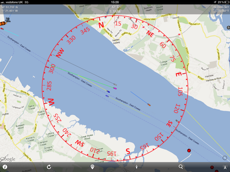
Live screenshots testing Boat Beacon in the Solent
Our test boat!
Live view from Boat Beacon: the test boat is the purple boat in the centre, while the Ferry is blue to port
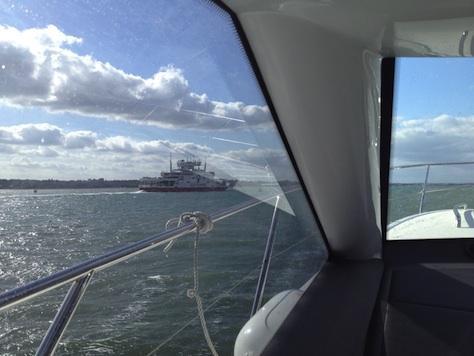
View of the blue target (Ferry) from bridge of our boat.
About Navico: Navico is currently the world’s largest marine electronics company, and is producing products under leading marine electronics brands: Lowrance, Simrad and B&G. Navico has approximately 1,500 employees globally and distribution in more than 100 countries worldwide. www.navico.com
We were asked if we could help out with a new Australian Coast Guard radio log system using Boat Beacon. The system is now live and made it onto Australian TV.
Captain Ian Engelbrecht and First Mate Ibolya Palko from Worldwide Yacht Deliveries sent us a report today on how Boat Beacon helped them when they were caught in fog 4NM off the South African coast. They were sailing a Jaguar 36 Catamaran on a 900 mile, 12 day voyage from Cape Town to Durban, South Africa. There is a map showing their planned route to the right. They had just passed Hamburg on their route up the East South African coast when they lost visibility. Their primary AIS system had failed. They did the right thing and diverted in close to shore to find shallow waters and avoid any commercial shipping (see the track map below). They were hoping there wouldn’t be anything else so close in. They decided to power up Boat Beacon on their Android smartphone and leave it running to keep a look out.
Boat Beacon alerted them to a container ship, also close in, going in the opposite direction! At a range of 21 NM ( well over the normal VHF AIS horizon) Boat Beacon gave them plenty of time to assess the situation and take the necessary avoiding action.
They also had some very useful feedback. Having no visibility and due to the specific courses involved, they weren’t too sure on how the Closest Point of Approach (CPA) would pan out. In other words what would the CPA be in relation to their vessel – port or starboard? That made it difficult to decide on the correct avoiding action to take. Captain Iain Engelbrecht asked if we could add a new feature to Boat Beacon to give the bearing of the closest point of approach with respect to one’s own boat (e.g. 0° is dead ahead, 90° to starboard, 270° is to port etc.).
Captain Engelbrecht was impressed by Boat Beacon’s real time performance – that may have saved their lives – and our immediate response to his suggestion. We are now adding the new CPA Bearing feature, continuing Pocket Mariner’s commitment to providing useful, professional and affordable aids to navigation and safety.
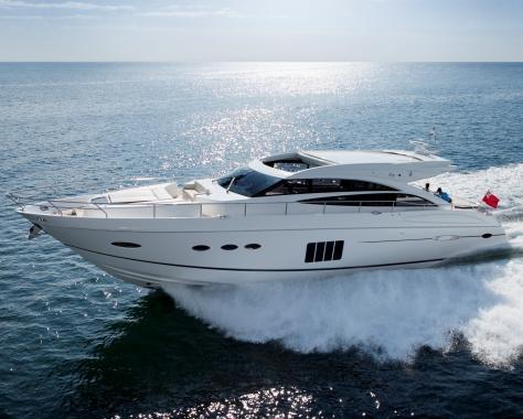
We popped down to the Southampton Boat Show to share our wares and look for new App ideas. We also got a chance to take Boat Beacon out for a spin on a $1M Speed boat and test at high speed!
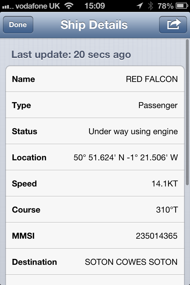
Here are some real time screen shots from the boat and of Boat Beacon’s display. All lined up in real time perfectly. We are on the purple boat in the centre of the screenshot doing just over 20Kts overtaking Red Falcon which is to port.
We chatted with McMurdo about their new and very popular S10 and Kannad R10 PersonalAIS Beacons (see Panbo’s article) – flying off the shelves like hot cakes. They appear on Boat Beacon when activated and in test mode, but were showing up as unknown ships! Time to add some proper support. Show them with the correct AIS SART symbol (red cross) , show the Safety message sent by the device and alarm if one appears within range. The typical range quoted for these beacons at sea level is 4 miles. With Boat Beacon using shore based receivers we should be able to see them further away at upto 10 miles out! Any volunteers for testing?
The latest Android version (1.2) of Boat Beacon now has AIS SART support and it will be included in the next iOS release.
We met up with Yachting Monthly Editor, Keiran Flatt and he is going to publish our Marine Apps survey on-line and in the next print edition and he also had some ideas for new Marine Apps he would like to see. He is thinking of setting up a photo shoot and story about our company with a trip down the Wye to the Severn from our offices on Sarita.
A fantastic day and some great new ideas and opportunites for Boat Beacon and for some new Apps.

")