Zeus, Simrad and B&G GoFree settings for Boat Beacon

Here are some instructions on how to connect to GoFree on Boat Beacon Android to use AIS from your own boat’s AIS receiver.

On the B&G: Settings Page –> network –> nmea0183  –> Ethernet , take note of the IP Address (e.g. 192.168.1.109)  and Port  (port is usually 10110) . See screenshot below


 Inline images 1

In Boat Beacon: go to Settings –> scroll down to AIS Sources. Tap Local AIS and select TCP. Then tap Local AIS host and enter the IP address you noted from your B&G device. Then tap Local AIS port and enter the port number – e.g. 10110. Boat Beacon should then see the AIS data from your B&G instrument and the Local AIS light on Boat Beacon should go green,


Be sure your Android device is connected to the GoFree wifi networkIP. If GoFree on your boat doesn’t have a full internet connection available there is also a setting in Boat Beacon to allow you to use your 3G connection at the same time as connected to GoFree to get internet data (like email and the map overlays).
 
Inline images 1
 
Inline images 2


Boat Beacon and SeaNav Apple Watch App tips

Here are some tips/pointers from our initial experience of using the Apple Watch with our Boat Beacon app.

1. By default the Apple Watch shows a watch face when you raise your wrist to look at it. If you want to see your nav data on Boat Beacon you have to press the crown and select Boat Beacon. This is really annoying when you want to see your navigation information at the flick of your wrist. Fortunately there is an option in the Apple Watch app on your iPhone to ensure the Boat Beacon app (or whichever app you were using last ) stays on top – its in My Watch/General/Activate on Wrist Raise/Resume Previous Activity  – make sure this is ticked.

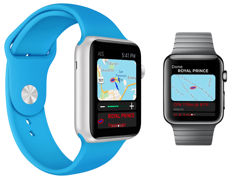
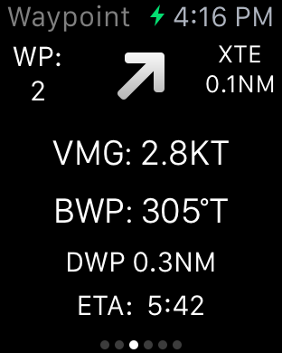
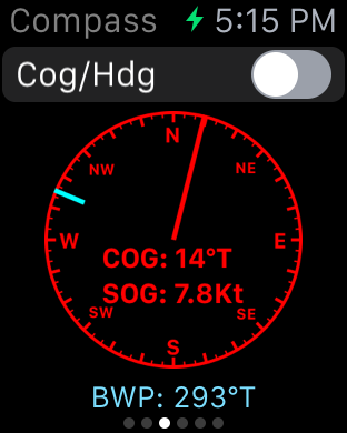
2. You need Boat Beacon on your iPhone/iPad to be in Sailing mode (Sailing button bottom left selected) to get  SOG, COG , Heading and CPA/AIS information on Boat Beacon’s watch app display. The same applies to our SeaNav Watch app which also has a Waypoints display.

3. iPhone Battery is draining much faster when SeaNav or Boat Beacon app has been run on  my watch even though it is no longer being displayed on the watch and I am not running the apps on my phone/iPad.

The problem is that when you launch the SeaNav or Boat Beacon watch app (or in fact any app that needs gps) on your watch it stays running even when its not showing on the watch face and/or another app (e.g. the clock) is showing. As it is running it will keep asking the iPhone for gps info which will eat battery on your iPhone. The solution is to “Force stop” the SeaNav app on your Watch when you have finished using it. Here’s how to do this:-

With the SeaNav/Boat Beacon app showing on your Watch screen press and hold the side button below the Digital Crown for a few seconds. The next screen you see features buttons for Power Off, Power Reserve and Lock Device. When you see this screen press and hold the side button again until you see SeaNav disappear and be replaced by the home screen.  There are more instructions for how to do a force stop here

We need a way to exit the SeaNav app on the watch more easily – either from the iPhone or more directly from within the SeaNav app running on the watch. This appears to be a mistake/oversight by Apple (a lot of folks with fitness and cycling apps are complaining to Apple about battery drain) and hopefully they will address it in a future release.

Just remember to force quit it on your Watch when you don’t need it running.

4. The wrist torch mode doesn’t work – looks like Apple won’t let the watch show a blank white screen (it worked in the simulator). We will take a look at how to get this working. For now you can use the AIS Map display to shed some light in the dark.

5. The watch screen is polarised to reduce glare and visibility is good on a bright day.  Apple have got the polarisation right – just like on instrument displays on aircraft –  it works fine with Polarised sunglasses. We tested with a pair of my son’s Ray-Ban Aviators and we could see the watch face fine. seanav-watch


Independent trials of the Pocket Mariner AIS Dual channel receiver.

With the help of a ShipPlotter user in Finland we have been able to run side by side tests of our Pocket Mariner Dual Channel AIS receiver with a mainstream commercial brand AIS receiver costing over 3 times the price. We are very pleased with the results, with the Pocket Mariner Dual Channel AIS receiver achieving almost exactly the same coverage/range/data rate of the well known commercial brand. Here are some stats comparing our Pocket Mariner AIS receiver on port 7018 (blue) and the other on port 5378 (red ) and screenshots at the same time of the coverage from the same aerial in Helsinki.

Rate of data received (bits/s)

Screen Shot 2015-06-13 at 10.58.10

We also found that the coverage/range for both the commercial AIS receiver and ours was significantly improved using a relatively in-expensive AIS frequency (162MHz) tuned filter and pre-amp on the aerial feed. We used and would recommend the VHF Pre-amp from Spectrum Communications (formerly known as the Garex pre-amp). They start at around £15 for the pcb built one and around £50 for a boxed version. The ship ranges in the screenshots below is approximately 150km (100Miles).  The tropospheric conditions were good.

7018 Pocket Mariner Dual Channel AIS Receiver coverage snapshot


Screen Shot 2015-06-13 at 10.45.42


5378 Commercial AIS Receiver coverage snapshot

Screen Shot 2015-06-13 at 10.45.53

N.B. The buoys at the top of the screen (North) are over 350km away and most likely Synthetic Aids To Navigation being broadcast by a shore based station nearer our aerial.

If you are interested in having a Pocket Mariner Dual Channel AIS receiver please get in touch with us at . support@pocketmariner.com


Row around Singapore Island (RASI), Mission to Seafarers and Boat Beacon AIS tracking

Pocket Mariner are very pleased to be sponsoring the  Row around Singapore Island  in aid of the Mission to Seafarers .

A group of 40 enthusiasts from the maritime and insurance community in Singapore have come together, to undertake a 24 hour endurance sea challenge, all in aid of the global maritime welfare charity, The Mission to Seafarers.

Mission Row Around Singapore Island (RASI), will see two teams in ocean-going rowing boats attempt the 140km journey, taking on the seas and shipping lanes (not to mention two live military firing ranges) to complete a non-stop circumnavigation of the island of Singapore. The event itself will be held during the 50th anniversary year of Singapore’s independence and will also coincide with Singapore Maritime Week on the 22nd / 23rd April, 2015.

Pocket Mariner have provided their Boat Beacon app to both teams so they can share their position and speed during the event and everyone will be able to follow their progress on our live group tracking web view service.

http://boatbeaconapp.com/portwatch/missionrasi.html. If you would like to add the view to your own web page you can use the following iFrame:-

<iframe src=”http://boatbeaconapp.com/portwatch/groupwatch.php?group=MISSIONRASI&drawtools=1&embed=1&groupgetotherships=0″></iframe>


If you are organising an event or a race and are interested in having live tracking available please contact us :- support@pocketmariner.com

Watermark Round Britain Voyage Summer 2015 and Boat Beacon AIS

Watermark is a Beneteau First 33.7 Cruiser/ Racer  currently on a round Britain voyage.  She is using Boat Beacon to share her position over internet AIS with friends and family on Boat Watch and our new live iframe “embed” web page that lets you add a map showing your boat’s location to other web pages (e.g. a blog). Use the following as a template, you can set the width and height to fit your page

“<iframe style=”border:none;height:600px;width:1800px;” src=”http://boatbeaconapp.com/see/MMSI?embed=1″></iframe>”

Where MMSI is your boat’s MMSI number (as set in Boat Beacon). If you don’t have an MMSI, we can provide you with an internet AIS one, or you can use your Boat Beacon identity instead starting with BB (see the bottom of My Boat Details in Boat Beacon to find your Boat Beacon id). If you don’t have  blog or web site you can also give out a web link to your web page on our site – e.g. http://boatbeaconapp.com/see/MMSI

We wish Malcolm and Watermark a safe and very enjoyable circumnavigation and look forward to following their progress. Here is his current postion :-


Apple Watch – Pocket Mariner apps

We have been working hard to ensure Apple Watch versions of all our marine apps are ready for you as soon as you get your new Apple Watch. Boat Beacon, our signature app, now gives you collision alerts directly on your wrist with CPA time and distance information and a map overview. Check your next waypoint wherever you are on your boat with a compass view, cross track error (XTE), distance and ETA on our SeaNav watch app.  Spot nearby boats, track your ferry or a boat of interest and get arrival and departure alerts with our Boat Watch app on Apple Watch.


PocketMariner_SeaNav_on_Apple_Watch_aPanbo-thumb-465xauto-11115

SeaNav and Boat Beacon Navigation view


iOS Simulator Screen Shot - Apple Watch 16 Mar 2015 16.15.02


SeaNav Waypoint face.


iOS Simulator Screen Shot - Apple Watch 16 Mar 2015 16.16.59


Boat Beacon and SeaNav Compass view


iOS Simulator Screen Shot - Apple Watch 16 Mar 2015 17.15.53


Boat Watch, Boat Beacon and SeaNav map AIS view

iOS Simulator Screen Shot - Apple Watch 16 Mar 2015 17.41.07


As ever – ship photos to help you identify it.

iOS Simulator Screen Shot - Apple Watch 16 Mar 2015 17.49.20


And the great news ….. the watch apps are all free upgrades to our existing apps 🙂

Melbourne to Port Fairy Ocean Yacht Race

Pocket Mariner are pleased to be sponsoring the  ORCV’s (The Ocean Racing Club of Victoria) Melbourne to Port Fairy Ocean Yacht Race this Easter. We are providing complimentary copies of our Boat Beacon app to all the entrants and race officials so they can track the fleet over the 135 mile race.

You can view and see the tracks for all the boats live here

http://boatbeaconapp.com/group/ORCV 2015 PORT FAIRY

We have also set up 5 Artificial Aids to Navigation for the start and finish of the race, marking Drapers Reef at the start line, ORCV Virtual Buoy, Point Lonsdale Light, Corsair Rock  and Nunn buoy at the finish line.

The AtoN’s are visible in Boat Beacon and our Boat Watch apps.

IMG_3740


You can read more about the AtoNs for the race on the ORCV web site here:-

http://www.orcv.org.au/index.php/port-fairy/4413-boat-beacon-ais-smartphone-tablet-app-aids-to-navigation

New AIS Aerial in the Caribbean on St Barts

Our latest AIS aerial  on St Barthelemy in the Caribbean has just gone live. If only I could go out and test it! Thanks to Emmanuel at Jicky Marine Service

http://boatbeaconapp.com/station/7017

Screen Shot 2015-03-25 at 16.07.12


Our AIS aerial on top of Jicky Marine Service’s office.

FullSizeRender (3)


Jicky Marine’s office from the other side of the Harbour


FullSizeRender (4)


Plan of Gustavia  looking from the land side out to sea (North is bottom right) showing the office location.


New AIS Aerial at Davidstow Airfield, Cornwall

As part of the ongoing work to improve our global AIS coverage we have installed a new AIS aerial to provide better real time coverage for the seas around Cornwall in the UK.  There is a disused airfield at Davidstow. It was Coastal Command’s highest airfield in the UK at 300m (1000′) above sea level; a perfect place to get a long range view of the surrounding sea,  to the North, West and South of Cornwall.  We used a Digital Yacht AIS Net base station for the AIS receiver with a Shakespeare 6db AIS tuned aerial. There is no internet connection at the museum so we used a Huawei E3551 3G dongle and the excellent EE 3/4G data service to backhaul the AIS data to our servers.  You can check the live coverage from the new aerial here:-  http://boatbeaconapp.com/station/5353

Here is my son installing the aerial on the tower at the airfield.

image1


The DY AIS receiver hooked up at the base of the aerial.


image2


and live ships –  10,000 square miles of coverage including two major ports at Falmouth and Plymouth 🙂

Screen Shot 2014-10-07 at 16.56.24

Many thanks to Steve at Davidstow Airfield and Cornwall at War Museum who is kindly letting us use his tower to mount the aerial on  (giving us another 12m (40′) of elevation 🙂 . The museum is very well worth visiting if you are in the area and even if you are not.

Transas iSailor app now powered by Pocket Mariner’s live AIS service

Pocket Mariner’s real time AIS data and photo API service has been selected by Transas , a global leader in marine navigation systems, to use with their iSailor iPhone and iPad app. The latest version 1.7.0 of their app  now provides a real time map view of ships around you with instant details including name, range and bearing together with a photo of the ship to help you recognise it.

You can get the latest version of  iSailor from the app store now

IMG_0022           Mikhail Andrianov, Product Manager at Transas says “We are really excited to provide our Transas iSailor users with live AIS data on their charts via the Internet. Pocket Mariner’s live AIS API, SDK and sample code made integration with our product easy and fast. This option makes it possible to show on charts the next AIS target types: AIS Class A, AIS Class B, AtoN (Aids-To-Navigation, virtual or real), Shore Base Stations. This functionality will be useful for users of different kinds: from sailors, boaters or water tourists, – who have no AIS Class B or receivers on board to ship owners, dockers and marine logistics personnel, who need to monitor vessel traffic in a given area. To use this functionality, you will have to have WiFi, 3G or 4G/LTE internet access on your Apple device.” Steve Bennett, Pocket Mariner’s CEO commented: “This is another great endorsement of Pocket Mariner’s “real time” AIS data service and API’s that we use to power our own Marine Navigation Apps and we look forward to providing additional AIS data services enabling Transas’ iSailor users to share their boat’s position and course in real time using our internet AIS transmit and track api’s”.   IMG_0052