Vessel Motion and Position Monitoring in real-time with AISWatch telematics

Pocket Mariner’s AISWatch service now provides Real-time Remote Vessel Motion Monitoring and situation reporting (RTR-VMM). RTR-VMM enables significant improvements to operations efficiency and vessel utilisation with a direct impact on profitability.

Let marine co-ordinators for Wind Farm and Oil rig services optimise operations from base by knowing real time whether the conditions on the support ships are within the safety parameters for personnel and equipment transfer.

Cruise line operators can check the comfort level for their passengers and see if they are having a bad experience with the ship rolling too much or if the ship is running into serious waves and pitching fiercely?

Check the view right now from the Ship’s bridge deck  back at the operations centre. Share the glorious port arrival, sunset and sunrise views from a cruise ship’s bridge deck on the web with current passengers and potential customers.

Instantly know where your ship is and what other vessels are nearby in real-time anywhere in the world.

Remotely monitor equipment, environment and engines on the ship.

Continue reading “Vessel Motion and Position Monitoring in real-time with AISWatch telematics”

Marine Navigation with FLIRONE Augmented Reality

Augmented Reality with FLIR ONE

MORNING_CALM_BB_AR_FLIR_IOSPocket Mariner collaborated with Practical Boat Owner to successfully complete a demanding night time sea trial of our popular marine navigation apps, SeaNav HD and Boat Beacon with the  FLIR ONE Thermal Imager for iOS; a new, low cost , infra-red thermal imaging camera for the iPhone.  The FLIR ONE makes thermal imaging affordable and accessible to a much wider audience at a fraction of the cost of the higher end marine IR imaging devices. Pocket Mariner have ingeniously integrated the live thermal image with their widely acclaimed iOS Augmented Reality mode providing identification, distance and bearing of the ships and Aids To Navigation in view at night and in fog.  We wanted to see how well and how far off we could spot ships via their infra-red signature and if the FLIR ONE could help with searching for a Man Overboard (MOB).

Practical Boat Owner, the UK’s leading boating magazine, bravely deployed their editors, David Pugh and Ben Meakin, together with Ben’s Impala 28 yacht , “Polly” and intrepid “Woman Overboard” volunteer, Laura, along with Pocket Mariner’s CEO, Steve, on a pitch black night in Southampton water.

Here’s what we saw.

Continue reading “Marine Navigation with FLIRONE Augmented Reality”

SailTimer Wind Instrument, SeaNav and Pebble SmartWatch

Some of SailTimer’s customers asked them if their bluetooth WindInstrument would work with Pocket Mariner’s  SeaNav Marine Navigation app and if the wind information could also be displayed on our free SeaNav Pebble watch companion app. So SailTimer asked us and now it does…
diag copy
windinstruments
The SailTimer WindInstrument is completely wireless, no power of data lines, so the install is far simpler than for other marine wind vanes.  It is the first masthead anemometer  with a digital compass built into the wind direction arrow so you get true wind direction even when docked or at anchor. It sends the wind data via bluetooth and is solar powered with 24 hour running. The WindInstrument if fully weather and waterproof (submersible) and has innovative wind cup blades design to maintain equal accuracy when sailing heeled over.

Continue reading “SailTimer Wind Instrument, SeaNav and Pebble SmartWatch”

ShipPlotter AIS sharing to Boat Beacon and Pocket Mariner

Its very easy to set up using the UDP/IP peer to peer sharing feature in ShipPlotter’s I/O settings. See screenshots below. Select enable in the UDP/IP peer-to-peer output, enter the IP address 54.204.25.151 and Remote Port number 5322 (see area circled in red).

ShipPlotterBoatBeacon

Click OK when finished. You will return to the main program window. Click on the “Start” button and you should then see your data on this web page:-

N.B. If you would like your own dedicated UDP port number and web view to share to please email us at support@pocketmariner.com

Dual Channel VHF AIS receiver for under $35 – Boat Beacon, AIS Share and RTL-SDR

Screenshot_2016-03-03-09-53-17 (1)

Got an Android phone? Want Screen Shot 2016-03-04 at 12.32.24a dual channel VHF AIS receiver for under $35? Now there is one thanks to our Boat Beacon app and the Android AIS Share app from ebcTech! All you need is  an RTL-SDR USB dongle,  an android OTG cable , the AIS Share app and our Boat Beacon app and you can see all the ships out to 30NM away (depending on height above sea level). No need for an internet connection, this is a  truly standalone full featured AIS receiver and with Boat Beacon’s new NOAA US Marine charts you have an AIS chart display with Collision detection and alarms too. It takes just a couple of minutes to set it up the first time and then after that it works out of the box. Here is what you need:-

The RTL-SDR USB stick is a software programmable radio receiver and because of its popularity for use in picking up TV and fm radio broadcasts it is incredibly cheap. As low as $10.  It is so powerful it can pick up and demodulate both AIS VHF frequencies at the same time. The one we recommend is the RTL-SDR.COM stick which is around $25  and has several major improvements over generic brands including use of the R820T2 tuner, improved component tolerances, a 1 PPM temperature compensated oscillator (TCXO), SMA F connector, aluminium shielded case with thermal pad for passive cooling and a telescopic aerial that you can extend to the correct length for AIS reception – 44.4 cm.

Next you need an Android OTG cable that lets you attach the RTL-SDR USB dongle to your Android device. They are typically less than $4 and we recommend the Y shapeScreen Shot 2016-03-04 at 12.36.44d ones which allow you to keep your device charging at the same time as using the RTL-SDR dongle. N.B. It is important that you connect the power and the RTL-SDR dongle to the Y cable first before connecting it to your device otherwise it won’t charge the device – there is a video about this here:-  https://m.youtube.com/watch?v=rXiyzfP94AU Make sure you have our Boat Beacon downloaded and installed . Next download and install the AIS Share app from the Play Store. Set up of AIS Share is pretty straight forward .

Installation / First start

Install the driver app from Google PlayTM store. Get it on Google Play https://play.google.com/store/apps/details?id=eu.ebctech.rtl_sdr_ais_driver Start it one time. After that you can close the app ( RTL SDR AIS Driver ) Install AIS Share Get it on Google Play https://play.google.com/store/apps/details?id=eu.ebctech.ais_share Start the AIS Share app go to the setting activity

AisShare Dongle Settings

Set the PPM setting This is really important. For the RTL-SDR.COM USB stick that we recommend this will always be 0 as it comes with a stable pre-tuned oscillator. Google it Set up the UDP Share Start the driver with the pink floating action button.(please do not start / stop too fast , if you have clicked one time .. wait a second ) AisShare start Then check if you are receiving messages. Finally, launch Boat Beacon, go to settings, scroll down to Local AIS, select UDP, then tap on Local AIS Port and enter 10111. AIS Share will continue to run in the background as long as the USB dongle is attached. Watch the ships sail by 🙂 Screenshot_2016-03-04-12-12-06
Screenshot_2016-03-03-09-53-17 (1)

Independent trials of the Pocket Mariner AIS Dual channel receiver.

With the help of a ShipPlotter user in Finland we have been able to run side by side tests of our Pocket Mariner Dual Channel AIS receiver with a mainstream commercial brand AIS receiver costing over 3 times the price. We are very pleased with the results, with the Pocket Mariner Dual Channel AIS receiver achieving almost exactly the same coverage/range/data rate of the well known commercial brand. Here are some stats comparing our Pocket Mariner AIS receiver on port 7018 (blue) and the other on port 5378 (red ) and screenshots at the same time of the coverage from the same aerial in Helsinki.

Rate of data received (bits/s)

Screen Shot 2015-06-13 at 10.58.10

We also found that the coverage/range for both the commercial AIS receiver and ours was significantly improved using a relatively in-expensive AIS frequency (162MHz) tuned filter and pre-amp on the aerial feed. We used and would recommend the VHF Pre-amp from Spectrum Communications (formerly known as the Garex pre-amp). They start at around £15 for the pcb built one and around £50 for a boxed version. The ship ranges in the screenshots below is approximately 150km (100Miles).  The tropospheric conditions were good.

7018 Pocket Mariner Dual Channel AIS Receiver coverage snapshot


Screen Shot 2015-06-13 at 10.45.42


5378 Commercial AIS Receiver coverage snapshot

Screen Shot 2015-06-13 at 10.45.53

N.B. The buoys at the top of the screen (North) are over 350km away and most likely Synthetic Aids To Navigation being broadcast by a shore based station nearer our aerial.

If you are interested in having a Pocket Mariner Dual Channel AIS receiver please get in touch with us at . support@pocketmariner.com


Pocket Mariner live AIS Coverage

Our ship tracking network uses a global network of shore and ship-based radio stations, which receive signals from the AIS system that ships use to broadcast their positions as they travel. Our receiver stations share the ship positions with our cloud-based data server, which pushes them onwards and out to our apps and web services.

We are continuously working on increasing the coverage of our real-time AIS receiver station network. During the last three months we have added more than 100 new AIS stations across 5 continents bringing our live ship coverage to over 40,000 ships. We have supplied the AIS receiver for free for many of these sites. New volunteers are always welcome to join our AIS Network.

Here is a  list of the most recent stations we have set up  and a snapshot of our global coverage Q2 2019

America

Hudson Bay, NJ
Sakonnet River in Rhode Island
St Lawrence Seaway
British Columbia
Miami, Florida, US (2 new stations)
Antioch, CA.
Stockton,CA
St Bartholomew (Caribbean)
Dominian Republic.
Buenaventura, Colombia.
Lake Erie
Several stations in Uruguay
Several stations in Mexico

Europe

The whole of Norway
The whole of Denmark
The whole of Finland
Scicily, Italy
Turku, Finland
Maasbracht, Netherlands
Ijsselmeer, Nethrlands
Ust-Luga, Russia
St Petersburgh, Russia
Edinburgh, Scotland
Over 30 new stations in and around Sweden.
Eastbourne, UK
Scilly Isles, UK
Isle of Man, UK
Lowestoft, UK
Alicante, SP
Faro, Portugal

Africa

Port Harcourt, Nigeria.
Canary Islands
Dakar, Senegal

Middle East

Kuwait
Dubai

Australasia

Perth, Adelaide, Darwin, Australia
Nagoya, Osaka, Inland Seas, Japan
Singapore
Indonesia
Ho Chi Min City, Vitenam
Sihanoukville, Cambodia.

If you are interested in adding coverage for your area, please read our Cover Your Area information – we can often provide the equipment free of charge.

Nautical Apps for Apple Watch

Sailors and boating enthusiasts now have nautical apps on Apple Watch

Wales, UK – Pocket Mariner has launched Apple Watch versions of its popular nautical apps, Boat Beacon, SeaNav and Boat Watch. These apps put powerful real-time navigation and boat tracking maps on the wrists of sailors and boating enthusiasts. With the Apple Watch being splash-proof and water-resistant, it makes a great companion device for boaters when combined with the new apps by Pocket Mariner.

“Fast access to key information and tools has been our philosophy when designing the new Apple Watch versions of our nautical apps,” said Steve Bennett CEO of Pocket Mariner. “Our goal is for boaters and boating enthusiasts to be able to quickly access information directly on the watch without fumbling for their phones.”

Boat Beacon

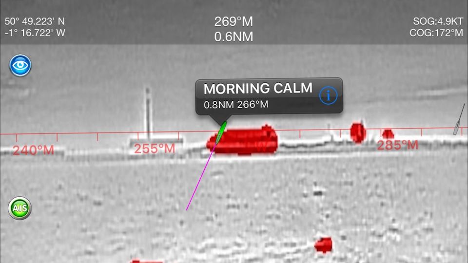
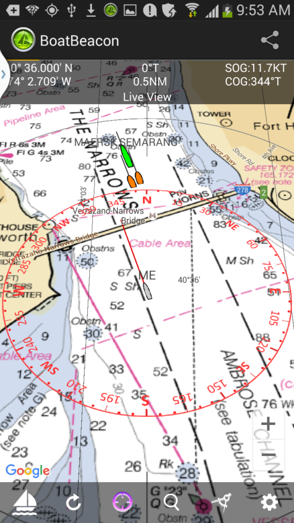
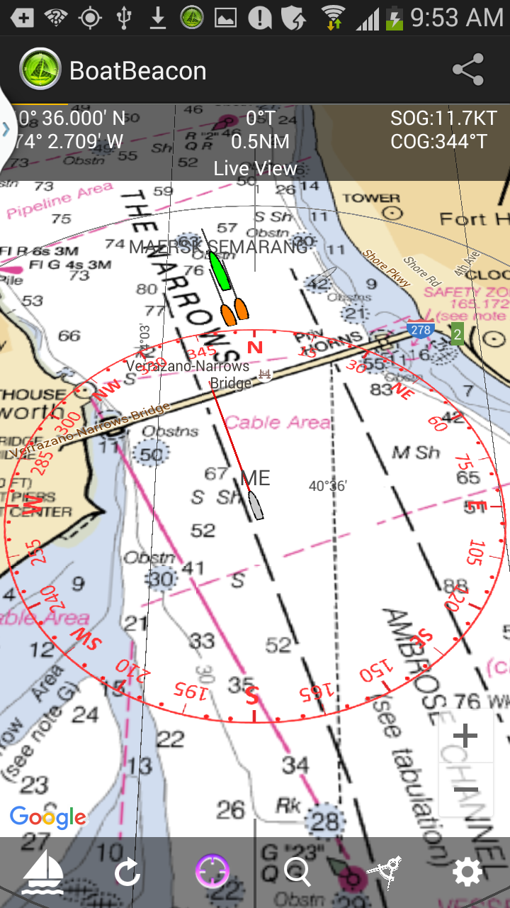
Boat Beacon is an app that allows sailors to monitor other boat positions, receive alerts for potential collisions and share their own position via internet AIS.

Boat Beacon for Apple Watch adds a wrist view of the user’s boat position, collision alerts and a handy set of navigation and boating tools. Boat Beacon on Apple Watch has five top-level screens: A Map screen, showing the user’s boat position and those of nearby boats; a Navigation screen showing speed and course, and which offers an emergency “Man Over Board” button; a Race Timer screen; a Compass screen; and a final screen which operates as a useful mini-flashlight, with day and night modes.

SeaNav

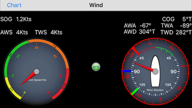
SeaNav is Pocket Mariner’s popular marine navigation and charting app. The new Apple Watch screens in SeaNav include waypoint navigation tools, compass, AIS and collision avoidance and a race timer.

SeaNav uses the latest Digital Vector charts, providing a wealth of benefits and advantages over raster charts. The app provides details, distance and bearings of buoys, lights, bridges, depth contours, depth soundings, rocks, anchorage areas, and NOAA weather buoys. Other useful information available in SeaNav includes tides, moon and sun times and weather.

When at sea, SeaNav provides features for navigating the course. The app alerts sailors when they’ve reached each waypoint, plus provides auto-routing to the next waypoint. SeaNav also keeps sailors safe at sea by providing collision alerts.

Boat Watch

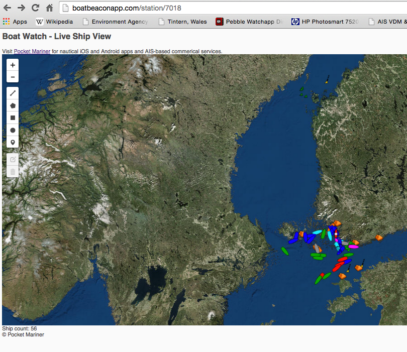
Boat Watch, a leading “ship tracking” app, allows users to follow movements of ships and vessels anywhere in the world. The app has grown increasingly popular with people visiting coastal or river ports, who have friends or family at sea, or who rely on catching a ferry or boat as part of their daily routine. Boat Watch has been enhanced with an Apple Watch map display showing boat movements in real-time.

On the Apple Watch, Boat Watch will display a list of boats they are following, and users can tap for details on the boats with a full color photograph. The map region matches the parallel maps in the Boat Watch iOS app, so that users can follow boats either locally or anywhere of interest around the world. Users can also follow a list of favorite boats, and check on their watch where they are.

Having access to this information instantly on their wrist will make it very easy and convenient for a user to see if their ferry is on schedule or where a loved one’s cruise ship currently is. Users have the option to receive alerts on their watch when their tracked boat arrives or departs port.

All of Pocket Mariner’s nautical apps with free Apple Watch support are available now for download on the App Store.

For more information, visit PocketMariner.com.


Row around Singapore Island (RASI), Mission to Seafarers and Boat Beacon AIS tracking

Pocket Mariner are very pleased to be sponsoring the  Row around Singapore Island  in aid of the Mission to Seafarers .

A group of 40 enthusiasts from the maritime and insurance community in Singapore have come together, to undertake a 24 hour endurance sea challenge, all in aid of the global maritime welfare charity, The Mission to Seafarers.

Mission Row Around Singapore Island (RASI), will see two teams in ocean-going rowing boats attempt the 140km journey, taking on the seas and shipping lanes (not to mention two live military firing ranges) to complete a non-stop circumnavigation of the island of Singapore. The event itself will be held during the 50th anniversary year of Singapore’s independence and will also coincide with Singapore Maritime Week on the 22nd / 23rd April, 2015.

Pocket Mariner have provided their Boat Beacon app to both teams so they can share their position and speed during the event and everyone will be able to follow their progress on our live group tracking web view service.

http://boatbeaconapp.com/portwatch/missionrasi.html. If you would like to add the view to your own web page you can use the following iFrame:-

<iframe src=”http://boatbeaconapp.com/portwatch/groupwatch.php?group=MISSIONRASI&drawtools=1&embed=1&groupgetotherships=0″></iframe>


If you are organising an event or a race and are interested in having live tracking available please contact us :- support@pocketmariner.com

Watermark Round Britain Voyage Summer 2015 and Boat Beacon AIS

Watermark is a Beneteau First 33.7 Cruiser/ Racer  currently on a round Britain voyage.  She is using Boat Beacon to share her position over internet AIS with friends and family on Boat Watch and our new live iframe “embed” web page that lets you add a map showing your boat’s location to other web pages (e.g. a blog). Use the following as a template, you can set the width and height to fit your page

“<iframe style=”border:none;height:600px;width:1800px;” src=”http://boatbeaconapp.com/see/MMSI?embed=1″></iframe>”

Where MMSI is your boat’s MMSI number (as set in Boat Beacon). If you don’t have an MMSI, we can provide you with an internet AIS one, or you can use your Boat Beacon identity instead starting with BB (see the bottom of My Boat Details in Boat Beacon to find your Boat Beacon id). If you don’t have  blog or web site you can also give out a web link to your web page on our site – e.g. http://boatbeaconapp.com/see/MMSI

We wish Malcolm and Watermark a safe and very enjoyable circumnavigation and look forward to following their progress. Here is his current postion :-