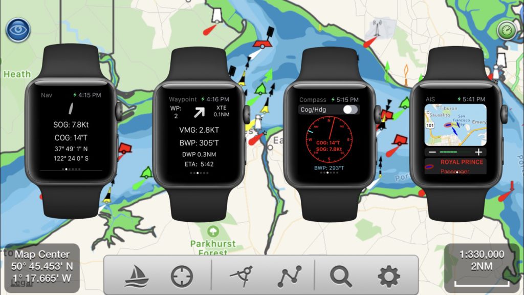
Unlike other Marine Navigation apps on the AppStore, SeaNav comes with a really useful and free Apple Watch App which shows live navigation information, waypoints, compass, wind display and AIS radar. Waypoint reached and CPA (AIS collision) alerts also show up on your Apple Watch.
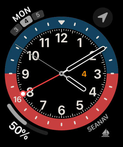
You can add a launch complication for SeaNav to your main Watchface, so you can tap and go straight to SeaNav.
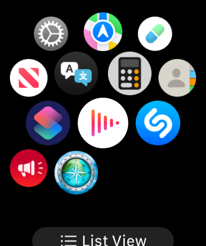
You can also launch SeaNav by tapping its icon in the Apps view on the watch
Stop and start sailing a route by tapping the boat icon with the cross on it.
SeaNav is now Sailing the currently selected route with the boat symbol showing the heading. SeaNav on your iPhone will also now be in Sailing mode recording your track etc.
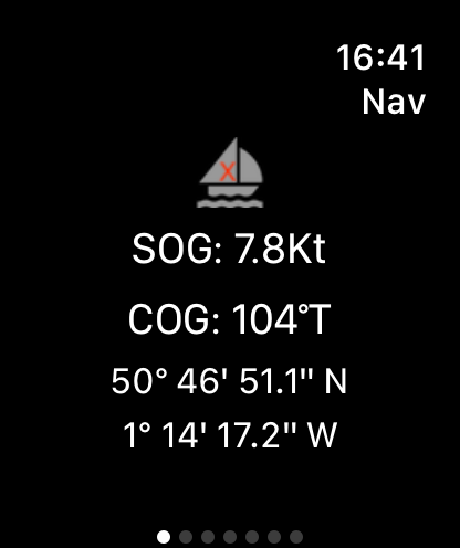
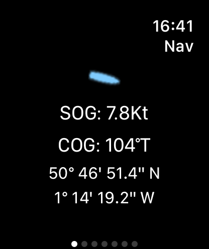
Navigation display
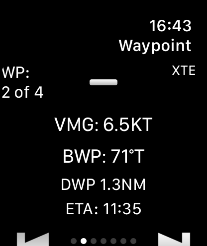
Swipe left to view the WayPoint display. This shows the current Waypoint number, Cross Track error (XTE) and direction to turn to get back on track , vector made good (VMG), bearing to waypoint (BWP) and distance to Waypoint (DWP). You can jump to the previous or next waypoint using the arrows at the bottom of the screen.
Waypoint display
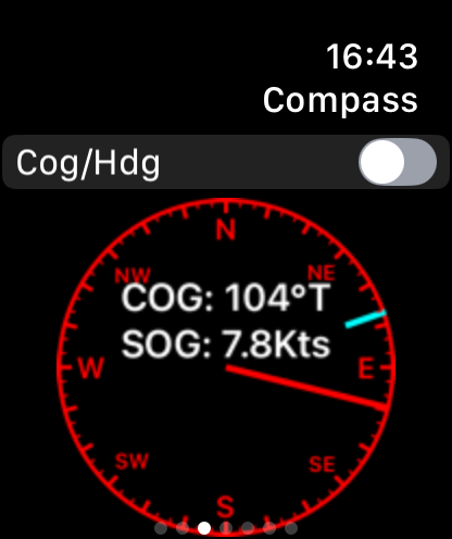
Swipe left again to view the compass showing heading (or course over ground (cog)) with a blue line showing the route direction.
Compass display
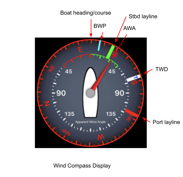
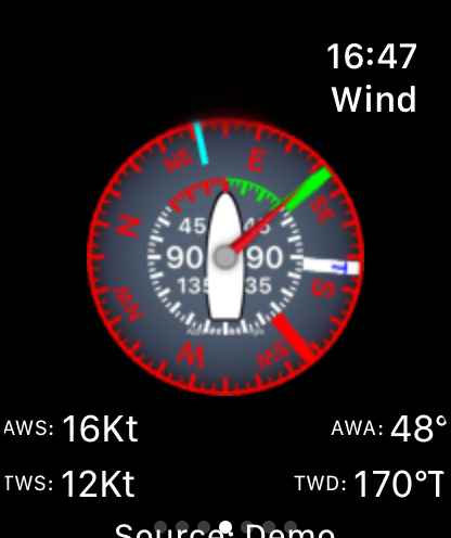
Next up is the wind display. This shows a compass with boat heading up, true and apparent wind direction plus the port (red) and starboard (green) laylines ( for sailing). The bearing to the next waypoint is also shown in light blue. The wind display can either use NMEA wind data from a wind instrument on board via Wifi or the current local wind data from the SeaNav live internet weather service (IAP).
Wind display
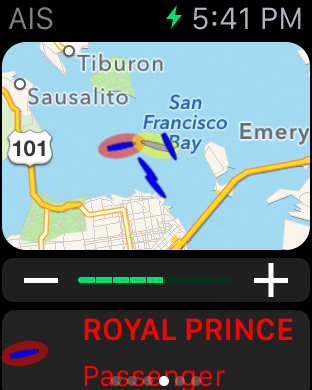
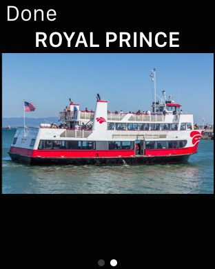
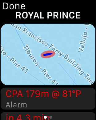
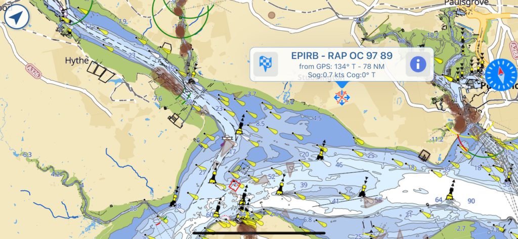
Finally you can check the boats around you with the AIS Map display. CPA boats are shown with a red circle on the map and in red in the scrollable list below. Tap on an item in the list to get more info and a photo.
AIS Map display.
You can try all these features for free in simulation mode with the SeaNav app which is free to download from the AppStore.
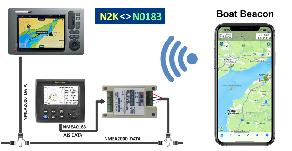
View realtime AIS on your boat’s Multifunction Display (MFD) without an AIS receiver and aerial or improve and extend your local VHF AIS reception with over the horizon and “instant on”* internet AIS. Boat Beacon can share its real time internet AIS data via Wifi and NMEA2000 (or 0183) to MFDs like Garmin, SIMRAD/B&G/Lowrance and Raymarine.
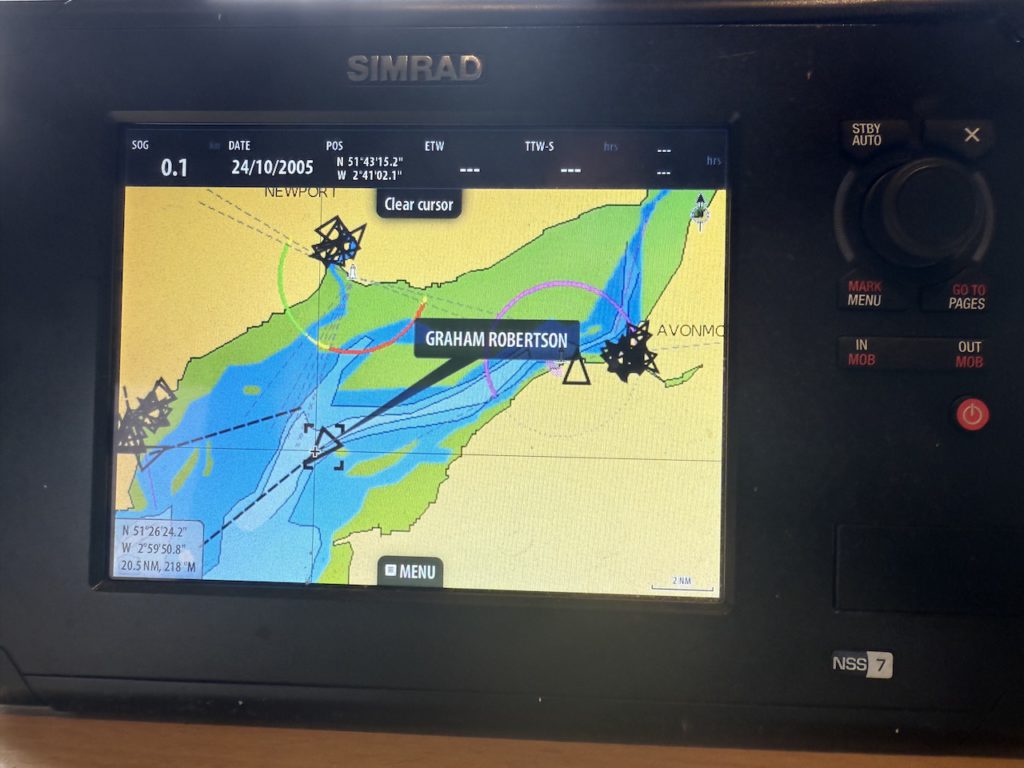
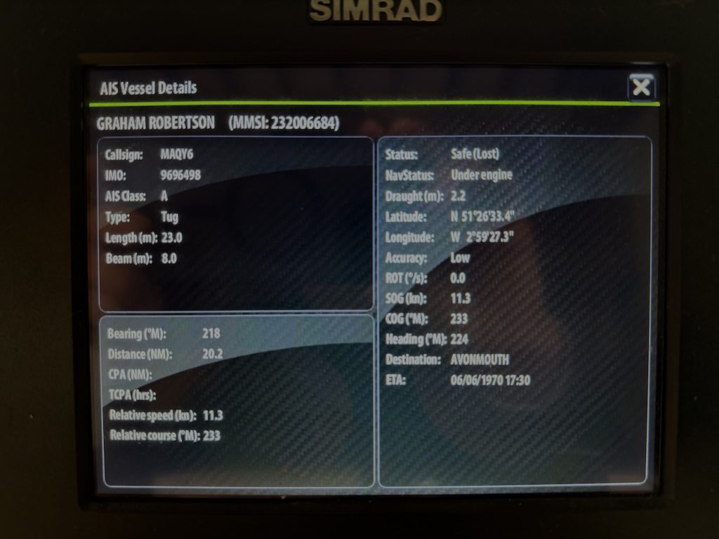
Here is Boat Beacon on an iPhone using Wifi to send its live AIS data to a SIMRAD NSS MFD over NMEA2000 via the N2K0183 adapter.
Here’s how to configure the N2K0183 device with Boat Beacon running on iOS. (Android instructions here). The Boat Beacon AIS data will be received via cellular and sent out over the boat’s NMEA2000 network. You will need the Boat Beacon AIS Share feature enabled (demo mode or IAP). Also make sure you have the latest firmware for the N2K0183 – v2.8 or later. N2K0183V28.BIN (July 2025)
Connect the N2K0183 to the boat’s NMEA2000 network.
Next connect your iPhone to the N2K0183’s Wifi network (SSID N2K0183 password 12345678) and use Safari or Chrome on your iPhone to browse to http://192.168.4.1 to view its setting page.
Set the WIFI ports settings TCP to 2001 and check the TCP to N2K checkbox.
IMPORTANT: If you are using the N2K0183 in “USE N2K0183 AP ONLY” mode, which is the default, you need to change the SSID (top left of the settings page ) to N2K0183:NG.
Using N2K0183:NG as the SSID lets iOS know it cannot use the N2K0183 Wifi connection for internet data. It ensures the iPhone/iPad will still use its cellular connection to connect to the internet and fetch AIS data etc.
Finally tap the blue SET button to set the configuration.
If you have changed the SSID you will need to search and reconnect the iPhone to the new SSID (e.g. N2K0183:NG )Wifi network.
N.B. If you don’t have NMEA2000 on board and want to use and output NMEA0183 check the TCP to P2 checkbox on the N2K0183 and set the Serial Ports Settings for P2> to 38400.
Now launch Boat Beacon and go to Settings. Make sure AIS Sharing is On ( requires demo mode or an IAP) . Next tap the AIS & GPS Link row to configure the connection to the N2K0183.
Set the port to 2001, the Host to 192.168.4.1 and the switch to tx
Then tap Start and you should start to see live AIS data being sent.
Make sure Boat Beacon is set to Sailing mode so that it keeps transmitting even when in background (e.g. screen off). Now check your MFD display connected to the NMEA2000 network and see the live ship positions around you.
If you have a WiFi network on board with internet both Boat Beacon and the N2K0183 can connect via that instead so that Boat Beacon can use that connection instead of your iPhone’s cellular data. Configure the N2K0183 to connect to the boat’s Wifi network ( set the SSID and password and set mode to “ALSO CONNECT TO EXTERNAL”. Then tap the blue “SET” button. The N2K0183 will restart and get an IP address on the Boat’s Wifi network. Note this IP address, it is displayed just under the N2K<>N0183 banner (e.g. 192.168.1.173 – you can still connect to the N2KNMEA via 192.168.4.1 if you want or need to).
With your iPhone connected to the same boat’s Wifi network (e.g. STARLINK) set Boat Beacon’s AIS & GPS Link to send to the N2K0183’s boat’s wifi IP address instead of 192.168.4.1 (e.g. 192.168.1.173) and then tap Start.
You can purchase the N2K0183 NMEA2000 Wifi gateway from here. Other NMEA2000 wireless servers like the DigitalYacht NAVLINK2 , Quark-Elec, Actisense etc. will also work with Boat Beacon to share its live AIS data to your MFD.
*”Instant on” refers to the instant static ship data ( name, type, size etc.) that you get with Boat Beacon’s internet AIS feed whereas with VHF AIS it can take up to 6 minutes to receive a vessels static message and view the info.
Here’s how to configure the N2K0183 device with Boat Beacon running on Android. The Boat Beacon AIS data will be sent out over the boat’s NMEA2000 network.
Connect the N2K0183 to the boat’s NMEA2000 network.
Next connect your Android device to the N2K0183’s Wifi network (SSID N2K0183 password 12345678) and use Chrome to browse to http://192.168.4.1 to view its setting page.
Set the WIFI ports settings TCP to 2001 and check the TCP to N2K checkbox.
If you don’t have NMEA2000 on board and want to use and output NMEA0183 instead check the TCP to P2 checkbox and set the Serial Ports Settings for P2> to 38400.
Finally tap the blue SET button to set the configuration.
Now launch Boat Beacon and go to Settings. Make sure AIS Share is enabled ( requires IAP with 3 day free trial) .
Next tap the Local AIS row to configure the connection to the N2K0183.
Select TCP AIS TX
The Local AIS Host and Port fields will now show and need to be set.
Set the port to 2001 and the Host to 192.168.4.1
Now go back to Boat Beacon’s map view and make sure Boat Beacon is set to Sailing mode (sailboat icon bottom left selected) so that it keeps transmitting even when in background (e.g. screen off or viewing another app). Now check your MFD display connected to the NMEA2000 network and see the live ship positions around you.
If you have a WiFi network on board with internet both Boat Beacon and the N2K0183 can connect via that instead so that Boat Beacon can use that connection instead of your phones cellular data. Configure the N2K0183 to connect to the boat’s Wifi network ( set the SSID and password and set mode to “ALSO CONNECT TO EXTERNAL”. Then tap the blue “SET” button. The N2K0183 will restart and get an IP address on the Boat’s Wifi network. Note this IP address, it is displayed just under the N2K<>N0183 banner (e.g. 192.168.1.173 – you can still connect to the N2KNMEA via 192.168.4.1 if you want or need to).
With your Android device connected to the same boat’s Wifi network (e.g. STARLINK) set Boat Beacon’s Local AIS to send to the N2K0183’s boat’s new wifi IP address e.g. 192.168.1.173 instead of 192.168.4.1.
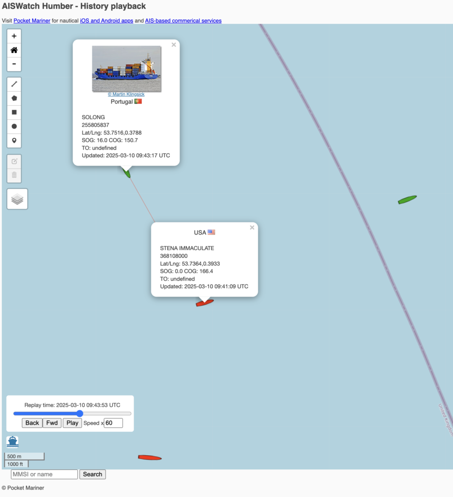
We monitor the Humber Windfarms with our AISWatch service and captured the collision today between Solong ( cargo ship in green) and the Stena Immaculate ( oil tanker in red).
You can watch the AISWatch replay of the incident in 3D here:-
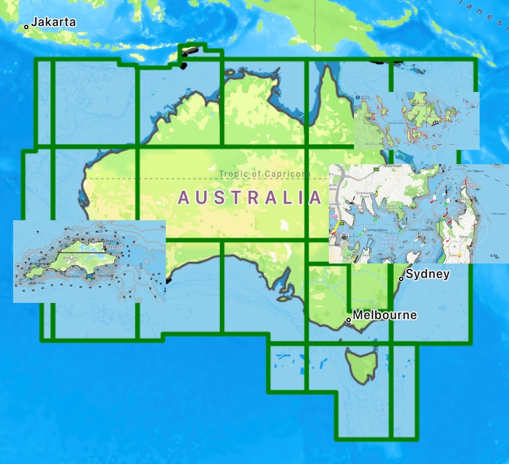
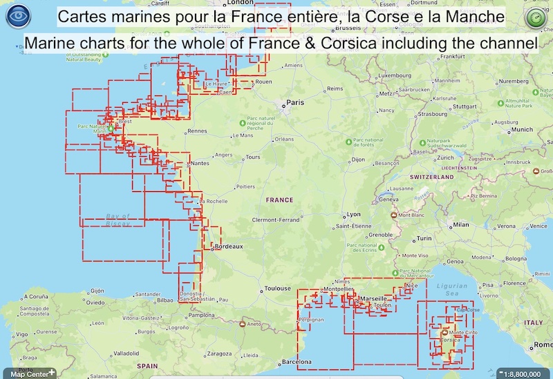
Australian and French vector (ENC) charts are now available for SeaNav.
The French charts include live tidal stream information up to 7 days ahead, especially important for the northern coast and channel. Here is an example for the Golfe du Morbihan in Britanny where PocketMariner’s Captain has personally experienced the very fast tidal flows :-
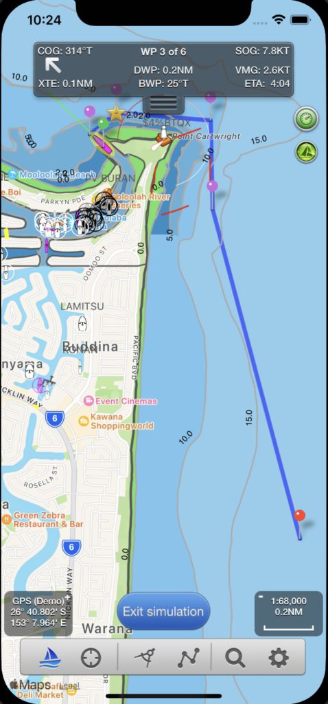
The free version of SeaNav has demo routes which let you try all the advanced features such as AIS (collision detection), Weather, Wind and Depth displays, Tidal Streams, Augmented Reality and of course the charts for free. New demo routes have been added for France and Australia. The demo route for Australia is from Mooloolaba on the Sunshine Coast:-
You can get SeaNav for iPhone, iPad and Apple Silicon Macs free from the AppStore here now:-
There is a great short video by “East Coast Sailing” which recommends our Boat Beacon & SeaNav apps, and includes a very novel and useful way of using a SeaNav route to plan and explore the weather (wind and waves) on the route using full screen Windy on a laptop. Well worth the watch.
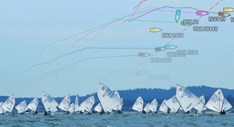
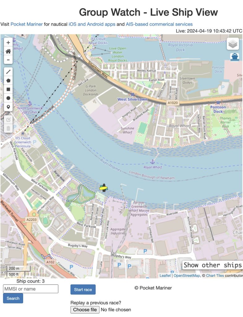
You can now track, record and replay races with Boat Beacon on Android and iOS using groups and the following web page:-
https://boatbeaconapp.com/ais/race/MYGROUPNAME
Where MYGROUPNAME is your group name. The group hashtag name is anything you like up to 20 capital letters (no spaces). Set your group name in Boat Beacon/Settings/My Trip Details.
The initial view shows the last know position of all boats in the group. Click on “Start race” to show and track live positions. A race timer displays how long the race has been running for. Click on “Stop race” to end and save the race information to a local file.
When you stop the race two timestamped files are exported to your local desktop, a .kml file that can be used to view the tracks in Google Earth and a .geojson file which can be re-loaded up to the web page to replay the race using the “Choose file” button.
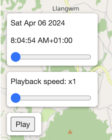
When a previously recorded race is loaded the following controls appear
A slider to fast forward and back through the race and tracks. A Playback speed slider to set the speed of the playback and a Play/Stop button. Click the Play button to start replaying the race from the slider position. There is also a checkbox top right “GPS Tracks” to turn the tracks on and off.
Here is the PocketMariner YC page – currently both boats ashore.
We are looking for early adopters to gather feedback on what other features or improvement could be made to make the new Group Race feature useful. Please let us know if you try it and how you get on by emailing help@pocketmariner.com with the subject “Group races”.
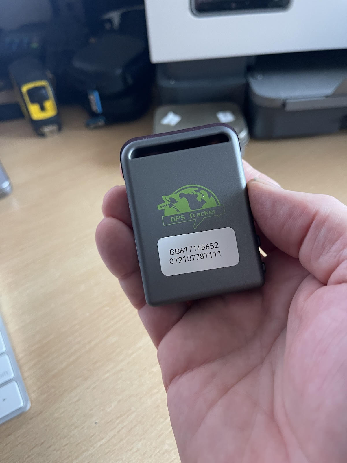
We are also looking at the possibility of tracking yachts and dinghies during club races using inexpensive small GPS trackers like the one below as an alternative to having the Boat Beacon app and are looking for a volunteer Yacht club to try this with.
The basic idea is for the tracker and sim card to be cheap enough for a club to have enough of these devices to hand out to all race participants who don’t have Boat Beacon so they can follow the tracks of all participating yachts and dinghies on screen at the club house and review the race afterwards.
Our tests of the trackers show they can run for around 12 hours on one charge with position updates every 5s (12m accuracy at 5 Knots). We have sourced non-expiring IoT data sim cards which work on all networks with enough data pre-installed for 5 million fixes. We are now looking to try with real races and need a volunteer Yacht club based in the UK. We will supply the trackers for the trial at cost and the service for free. The raw cost per GPS tracker device including the lifetime sim card is around £75. If you are interested please contact help@pocketmariner.com with the subject “Race Trackers”.
Get live AIS ship positions around you on the Aqua Map app with Boat Beacon’s virtual AIS receiver.
Boat Beacon can now share its real time AIS feed from our global AIS aerial network via NMEA with Aqua Map on the same device or on the same Wifi Network. Boat Beacon acts as a “Virtual AIS Receiver” and is the first and currently only app out there that offers this .
The new Boat Beacon AIS Share feature is free to try in demo mode. If you find it useful you can use it any time when you are out boating for a small monthly or annual subscription via IAP. The Aqua Map AIS feature requires their Master subscription IAP for AIS and Wifi connections which comes with a 14 day free trial.
You can get the latest version of Boat Beacon from the Apple App Store here and Google PlayStore here. Aqua Map is available for iOS here and on Android here
This is a step by step guide on how to configure Boat Beacon AIS Sharing with Aqua Map on iOS. The guide uses Boat Beacon’s demo mode so you can try for free at home away from the coast and without having to purchase an AIS sharing subscription.
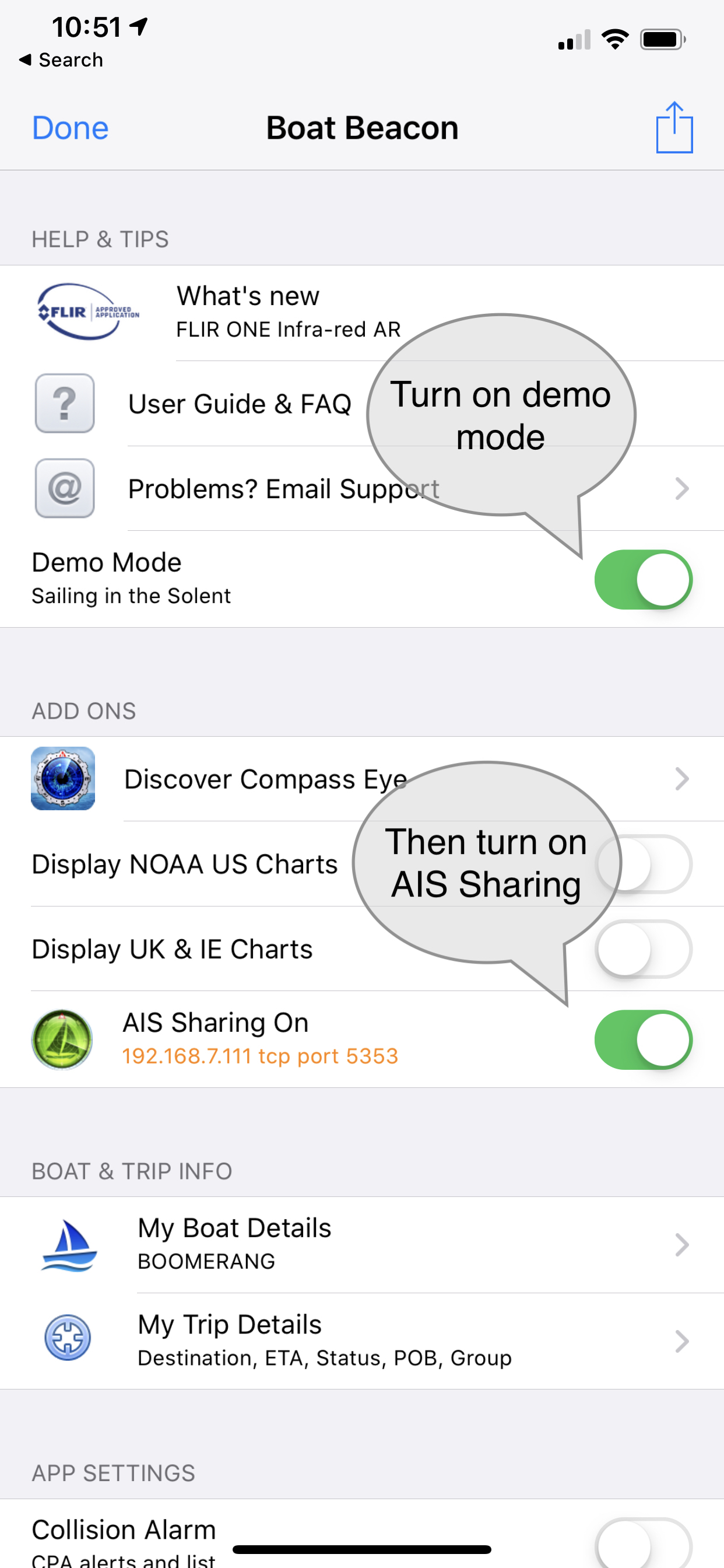
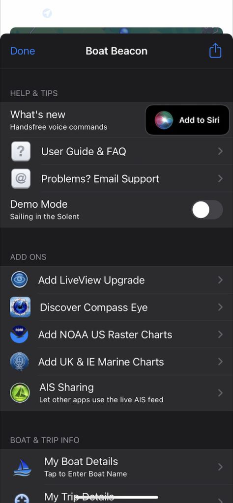
1. Launch Boat Beacon and go into Boat Beacon settings and turn on “Demo Mode”, then turn on AIS Sharing. It will show the default TCP port number to use 5353 and will be orange ( not connected). N.B. If you are not in the UK the demo mode will be centred on San Francisco bay in the US or other locations.
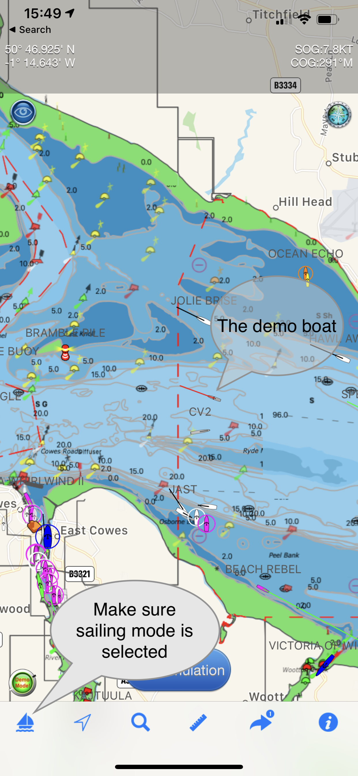
2. Tap Done top left and go back to the chart view. This will position the map on a virtual boat in the Solent ( or San Francisco Bay). All the other boats in view are real and live. Tap the sailboat icon bottom left to start sailing the demo route.
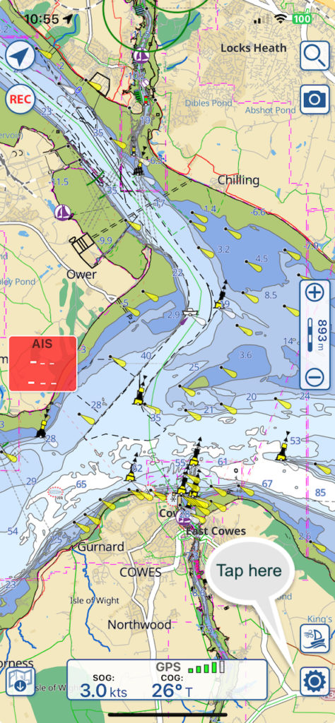
3. Now switch to the Aqua Map app (on the same device) and position the chart on the Solent ( or San Francisco Bay) and then tap Settings wheel bottom right so you can configure AIS.
Scroll down to “Wi-fi connections”
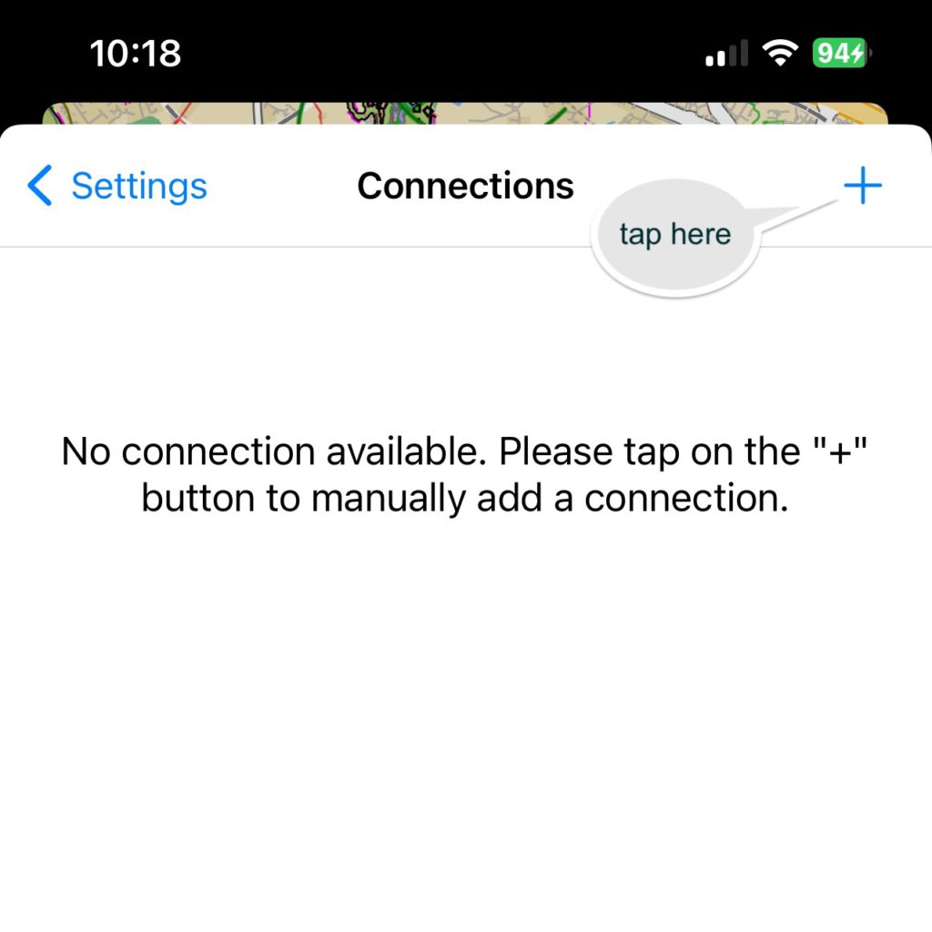
You should then see the Connections screen*, tap “+” at the top right
(* If you already have a device set up you can add another by tapping the + at the top right on the device list screen.)
Select”Boat Beacon app”. This will automatically configure the settings
Tap “Save” top right and go back to the map view. You should now see live AIS boat and ship icons ( brown triangles and circles on the map) and even a SART Alarm in the screenshot below
Now every time you run Boat Beacon in Sailing mode Aqua Map will automatically connect and receive the live AIS data from around your GPS location out to 30NM.
Notes on setting up AIS Sharing:
When using Demo mode to try AIS Sharing out for free you have to position Aqua Map to the same location as Boat Beacon is simulating at – e.g. the Solent for EU, San Francisco for US, Lübecker Bucht for Germany and Sydney harbour for Australian users
Boat Beacon must be in Sailing mode to maintain the AIS feed when it is in the background ( e.g. when you are viewing the Aqua Map chart) on your device.
Make sure you have Location sharing for Boat Beacon set to “While using” in your device Privacy/Location settings. Please note Boat Beacon will only use your location when it is running ( foreground) or in the background when in Sailing mode.
You do not need to have a WiFi connection to your device to use Boat Beacon and Aqua Map on the same device. While Aqua Map will run completely offline you must have an internet connection though (e.g. Cellular/Mobile) to receive Boat Beacon’s AIS data.
You can share to Aqua Map on other devices too if they are on the same local WiFi network using the IP address shown in Boat Beacon’s AIS Sharing setting instead of 127.0.0.1 in the Aqua Map Connection setting.
iOS14 has introduced a new privacy permission if apps want to use localnetwork resources which Aqua Map needs to have set to yes. The OS will prompt you the first time either app tries to use a connection. You can manually set/change the permission in your device’s Settings/Privacy/Localnetwork.
Might sound obvious, but it has caught a couple of people out. You need to subscribe to the monthly or yearly Boat Beacon AIS Sharing feature via IAP ( tap the AIS Sharing row in Settings to bring up the IAP screen) to use Boat Beacon with Aqua Map when not in demo mode. Also Aqua Map needs their iAP (Master subscription) for using AIS and WiFi Connections.
If you have any questions or problems getting it working please email us at help@pocketmariner.com
Collision Avoidance
The primary purpose of AIS is monitoring and alerting for potential collisions. Boat Beacon’s AIS service has two key advantage, instant ship details and over the horizon detection ( out to 30NM). With VHF AIS only the MMSI number, position and speed appear initially and it can take up to 6 minutes for the ship names and type details to be received. With Boat Beacon the names, size and type are available instantly with position so you can call them up by name over VHF radio and check their intentions. VHF AIS receivers can only see as far as the visual horizon which is typically about 12NM whereas Boat Beacon’s multiple shore antennas at high elevation can provide coverage out to 30NM in popular areas.
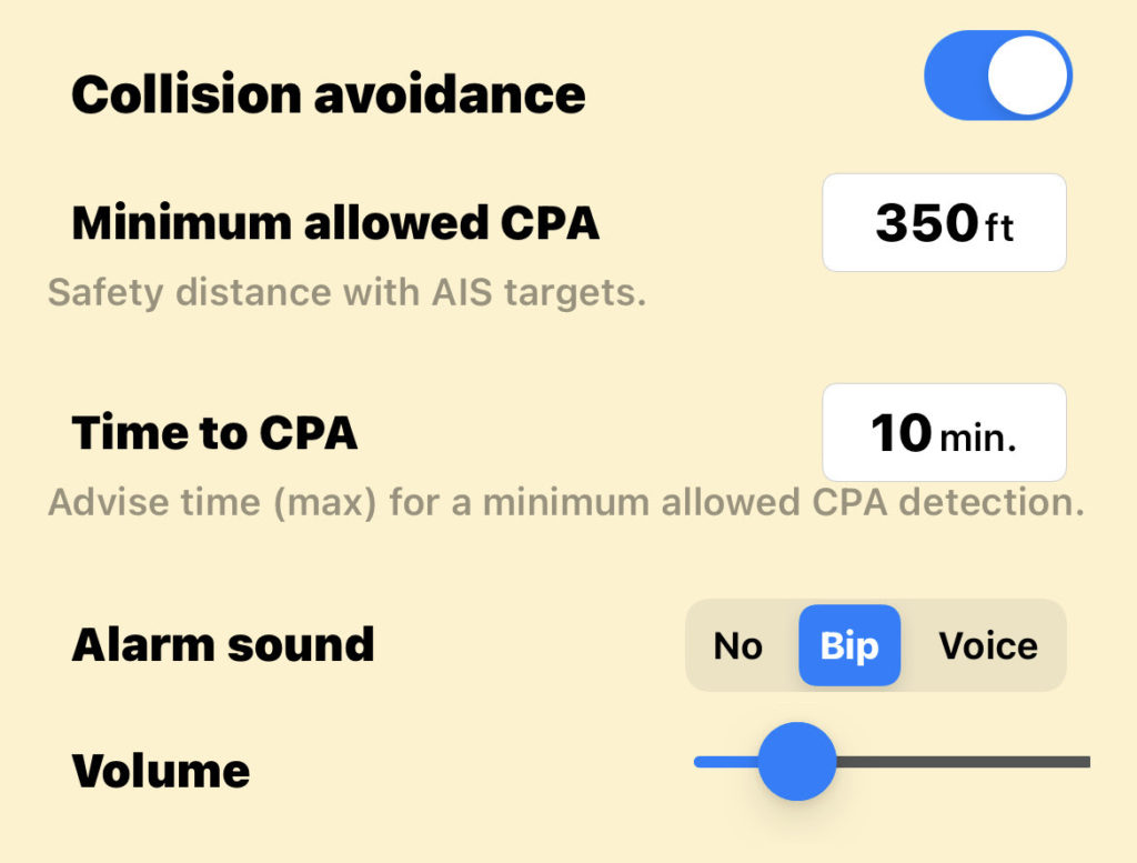
Boat Beacon has configurable options for collision detection distance, time and alerting in Settings.
You can also configure collision avoidance alert parameters in Aqua Map’s settings:-
Collision avoidance: to enable the alarms related to the Collision avoidance (red flashing color for the colliding targets, AIS box red flashing, sound alarms, …).
Minimum allowed CPA: to select the CPA (Closest Point of Approach = minimal distance 2 boats will be if following same direction and speed) below which a target is considered colliding. This calculation is done for the time specified in the “Time to CPA” field. In the example above this means that an alarm will be fired if any boat will be closer that 350 ft to our boat in the next 10 minutes. NOTE: the collision is calculated considering the GPS position received and a hypothetical boat size (size of the boat in AIS data is frequently unknown or unreliable). So for big boats this could lead to undetected collisions.
Time to CPA: to define the maximum time in the future for which you would search a possible collision.
Alarm sound: to select the type of sound alarm you would receive each time a new collision is detected.
Volume: to select the volume for the alarm sound you selected.
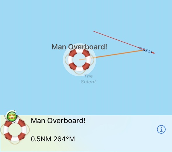
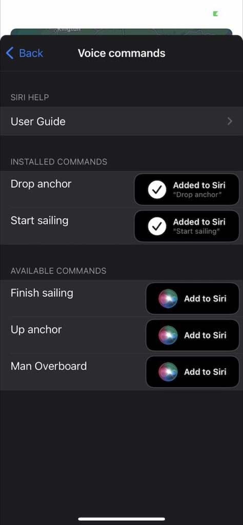
As the new boating season starts we have added a new, unique and useful feature for our popular Boat Beacon app – “Hey Siri, Man Overboard”
Boat Beacon now supports several Siri voice commands which you can use with your device or on your Apple Watch (requires iOS 12 or later and WatchOS7 or later). This lets you use Boat Beacon’s features hands free. The current list of voice commands are:-
“Man Overboard “- Toggles Marking and tracking a man overboard position with Boat Beacon
“Start Sailing” – put Boat Beacon into “On boat” mode. Same as tapping the Sailboat icon bottom left
“Finish Sailing” – Turn off Boat Beacon “On boat” mode.
“Drop Anchor” – Mark your anchor position and set a drift zone around it.
“Up Anchor”- removes the Anchor watch.
“Navigation status” – report current speed, course and heading.
You can add the commands to Siri from the Boat Beacon app in settings or directly in the Siri App itself. They work directly with Siri without having to mention “Boat Beacon” in the command. You can also customise the commands to respond to your own preferred phrases or language.
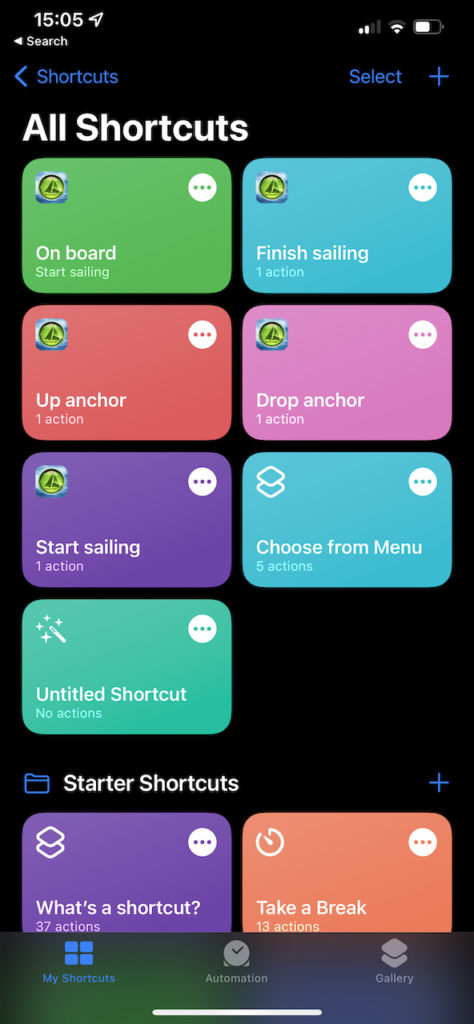
Tap the Add to Siri button in Boat Beacon settings to see the list of commands that are active and more that you can add. “Drop anchor” and “Start sailing” have been added in the screenshot. To add another command just tap its “Add to Siri” button. Once added you can ask Siri to do them at any time on your device or your Apple Watch.
You can also edit the commands that have been added by tapping the “Added to Siri” button next to them and add additional speech commands to launch them. For instance add “On board” as an addition/alternative to “Start sailing. You can type the phrase or enable dictation and speak it. Useful also for setting phrases in other languages or using alternative phrases that Siri finds it easier to understand.
You can view and delete the commands in the Siri Shortcuts app on your phone. Once added the commands work automatically on your Apple Watch, no more set up required. If you want to see them in the actual Siri app on your Apple Watch as well then you can set “Show on Apple Watch” in the Shortcut settings in the Siri app on your phone.
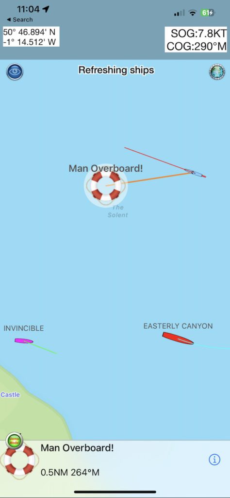
Try it now. Add “Man Overboard” and then say “Hey Siri, Man Overboard” to your iPhone/iPad or your watch. It will sound an alert, mark the position and start tracking it for you.
Say “Man Overboard” again to clear the alert. N.B. This will still leave Boat Beacon in sailing mode.
There is a User guide in the app and online here:-
Our ship tracking network uses a global network of shore and ship-based radio stations, which receive signals from the AIS system that ships use to broadcast their positions as they travel. Our receiver stations share the ship positions with our cloud-based data server, which pushes them onwards and out to our apps and web services.
We are continuously working on increasing the coverage of our real-time AIS receiver station network. During the last three months we have added more than 100 new AIS stations across 5 continents bringing our live ship coverage to over 80,000 ships. We have supplied the AIS receiver for free for many of these sites. New volunteers are always welcome to join our AIS Network.
Here is a list of the most recent stations we have set up and a snapshot of our global coverage Q1 2022
America
Hudson Bay, NJ
Sakonnet River in Rhode Island
St Lawrence Seaway
British Columbia
Miami, Florida, US (2 new stations)
Antioch, CA.
Stockton,CA
St Bartholomew (Caribbean)
Dominian Republic.
Buenaventura, Colombia.
Lake Erie
Several stations in Uruguay
Several stations in Mexico
Europe
The whole of Norway
The whole of Denmark
The whole of Finland
Scicily, Italy
Turku, Finland
Maasbracht, Netherlands
Ijsselmeer, Nethrlands
Ust-Luga, Russia
St Petersburgh, Russia
Edinburgh, Scotland
Over 30 new stations in and around Sweden.
Eastbourne, UK
Scilly Isles, UK
Isle of Man, UK
Lowestoft, UK
Alicante, SP
Faro, Portugal
Africa
Port Harcourt, Nigeria.
Canary Islands
Dakar, Senegal
Middle East
Kuwait
Dubai
Australasia
Perth, Adelaide, Darwin, Australia
Nagoya, Osaka, Inland Seas, Japan
Singapore
Indonesia
Ho Chi Min City, Vitenam
Sihanoukville, Cambodia.
If you are interested in adding coverage for your area, please read our Cover Your Area information – we can often provide the equipment free of charge.