![]()
We’ll be at the METS trade show in Amsterdam next week – November 19th -21st . Come and meet us, see our apps and try out the Pebble Smartwatch too – METS 2013 – Stand(s):01.120, 01.147

![]()
We’ll be at the METS trade show in Amsterdam next week – November 19th -21st . Come and meet us, see our apps and try out the Pebble Smartwatch too – METS 2013 – Stand(s):01.120, 01.147
Our unique AR view mode allows you to view buoys, lights, ships, waypoints and track overlaid on your iPhone or iPad live camera view. With “AR LockOn” you can select a target on the chart and then be guided to it in the AR camera view.
Find that ship on the horizon and instantly see its name, range and bearing.
Spot the next marker buoy.
Tap the “eye” icon at the top left to switch AR mode on, then tilt your device up to see a live camera of the scene and boats around you. As you turn round and view buoys and ships, their name, range and bearing will popup when they are in the center of the view. You can also tap on them to get more information. Tilt back down to see the map view. Tapping the “eye” icon again turns AR mode off. You can pinch to zoom the map or camera views.
In AR mode our unique “AR Lock On” feature lets you select a ship or buoy on the map view and then easily locate it in the Camera view using a grey arrow to tell you which way to turn to spot it when its not directly in view. Your course (yellow line) and route to next waypoint (blue line) will also be visible overlayed on the camera view.
Ships are color coded based on their type e.g. Sailing boats are white, Pleasure Craft magenta, etc. See the Map Legend for full details. A vector points forward showing where each boat will be in 2 minutes time based on its current Speed and Course. Ships move in real time across the map and in the AR view. Tap on a ship or buoy to get more information and tap on the right arrow to get even more including speed, course, distance, bearing, picture etc. The horizon is set by the zoom scale of the chart view – e.g. zoom out on the chart view to see further out in the Augmented reality view.
AR photo from the Isle of Wight ferry.

SeaNav now hooks up with the amazing Pebble Smartwatch to provide live navigation data on your wrist wherever you are on your boat. Check Speed, Course, Waypoint, Wind, AIS radar, SailSteer and times and get Collision(CPA), Waypoint and Countdown timer alarms. The SeaNav Pebble Smartwatch app is free. Read more in the SeaNav Pebble user guide and get the free App via the Pebble Watch setting in SeaNav.


Our network of AIS coverage around the world is amongst the best in the industry. However we are always looking to add new areas and improve existing ones.
Thanks to John Ambler on the Isle of Wight sharing his AIS data directly to our servers our users now have greatly improved real time coverage around the Solent and English Channel.
Here’s a screenshot showing the range of ships his receiver is picking up from an aerial 200 feet above sea level on the island.

You can check the live coverage on John’s web page and in real time on Boat Beacon and SeaNav too.
http://www.john-ambler.com/ais/google.html
A big thank you to John and complimentary copies of all our marine apps.
")
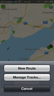
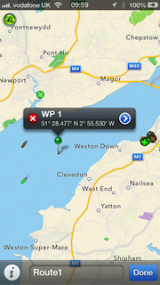
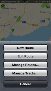
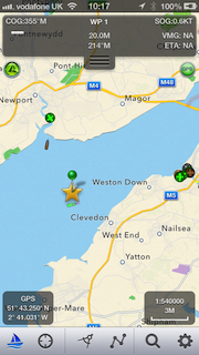
We took Sarita, my 27′ catamaran out to test the latest versions of SeaNav and Boat Beacon at sea in the Bristol Channel. The planned route was a 6 hour passage on the ebb tide from Chepstow to Cardiff (see SeaNav route plan below). 3 persons on board; Captain Keith Avery of the RSS Discovery ( see the excerpt from Sarah Casey’s book – the Wave ) , our Vicar, also an ex-merchant navy officer and myself. Illustrious company.
The trip went well and to plan until we were just off Portishead where strong wind against tide made the going very uncomfortable and slow. As we didn’t have to get to Cardiff that day we decided to stop over in Portishead. Boat Beacon transmitted our position faithfully and my family tracked our progress live on our Boat Watch app and the web ( http://boatbeaconapp.com/go/MMSI ). Captain Avery helmed most of the way and was impressed with our apps. Check the screenshots below for the route, track and web views. The blue line and pins are the planned route and waypoints, the white dotted line is the recorded track. You can see the exact pontoon we tied Sarita up at in Portishead Dock!


![]()
We have now launched our new Boat Beacon companion app, Boat Watch.


Boat Watch is a free app, which offers…
* Spot any Boat or Ship via real-time AIS
* See the Name, Type and Destination of each vessel
* Set any boat as your favoirite, and automatically track it on the map
* Search and find boats and places
* Share boats on Facebook, Twitter or by email
Optional One-time In-App Upgrade Purchase adds…
* Get alerts when your favourite boat arrives or departs
* Full boat information – speed, course, country, etc.
For Boat Beacon users, Boat Watch is a great app to tell your friends and family about so they can follow your voyage.
Boat Watch is a Universal app, which works on iPhone, iPod and iPad.
As part of the Boat Watch launch we are sponsoring the Ahoy Centre Totally Oarsome! charity – which challenges you to test your abilities, get fit and raise money for the Ahoy charity to help others.

Let your family , fr![]() iends and supporters follow you in real time on their iPhone, iPad or iPod as you take on AHOY’s ultimate rowing challenge.
iends and supporters follow you in real time on their iPhone, iPad or iPod as you take on AHOY’s ultimate rowing challenge.
Pocket Mariner are sponsoring the Ahoy Centre by providing every rowing team with a free copy of their Boat Beacon AIS tracking app. All you need to do is enter your team name in the boat details, then invite your family, friends and supporters to follow you in the FREE Boat Watch app. Tap the Sail button in Boat Beacon to start tracking. Boat watchers will be able to see your position and track updated continuously as well as all the other boats around you. See the screen-shots above for an idea of what you can see on the Boat Watch app.
With the Boat Watch In-App purchase option for only £1.99, family, friends and supporters are able to monitor your speed, course, destination and ETA details. They also get automatic alerts on their iPhone, iPad or iPod when you start and finish or stop midway!
All proceeds from the In-App purchases during the challenge will go to the AHOY Centre.
We had some great feedback from one of our users, Ken, in Southern California:-
I have now been using Boat Beacon in the southern California waters for the past few months and really enjoy the visibility it provides me. Just this past weekend, my Yacht Club had a large cruise over the 4th in Catalina and in my trip over, I had a cargo ship that, based on Boat Beacon CPA data, going to get really close. I called the ship, by name, on VHF Channel 16 and based on the conversation, he changed course, which again we had a conversation with him telling me what he had planned to do etc.
It is exactly that type of data that made my trip along with a lot of others.
My question is; I have an assigned MMSI and Transmitting from the iPad, I “see” the ships, do they “see” me on their shipboard system? I know I can be seen on ship finder, Marine Traffic, but not sure if they see me in real time on their system.
BTW; a number of my club members who were in transit had heard my call and discussion and came away impressed with what Boat Beacon can do. A number of them have already downloaded it onto their apple IOS and Android devices.
In answer to Ken’s question, if you are only transmitting your position using Boat Beacon then the ships will not be able to see you on their VHF AIS Systems. However many of the Coast Guard stations and Harbour/Port Authorities around the US, UK and Australia do now combine internet AIS feeds with their local VHF AIS data, so there is a good chance you will be showing up on their screens.
")
Check out the pictures these guys are posting on their Twitter feed…
https://twitter.com/
Sheerness Lifeboat!