Quark-Elec AIS receiver review and Boat Beacon

For inshore (less than 10NM from the coast) our real-time internet AIS service for Boat Beacon and SeaNav has a lot of advantages over VHF AIS receivers and reception, it is very cheap, easy to install (no aerial required), easy to use and provides incredible range including “seeing” round corners and over headlands and islands. However if you venture further afield and go out of range of internet coverage, for instance when half way across the English channel between Southampton and Cherbourg and in the main shipping channel you need a VHF AIS receiver!

Many of our Boat Beacon and SeaNav users use our apps both for internet AIS and as a display and CPA alert device for their on-board VHF AIS receiver. There is a new and relatively inexpensive range of AIS receivers out on the market from Quark-Elec and also the dAISy. They are less than a quarter of the price of the usual AIS receivers from the likes of Digital Yacht, Comar and Weatherdock etc. . We wanted to try them out for use with SeaNav and Boat Beacon on iPad and iPhone.

iOS does not support USB connections so to get local AIS data into your iPad you need to connect via Wifi and will need an AIS receiver with Wifi built in or get a USB to Wifi adaptor. There are no USB to to wifi adaptors available on the market! It is possible to build your own for around £50 using a Raspberry Pi or BeagleBone Black as we have done but for this comparison this rules out USB only AIS receivers such as the dAISy unfortunately.

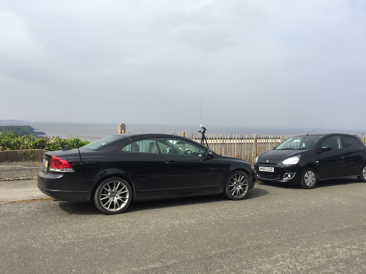
We drove out to nearby Dial hill in Clevedon overlooking the Bristol Channel at a height of approximately 100m above sea level. At this height the VHF horizon should be around 32NM for spotting ships. We used a standard marine 1/4 wave whip  AIS aerial (£50) on a tripod and our SeaNav app on a laptop in the car to run a comparison test to see how the Quark-elec compared to the Digital Yacht AIS receivers that we normally use.

ais_tests

and the view

IMG_1487

First off the devices:-

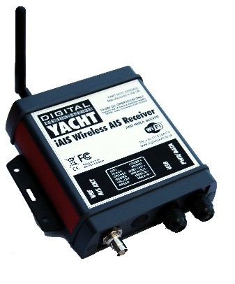
The dual channel Digital Yacht AIS wireless receiver at around £365.  http://www.cactusnav.com/digital-yacht-iais-wireless-receiver-p-11569.html. This also allows you to attach other NMEA data such as wind, speed and depth etc. to your iPad via the Wifi channel.

iais web
The Quark-elec A026 Wifi enabled AIS and GPS receiver at £94.79 . http://quark-elec.com/products/marine/147-qk-a026

A026_System_diagram

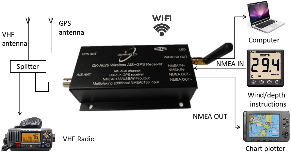
This looks like an amazing device as it also includes a GPS receiver and a NMEA multiplexer so you can combine data from Wind instruments, Speed log and Depth over Wifi too. You can get one without GPS for £79 – the QKA-024. So price for price this is less than a quarter of the price of the Digital Yacht equivalent!
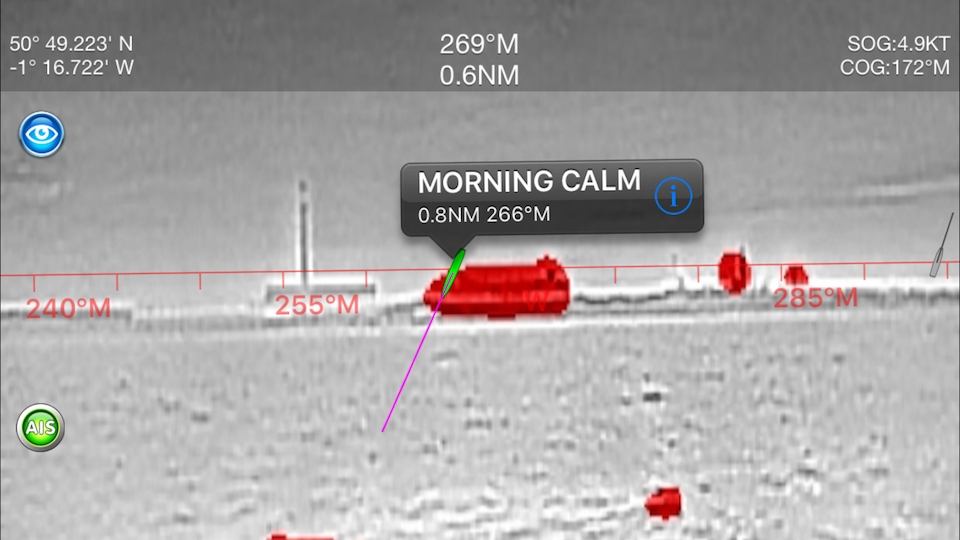
The results

Quark-elec A-026

QuarkA026Screen Shot 2017-05-06 at 11.06.38

Digital Yacht iAIS

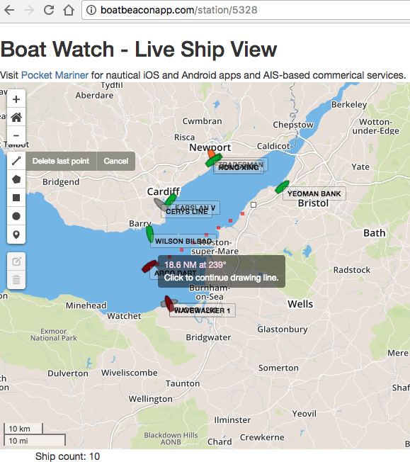
(note all the ships around Hinkley point near Burnham-on-Sea to the south, busy helping with the build of the new Nuclear reactor there).

DYScreen Shot 2017-05-06 at 11.01.47

The Quark picked up ships out to around 20NM from our location. It did not pick up the weaker Class B transmissions  from about 11NM away (purple boat in Cardiff and orange boats in Barry and Hinkley point in the Digital Yacht screenshot). The Digital Yacht maximum range was 39NM just over the expected VHF horizon.

Conclusion

The DY device was far more sensitive than the Quark with nearly double the range for picking up large ships using Class A AIS (12.5W). Class B AIS is much lower power than the class A that ships use and at only 2.5W has a maximum power limited range of around 8-10NM which appeared to be within the Digital Yacht’s capabilities but just beyond the Quark’s.

If you are on a small boat and your AIS aerial is at most 10m above sea level the VHF ship spotting horizon range will be about 12NM (see note at end on calculating VHF horizon range). The Quark easily met that target for spotting ships. With the built in GPS version you can provide GPS to your Wifi only iPAD too. The Quark-Elec A026 would be a great buy on that basis if you want to use it on your boat with SeaNav so you can pick up AIS when out of range of our live internet coverage, for instance when half way across the English channel between Southampton and Cherbourg.

By the way, you don’t have to buy and install an additional aerial to get VHF AIS on your boat, you can share your existing marine band VHF radio aerial via a lossless splitter like this one from Glomex:-https://www.marinesuperstore.com/marine-communication/vhf-antennas/glomex-ais-am-fm-splitter-ra201ais

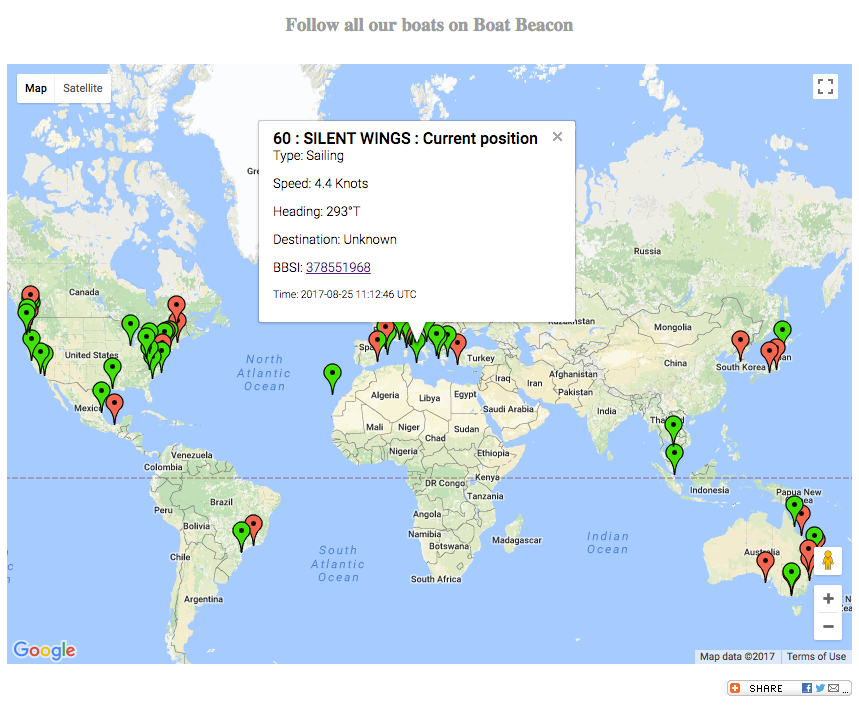
At Pocket Mariner we are also interested in using AIS receivers for our real time global AIS shore based AIS network which we are continually growing, now picking up live positions from over 40,000 ships around the world at any one time with  several hundred AIS receivers and aerials. Although the price point of the Quark is tempting, when you factor in the costs of installing and connecting up an aerial, the 4 fold increase in coverage area the Digital Yacht devices give us wins for shore based AIS stations.

VHF Horizon

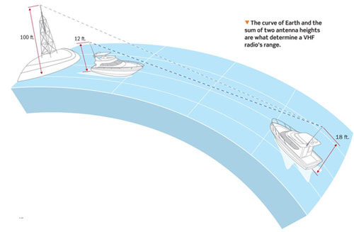
VHF travels in a straight line and its range is limited by the curvature of the earth. The higher the aerial is placed above sea level the further it will see. A simple rule of thumb for calculating the range of an aerial is the square root of its height above sea-level in feet in NMs. So an aerial at 25′ will have a range of 5NM. To get the range that you can pick up targets at you need to combine the range of your aerial and that of the target. So for aerials both at 25′ the range will be just over 10NM. If you prefer metric, take the square root of the height above sea level in meters and then double it to get range in NM. e.g. 9m gives approx 6NM range. An AIS aerial mounted at deck/guard rail  level will only see large ships to about 8NM out!

http://www.literasea.ca/radar-horizon.html

vhfhorizon

Vessel Motion and Position Monitoring in real-time with AISWatch telematics

Pocket Mariner’s AISWatch service now provides Real-time Remote Vessel Motion Monitoring and situation reporting (RTR-VMM). RTR-VMM enables significant improvements to operations efficiency and vessel utilisation with a direct impact on profitability.

Let marine co-ordinators for Wind Farm and Oil rig services optimise operations from base by knowing real time whether the conditions on the support ships are within the safety parameters for personnel and equipment transfer.

Cruise line operators can check the comfort level for their passengers and see if they are having a bad experience with the ship rolling too much or if the ship is running into serious waves and pitching fiercely?

Check the view right now from the Ship’s bridge deck  back at the operations centre. Share the glorious port arrival, sunset and sunrise views from a cruise ship’s bridge deck on the web with current passengers and potential customers.

Instantly know where your ship is and what other vessels are nearby in real-time anywhere in the world.

Remotely monitor equipment, environment and engines on the ship.

Continue reading “Vessel Motion and Position Monitoring in real-time with AISWatch telematics”

AISWatch new features

AISWatch new features

We have added 3 new features to our commercial AISWatch services for 2016. Mobile geofences, history replay extended to up to a week at a time and GIS information overlays. More about these features below. Please contact us if any of these may be of interest to you support@pocketmariner.com or phone +44 1291 689202

Mobile Geofences

Attach geofences to moving ships providing a  closest point of approach (CPA) or Exclusion zone around it. As with the existing geofences these can be quickly added and monitored on the fly via the AISWatch live chart view. Geofences turn red when they have been triggered.Screen Shot 2016-10-04 at 10.21.39

History replay extension

You can now select from 1 hour up to 7 days of AIS history replay and playback at up to 60x real time (1 minute in 1s) in AIS mode.

Graphical information overlays (GIS)

Continue reading “AISWatch new features”

Marine Navigation with FLIRONE Augmented Reality

Augmented Reality with FLIR ONE

MORNING_CALM_BB_AR_FLIR_IOSPocket Mariner collaborated with Practical Boat Owner to successfully complete a demanding night time sea trial of our popular marine navigation apps, SeaNav HD and Boat Beacon with the  FLIR ONE Thermal Imager for iOS; a new, low cost , infra-red thermal imaging camera for the iPhone.  The FLIR ONE makes thermal imaging affordable and accessible to a much wider audience at a fraction of the cost of the higher end marine IR imaging devices. Pocket Mariner have ingeniously integrated the live thermal image with their widely acclaimed iOS Augmented Reality mode providing identification, distance and bearing of the ships and Aids To Navigation in view at night and in fog.  We wanted to see how well and how far off we could spot ships via their infra-red signature and if the FLIR ONE could help with searching for a Man Overboard (MOB).

Practical Boat Owner, the UK’s leading boating magazine, bravely deployed their editors, David Pugh and Ben Meakin, together with Ben’s Impala 28 yacht , “Polly” and intrepid “Woman Overboard” volunteer, Laura, along with Pocket Mariner’s CEO, Steve, on a pitch black night in Southampton water.

Here’s what we saw.

Continue reading “Marine Navigation with FLIRONE Augmented Reality”

SailTimer Wind Instrument, SeaNav and Pebble SmartWatch

Some of SailTimer’s customers asked them if their bluetooth WindInstrument would work with Pocket Mariner’s  SeaNav Marine Navigation app and if the wind information could also be displayed on our free SeaNav Pebble watch companion app. So SailTimer asked us and now it does…
diag copy
windinstruments
The SailTimer WindInstrument is completely wireless, no power of data lines, so the install is far simpler than for other marine wind vanes.  It is the first masthead anemometer  with a digital compass built into the wind direction arrow so you get true wind direction even when docked or at anchor. It sends the wind data via bluetooth and is solar powered with 24 hour running. The WindInstrument if fully weather and waterproof (submersible) and has innovative wind cup blades design to maintain equal accuracy when sailing heeled over.

Continue reading “SailTimer Wind Instrument, SeaNav and Pebble SmartWatch”

Simple 3dB dipole VHF AIS Marine Aerial from co-ax cable

Here’s how we make an AIS tuned 3dB gain VHF aerial using RF-coax cable.
Buy a 5 or 10m length of  50 ohm RF coax cable with bnc connectors already attached – this makes two – http://www.amazon.co.uk/dp/B00JVUP0L4. Cut to required length. Strip back the outer coating at the cut end to a length of 44.4cm + 5cm to make a loop (1/4wave for AIS frequencies). Pull the inner core through the outer sheath and lay the outer sheath back along the length of the coax and trim to 44.4cm. I add a couple of cm to the length so I can bend the tip of the inner core back on itself to hook it over something. Make sure the length of the inner is 44.4cm excluding the looped over end. Cover in heat shrink wrap if you want to make it waterproof and you have a 3dB gain AIS Aerial.
There is a useful video here showing how to do it here :-
and a photo of a 5m long one we made earlier. This one had a range of over 25NM when we put it on the 20th floor of a high rise in Singapore.
Screen Shot 2016-04-08 at 15.07.39

You could also go one step further and make a 6dB  collinear like this from Neil Arundale (I have made and used one of these too and it compared equally with a £120 commercial collinear).

I hope that this inspires someone. If you get connected up please consider sharing your AIS data with us. We can provide a dedicated port and web view for your data.

ShipPlotter AIS sharing to Boat Beacon and Pocket Mariner

Its very easy to set up using the UDP/IP peer to peer sharing feature in ShipPlotter’s I/O settings. See screenshots below. Select enable in the UDP/IP peer-to-peer output, enter the IP address 54.204.25.151 and Remote Port number 5322 (see area circled in red).

ShipPlotterBoatBeacon

Click OK when finished. You will return to the main program window. Click on the “Start” button and you should then see your data on this web page:-

N.B. If you would like your own dedicated UDP port number and web view to share to please email us at support@pocketmariner.com

Dual Channel VHF AIS receiver for under $35 – Boat Beacon, AIS Share and RTL-SDR

Screenshot_2016-03-03-09-53-17 (1)

Got an Android phone? Want Screen Shot 2016-03-04 at 12.32.24a dual channel VHF AIS receiver for under $35? Now there is one thanks to our Boat Beacon app and the Android AIS Share app from ebcTech! All you need is  an RTL-SDR USB dongle,  an android OTG cable , the AIS Share app and our Boat Beacon app and you can see all the ships out to 30NM away (depending on height above sea level). No need for an internet connection, this is a  truly standalone full featured AIS receiver and with Boat Beacon’s new NOAA US Marine charts you have an AIS chart display with Collision detection and alarms too. It takes just a couple of minutes to set it up the first time and then after that it works out of the box. Here is what you need:-

The RTL-SDR USB stick is a software programmable radio receiver and because of its popularity for use in picking up TV and fm radio broadcasts it is incredibly cheap. As low as $10.  It is so powerful it can pick up and demodulate both AIS VHF frequencies at the same time. The one we recommend is the RTL-SDR.COM stick which is around $25  and has several major improvements over generic brands including use of the R820T2 tuner, improved component tolerances, a 1 PPM temperature compensated oscillator (TCXO), SMA F connector, aluminium shielded case with thermal pad for passive cooling and a telescopic aerial that you can extend to the correct length for AIS reception – 44.4 cm.

Next you need an Android OTG cable that lets you attach the RTL-SDR USB dongle to your Android device. They are typically less than $4 and we recommend the Y shapeScreen Shot 2016-03-04 at 12.36.44d ones which allow you to keep your device charging at the same time as using the RTL-SDR dongle. N.B. It is important that you connect the power and the RTL-SDR dongle to the Y cable first before connecting it to your device otherwise it won’t charge the device – there is a video about this here:-  https://m.youtube.com/watch?v=rXiyzfP94AU Make sure you have our Boat Beacon downloaded and installed . Next download and install the AIS Share app from the Play Store. Set up of AIS Share is pretty straight forward .

Installation / First start

Install the driver app from Google PlayTM store. Get it on Google Play https://play.google.com/store/apps/details?id=eu.ebctech.rtl_sdr_ais_driver Start it one time. After that you can close the app ( RTL SDR AIS Driver ) Install AIS Share Get it on Google Play https://play.google.com/store/apps/details?id=eu.ebctech.ais_share Start the AIS Share app go to the setting activity

AisShare Dongle Settings

Set the PPM setting This is really important. For the RTL-SDR.COM USB stick that we recommend this will always be 0 as it comes with a stable pre-tuned oscillator. Google it Set up the UDP Share Start the driver with the pink floating action button.(please do not start / stop too fast , if you have clicked one time .. wait a second ) AisShare start Then check if you are receiving messages. Finally, launch Boat Beacon, go to settings, scroll down to Local AIS, select UDP, then tap on Local AIS Port and enter 10111. AIS Share will continue to run in the background as long as the USB dongle is attached. Watch the ships sail by 🙂 Screenshot_2016-03-04-12-12-06
Screenshot_2016-03-03-09-53-17 (1)

Boat Beacon now has all NOAA US RNC (Raster) Marine Charts available

Pocket Seamless_RNCs_chartMariner were invited to help NOAA with their new raster charts service. We met up with them in the US last year and have been working with them on the trial. NOAA’s Raster Navigational Charts (RNCs) are produced by NOAA’s Office of Coast Survey (OCS) and are designed for marine navigation, but can also be used as a marine base map by GIS users, coastal and ocean planning staff, and the general public. NOAA raster navigational charts (NOAA RNC®) are full-color digital images of NOAA paper charts. They provide a consistent view of the marine environment, but with more than 2,100 individual chart and inset files available, finding the right chart at the right scale can be time consuming.

The trial aimed to create a map service of all 2,100+ raster navigational charts and their insets. The charts display as a seamless mosaic with the map collar or neat line—the information around the chart providing scale and notes—removed. Also, the map service displays only those charts appropriate for the viewing scale and map extent requested (from 1:5 million to 1:1,000 scale!). The seamless NOAA RNCs within the service are updated monthly and represent the most recent version of the RNCs and their respective Notice to Mariners at the time of the update.

The trial has been a great success and we are now busy rolling out the new service to use in our Boat Beacon, SeaNav and Boat Watch apps via a simple In App Purchase. This gives our customers access to all 2,100 charts including all updates. The charts for a region automatically download when you view an area and we cache them locally on your device so that they display instantly the next time you look at the map and will also display when you are not connected to the internet. This also means customers using Boat Beacon as a display for external AIS receivers like Digital Yachts or the new and very competitively priced dAISy one  ($59 – $41) can use Boat Beacon on their boat without needing an internet connection.

Boat Beacon on iOS is first out of the block with support for US NOAA raster charts. You can get it here :-

https://itunes.apple.com/app/boat-beacon-ais-marine-navigation/id494877039

Boat Watch iOS is next and we hope to have Boat Beacon on Android with US raster charts ready shortly following that. We can also add seamless raster chart options for the UK, Ireland, France, Netherlands and Germany – please let us know if you would be interested so we can raise the priority to get the work done – email us at support@pocketmariner.com or answer our quick 3 question survey here 

https://www.surveymonkey.co.uk/r/8CFCWD2

If you want to check out what the charts look like for your area before getting them in our apps you can use the Raster Navigational Charts Google Earth Tool. This is a Google Earth file of all the charts and insets available and is updated monthly along with the map service updates. Clicking on a chart outline gives you information about that chart, such as title, scale, and date updated. Plus, you have the option to overlay in Google Earth a collared or a collarless version of the chart by clicking on the respective preview link.http://nosimagery.noaa.gov/rnc/NOAA_RNCs.kmz

Here are some screen shots from Boat Beacon on an iPad with the US NOAA raster charts around Miami:-

Pleasure Craft Azura selected (note the track in red and our unique trip detail feature which includes departure point as well as the standard destination info – Fort Lauderdale to Key West).

Screen Shot 2016-01-20 at 15.11.31

In this screenshot we have tapped on the mid channel Safe Water mark Aid to Navigation (AIS AtoN) on the approach to Miami (MIAMI LB M). All AtoN’s which have AIS available are selectable on the charts and will show distance and bearing from your location.

Screen Shot 2016-01-20 at 15.12.00

You can instantly toggle the charts on and off:-

Screen Shot 2016-01-20 at 15.24.46